
By Michael Lanza
We’re moments from embarking on one of the hardest, long dayhikes in the White Mountains of New Hampshire when we come to a screeching stop before our first teenager moment. My 16-year-old nephew, Marco, discovers his hydration bladder mouthpiece is cracked and unusable. Then I notice he’s carrying a one-liter bladder from an old, little kid’s daypack he used years ago—hardly enough water capacity for a 20-mile day traversing eight summits. Fortunately, we’re starting today’s hike at the Appalachian Mountain Club visitor center in Pinkham Notch, so we buy him a three-liter bladder. Then I see that his daypack belt has no buckle; he insists it’s fine, but I persuade him that the dollar spent on a new buckle will feel like money well invested by around mile 10.
Minutes later, on the Lost Pond Trail, Marco’s sister, Anna, who’s almost 18, realizes she forgot to fill her water bladder—but doesn’t say anything, worried about holding us up. Luckily, my friend and longtime partner in these ultra-hikes, Mark Fenton—whose 16-year-old daughter, Skye, rounds out our party—notices Anna has no water and urges her to go back and fill it at the visitor center. The delay costs us five minutes, a much smaller price than a severely dehydrated, first-time ultra-hiker.
I’m tempted to make a joke about teenagers, but there are too many friends of mine who could read this and point out the essentials I’ve forgotten on past hikes. That lengthy list that includes the keys to my car awaiting us at the other end of my first attempt at dayhiking the Presidential Range (the weather soured that day, saving me from bearing full responsibility for having to abort our plans), and my boots for a three-day backpacking trip in Maine’s Baxter State Park (I did the hike in old sneakers.)
One of life’s largest gifts is that you can compile enough blunders of your own that you learn to just keep quiet about the smaller mistakes of other people.
Besides, even talking and laughing expends energy, and the five of us will need to use every calorie wisely in order to complete the hike we have planned for today. By nightfall—or hopefully not too long after dark, although we recognize the distinct possibility of this day turning epic—we intend to hike south to north over Wildcat Mountain and the length of the Carter-Moriah Range in the White Mountains.
Anyone who’s hiked in the Whites will appreciate the bald ambition of trying to knock off a 19.9-mile traverse over eight summits more than 4,000 feet high, with 7,200 feet of cumulative elevation gain, in a day.
But even in the notoriously rugged Whites, Wildcat Mountain and the Carter Range harbor some mind-bogglingly steep and rocky trails. The first time I hiked the Carter Range, years ago, I backpacked it in three days—and we didn’t even include Wildcat Mountain. Two summers ago, Mark and I spent a long day on this same traverse, but injuries nagging both of us prevented us from completing what we hope to accomplish today. And this time, we’re attempting it with three teenagers who have little idea of just how deep a hole we’re dragging them into. Only Skye has made just one previous hike of comparable difficulty, the Presidential Range “Death March,” with Mark.
I’m not going into this with any illusions: This could be the hardest 20 miles I’ve ever hiked—and I’ve notched some very long and difficult days over the years. It’s undoubtedly one of the hardest days you could attempt in the Northeast, and arguably harder than the better-known Presidentials Death March, even though the Pressies hike entails a bit more vertical relief.
The question Mark and I grappled with in considering this plan remains open: Can these three young people make it?


Carter Notch
For some years, Mark and I have made an annual big dayhike in the Whites. This year, he wanted to bring Skye, because she actually enjoyed hiking the Pressies Death March with him. That suggestion prompted me to invite my niece, Anna Garofalo, and her brother, Marco, both of them fit, athletic kids who have hiked and backpacked, though never any single day nearly as strenuous as this. (Marco has come close by hiking Mount St. Helens, but even that rugged day doesn’t compare to a 20-mile day in the White Mountains.) Despite my warnings about how hard a day it would be—or perhaps because of my warnings—they leapt at the invitation.
As with the most vertiginous footpaths in the Whites, the Wildcat Ridge Trail can feel like a hybrid of a hard trail and an easy rock climb. From Pinkham Notch, it ascends about 2,000 feet in under two miles. We scramble up gullies of busted rock that make some climber “trails” I’ve hiked look reasonable. Higher up, at open ledges with views across Pinkham Notch to Mount Washington, we lean into the mountain and hope our shoes stick to severely angled, granite slabs.
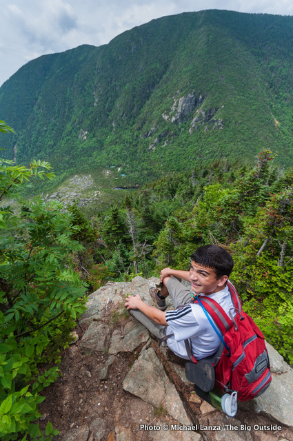
But our three fresh, young horses maintain a strong pace. At an open, rocky ledge at the top of a cliff high above Carter Notch, we stop for photos of smiling adventurers. Everyone’s feeling good. Confidence still rules the day.
From here, we can see a string of peaks stretching ahead of us—our route—and it looks imposing. And we can’t even see the end of our hike from here.
I had hoped we’d reach Carter Notch Hut within three hours; keeping a strong pace and moving efficiently is one of the keys to ticking off a big dayhike. But it takes us four. As we’re eating lunch outside the Carter Notch Hut, Mark and I exchange looks when he says to me and the youths, without making a big deal of it: “We may be on more of a 12-hour pace than a 10-hour pace. It’ll be good just to be aware of that.”
Then, as if to punctuate that point, we embark on the brutal, 1,500-foot climb out of Carter Notch to the highest summit we’ll hit today, 4,832-foot Carter Dome. Just before leaving the hut, I glance at the map, which shows the absurdly steep first half of this uphill stretch as several squiggly contour lines packed together very nearly as tightly as spots on the map indicating cliffs. I’ve labored both up and down this stretch of the Carter-Moriah Trail a few times over the years, and still I look at it and shake my head. You have to marvel at the rare combination of optimism, imagination, and sadism that inspired some trail designers to envision this route.
I’ve hiked rugged trails all over America and the world. I’ve seen very few maintained trails where a person could actually fall to their death without ever leaving the trail.
The Carter-Moriah Trail out of Carter Notch is one of them.


Mount Hight
Not far beyond Carter Dome, the finest summit of our day, 4,675-foot Mount Hight thrusts a bare, rocky crown above treeline, giving us a 360-degree panorama of the Whites. To the immediate west, the Presidential Range looms higher than where we stand, silhouetted through a gauze of humid air. Since shortly after we set out from Pinkham this morning, we’ve been perspiring at brow-mopping, T-shirt-soaking levels, which will continue even into the evening.
If walking the length of the Carter Range feels at times like a cross between hiking and rock climbing, on days like this it also bears a resemblance to swimming. Call it a White Mountains triathlon.
Looking east into Maine, the wooded mountains rise a little lower but no less abruptly in their relief between valleys and summits—the classic Appalachian landscape. Four more thickly forested peaks still lie ahead of us, snaking northward. We can finally almost see the end of our mega-trek, but it still looks insanely far off, and we’ve already put in more than six hard hours of almost constant walking.
As if to remind us that much of our work today is not nearly over, the descent off Mount Hight plunges straight down a rocky stepladder missing every other step.
Ascending Middle Carter, Anna looks unhappy. She and I are trailing minutes behind the others, and she feels she’s holding everyone up. She isn’t sure she can make it. I realize she hasn’t eaten enough and her energy level has crashed, which I know from experience will make your mood crash hard, too. So I insist we stop then and there while she eats something.
The food delivers an immediate improvement in her energy level and mood. Shortly after our break, when we catch up with the others on an open, rocky outcropping, with 360-degree views, she revives and tells me, “I’m going to do this.”


Mount Moriah
On the most popular trails and summits in the Whites—certainly Washington and others in the Presidential Range, as well as Franconia Ridge and smaller peaks like Mount Chocorua that are beloved for their huge views from rocky, open summits—it’s rare to not run into many people. But while we encounter other hikers, for much of today we’re entirely on our own. There are probably a variety of reasons for that. Wildcat Mountain and the Carter Range happen to be parked beside the tallest peak in the Northeast, which pulls hikers in like paper clips to a magnet. And no doubt the difficulty of the hiking here not only dissuades some people, but it slows the pace of most hikers enough that parties are less likely to overtake another.
Whatever the explanation, that degree of solitude amplifies every aspect of the experience—including the sense that you are doing something that’s really, really hard.
The mid-afternoon haze builds up to point where it looks like we could get a thunderstorm, but not a drop falls from the sky. By late afternoon, the sun comes back out, feeling nuclear as we make the tediously long, gradual ascent of Mount Moriah.
We can all feel the miles in the stiffening of leg muscles and the soreness in ankles that get constantly tweaked, twisted, and battered on these trails. All the way up Moriah, like a kid in the back seat, Anna keeps asking me, “Are we almost at the top? Is that the top right there?”
She and I reach the summit of Moriah, a few ticks over 4,000 feet above sea level, as the sun bends close to the horizon, pouring low-angle light across the long arc of mountains we have traversed today. From any perspective, it looks improbable. The other three beat us here and have already started a 4.5-mile descent through woods that will take us well over two hours and seem like a month. We won’t reach the car until 8:45 p.m., in the fading moments of dusk, more than 13 hours after we started our hike.
Anna and I snap photos and linger a few minutes, enjoying the view and the respite from walking. It’s downhill from here; even though it will feel painful and interminable, we know we’ll make it. Anna, Marco, and Skye will remember this hike for a long time, not only for its difficulty, but because one of the greatest experiences in life is to attempt something very challenging, entirely unsure about whether you can do it—even having doubts along the way—and then rise to the challenge and accomplish it. You have slain a dragon.
Mark and I have known that feeling over the years: dayhiking more than 44 miles and 11,000 feet rim to rim to rim across the Grand Canyon and back, thru-hiking the John Muir Trail in a week averaging 31 miles a day, and dayhiking the 32-mile, 10,000-foot Pemi Loop here in the Whites. But he and I find that feeling rarely these days. We know what we can do, so even on a day as hard as today, while we challenge ourselves, we don’t really get that sense of doubt about whether we’ll make it. We’re deprived of that powerful sense of achieving the impossible, of slaying dragons.
So we settle for the next-best pleasure available to us: We live that experience vicariously. Today, without knowing it, Skye, Marco, and Anna have given it to us as a gift by letting us watch them experience it.
Plus, we get to enjoy some teenager moments that are just plain funny.
On the long descent, Anna keeps up a steady volley of questions aimed at me:
“How much farther do you think it is?”
“We must be almost there, right? Are we almost there?”
After several of those inquiries, she delivers my favorite line from her of the day: “I hate to ask this question, but do you know how many more minutes before we get there?”
And between her queries, I can hear her behind me the whole way down, muttering under her breath, “Oh, my feet hurt so much. My legs are killing me. Okay, let’s do this thing.”
See all of my stories about hiking in the White Mountains, including “Still Crazy After All These Years: Hiking in the White Mountains,” “Step Onto Rock. Step Down. Repeat 50,000 Times: A 20-Mile, 9-Peak Presidential Range ‘Death March’,” and “Ask Me: What Are Your Favorite New England Hikes?“
THIS TRIP IS GOOD FOR fit, experienced dayhikers and backpackers, and novice dayhikers and backpackers who are fit, well prepared and, ideally, accompanied by experienced people. Challenges include extremely rocky, steep trails, and weather that can get hot and humid and produce a thunderstorm. The trail is well marked, so route-finding won’t be a problem for anyone with solid map-reading skills. Along the Carter-Moriah Trail between Carter Notch and Mount Moriah, there are four side trails leading to NH 16 that provide opportunities to bail out and shorten the hike.
Make It Happen
Season The prime hiking season in the White Mountains is June through mid-October. Winter hiking skills and gear are usually required from November through mid-spring, and deep snow can make hiking difficult in late April and May.
The Itinerary We traversed Wildcat Mountain and the Carter-Moriah Range south to north, starting at Pinkham Notch and finishing at the northern terminus of the Carter-Moriah Trail, following the Lost Pond Trail for 0.9 mile, the Wildcat Ridge Trail for 4.8 miles, making a 0.4-mile side trip to Carter Notch Hut for a lunch break (we brought all of our own food), and the Carter-Moriah Trail for 13.8 miles. The total distance was 19.9 miles and the cumulative elevation gain was 7,200 feet.
Getting There To leave a vehicle at the hike’s finish, the north end of the Carter-Moriah Trail, from the eastern junction of NH 16 and US 2 in Gorham, N.H., drive east on US 2 for a half-mile. Turn right onto Bangor Street and drive a half-mile to its end, where there’s roadside parking at the trailhead. Start the hike at the Appalachian Mountain Club’s Pinkham Notch Visitor Center on NH 16 in Pinkham Notch, about 20 miles north of Conway, N.H., and 11 miles south of Gorham.
Where to Stay We spent the night before our hike at the AMC’s Joe Dodge Lodge in Pinkham Notch, so we could hit the trail without having to drive in the morning. Joe Dodge Lodge and the AMC’s eight mountain huts are popular; make reservations at least a few months in advance, and further in advance for summer and early-fall weekends, at outdoors.org/lodging/lodges.
Shuttle Service The Appalachian Mountain Club’s hiker shuttle bus operates daily from early June through mid-September, and on weekends and holidays from mid-September through mid-October, stopping at several trailheads throughout the White Mountains. There is a fee. See the schedule at outdoors.org/lodging/lodging-shuttle.cfm.
Permit No permit is required for dayhiking or backpacking in the White Mountains.
Guidebook and Maps White Mountain Guide, from the Appalachian Mountain Club, amcstore.outdoors.org.
Concerns Weather is the biggest hazard, including thunderstorms, strong winds, rain, snow, and whiteout conditions on summits and exposed ridges. Check the forecast for the summits, posted daily at all AMC mountain huts and the Pinkham Notch Visitor Center, and available from the Mt. Washington Weather Observatory, mountwashington.org/weather.
Contact Appalachian Mountain Club, (617) 523-0655, outdoors.org. Pinkham Notch Visitor Center, White Mountains, (603) 466-2721.