By Michael Lanza
The water of Johns Hopkins Inlet lies flat, perfectly reflecting the first patches of blue sky we’ve seen since arriving in Glacier Bay yesterday morning. I rest my paddle across the kayak and listen. A barely audible moan of wind floats down from high in the mountains, then fades away. A bald eagle screeches, briefly piercing the quiet; but as soon as the sound passes, the silence that returns seems as deep as the sea we’re floating on.
On the second afternoon of a five-day sea kayaking trip, 55 miles up this Southeast Alaska fjord where cliffs shoot straight up out of the sea and razor peaks smothered in ice and snow rise thousands of feet overhead, I’m taking a moment to enjoy a rare pleasure: listening to the cacophony of nothing.
My seven-year-old daughter, Alex, who is perfectly content to sit back and let me power our two-person kayak loaded with food and gear, points to the eagle perched in its nest in a snag high up a cliff. “He’s watching the kayakers go by,” she informs me. A harbor seal pops its head above water nearby, inspecting us with dark eyes. Alex faintly catches her breath as she and the seal lock gazes. A moment later, it disappears with a “bloop.”
Then a sharp concussion rips open the quiet.


About six miles away, visible at the other end of the inlet, the mile-wide, 12-mile-long Johns Hopkins Glacier has dropped another immense piece of itself into the sea. The native Tlingits, who have lived on this coast for centuries, call that explosive noise “white thunder,” which strikes me as the best possible descriptor for it.
The Hopkins Glacier is the most active remnant of an unimaginably massive river of ice that filled this realm of liquid water in the geologically very recent past. Tomorrow, we will paddle up this inlet for a close-up view of that dynamic glacier. We’re hoping this improved weather will hold out at least until then.
My family, including my wife, Penny, and our nine-year-old son, Nate, are taking a sea kayaking trip run by Alaska Mountain Guides. With our two guides and six other clients, we’ve come to paddle around Glacier Bay’s upper West Arm, probing deep within a national park the size of Connecticut, at the heart of a contiguous protected wilderness the size of Greece.
By mid-afternoon, we pull up onto a rocky beach at the mouth of the inlet, where we’ll camp for two nights. The sky has mostly cleared and the water’s still dead calm. Icebergs float in the bay. Glaciers pour off of serrated peaks on all sides; tendrils of clouds wrap themselves around the mountaintops.
And throughout the evening, every 15 or 20 minutes, another sharp report booms down the inlet.
 Hi, I’m Michael Lanza, creator of The Big Outside. Click here to sign up for my FREE email newsletter. Join The Big Outside to get full access to all of my blog’s stories. Click here for my e-guides to classic backpacking trips. Click here to learn how I can help you plan your next trip.

Two centuries ago, there was no Glacier Bay. When British Capt. George Vancouver sailed the H.M.S. Discovery through Southeast Alaska’s Icy Strait in 1794, he wrote in his ship’s log about observing a “compact sheet of ice as far as the eye can see.” He was looking at a colossus of ancient, frozen water 4,000 feet thick and up to 20 miles wide that reached more than a hundred miles into the St. Elias Mountains. By the time John Muir visited in 1879, the tongue of ice that had touched the waters of Icy Strait had slid 30 miles backward. He wrote that, at night, “the surge from discharging icebergs churned the water into silver fire.”
Glacier Bay has seen the fastest glacial retreat on the planet. The ice has pulled back 65 miles, unveiling a fjord with numerous inlets and 1,200 miles of coastline. While the national park still has more than 50 glaciers covering 1,375 square miles—more than a quarter of the entire park—most are in declining health, a trend driven largely by one factor: In the past 60 years, the state’s average temperature has increased 3° F., more than twice the average warming worldwide.
A scientist who has studied Alaska’s glaciers for 40 years told me that 99 percent of them are shrinking. Just in the four decades since he first kayaked in Glacier Bay, the number of so-called tidewater glaciers, those that extend from the mountains to the sea in various inlets, has gone from a dozen to five.
Named a national monument in 1925 by President Calvin Coolidge and a national park and preserve in 1980 by President Jimmy Carter, Glacier Bay today attracts more than 250,000 visitors a year. The vast majority of them see the bay from the railing of the park’s tour boat, which is certainly a great experience. But few people go kayaking in the bay—and it is so vast—that kayakers on multi-day trips here enjoy a rare depth of solitude.
Find your next adventure in your Inbox. Sign up now for my FREE email newsletter.
On our first day, we paddled into Reid Inlet and explored the hundred-foot-tall snout of the Reid Glacier, where a river of gray water poured out of a blue-ice cave. After camping at the inlet’s mouth, we started our second morning with a visit to the ruins of a cabin inhabited eight decades ago by Joe and Shirley “Muz” Ibach. The couple staked their claim to mine the land a year before the bay became a national monument, and were permitted to continue living and mining there for another 16 years, making perhaps $13 after expenses in a good year, until their deaths.
Frowning at what’s left of their former one-room wood structure in the middle of the wilderness, Alex asked me, “How did they entertain themselves?” Indeed, it’s hard to imagine such solitude.
Then again, they did have that constant, entertaining soundtrack of white thunder playing in the background.
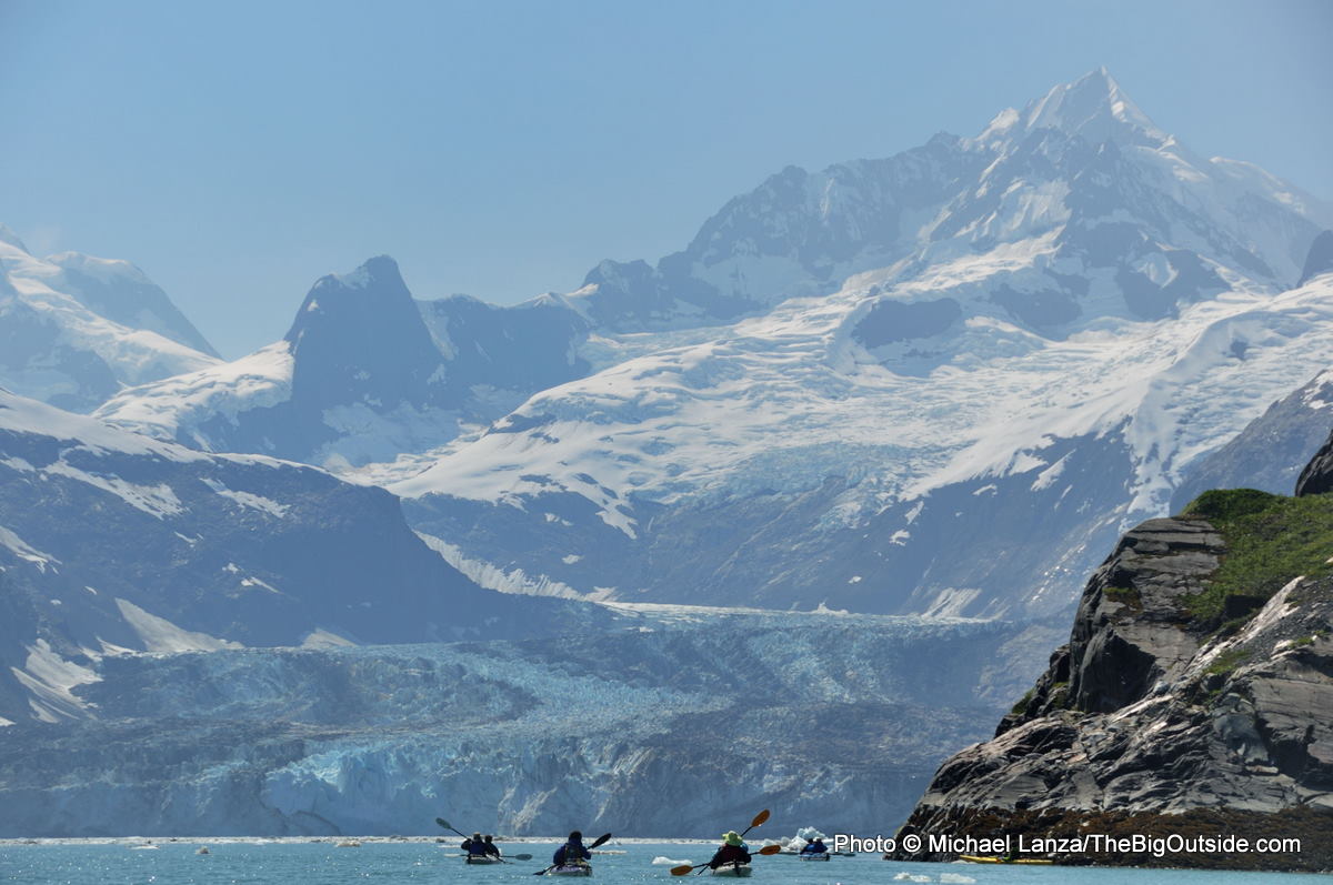
Johns Hopkins Inlet
Another morning of glassy waters greets us as we push the kayaks out into Johns Hopkins Inlet on our third day. Under clear skies and a warm sun that will deliver our trip’s warmest day, pushing 60º F, we cruise slowly up the inlet, passing icebergs ranging from truck-size to chunks of ice that look like abstract mantelpiece sculptures.
Capt. James Cook saw these peaks in 1778, during an identical short reprieve from the typically wet, gray Southeast Alaska weather, and named them the Fairweather Mountains. Given that the region receives six feet of rain a year and is much more frequently enveloped in fog than bathed in sunshine, it may be the most misleading place name on the planet.
We’ve arrived in late July, just a few weeks after Johns Hopkins Inlet was opened to kayaks and boats. The park closes this inlet to human traffic every year during spring and early summer to avoid disturbing the thousands of harbor seals that birth their pups and keep them on floating icebergs to protect them from predators.
I can help you plan the best backpacking, hiking, or family adventure of your life. Click here now to learn more.

Glacier Bay is something of a northern paradise, teeming with life. Humpback whales and orcas ply its waters. On the four-hour park ferry tour up the bay that first morning, en route to our drop-off point, we saw brown bears ambling down rocky beaches and mountain goats scrambling up sea cliffs. Scores of Steller sea lions, the largest males ten feet long and over 2,000 pounds, piled up on the barren rock of South Marble Island, where researchers have counted 1,100 of them.
We spotted black-legged kittiwake nesting in sea cliffs, pigeon guillemot with its red legs and beak, and the more-common tufted puffin as well as the rare horned puffin. Some species threatened or endangered outside Alaska, like the bald eagle and marbled murrelet, abound in Glacier Bay.
The bay also offers a rare natural laboratory displaying a living timeline of plant succession in the wake of deglaciation. In the lower bay, ice-free for 250 years, a mature temperate rainforest of spruce and hemlock grows almost impenetrably thick. As one travels up the bay, the forest gets younger, dominated by deciduous cottonwood, willows, and alder. In the upper bay, there’s little vegetation beyond mosses, lichens, and a few determined wildflowers. Waterfalls plummet hundreds of feet down cliffs scarred by the glacier that scraped past just decades ago. The upper bay opens a window onto what North America looked like when the last Ice Age drew to a close 10,000 years ago.
Read all of this story, including my tips on planning this trip, and ALL stories at The Big Outside, plus get a FREE e-guide. Join now!

As we paddle farther up Johns Hopkins Inlet, the icebergs crowd more densely around us, some as large as tiny islets. We weave more cautiously among them, careful not to get too close—if one abruptly rolls over, it could flip a kayak.
About three hours from our camp, we take out on a beach of sun-warmed, fine black sand a quarter-mile long, littered with blocks of ice gleaming a brilliant white in the sunshine. Gulls squawk. Backing the beach, multi-tiered Chocolate Falls sends a column of brown water crashing over cliffs. A half-mile away, the Johns Hopkins Glacier spans the entire head of the inlet, a sheer wall of ice a mile across and 300 feet tall, roaring at us at irregular intervals.
Thanks so much for writing this out! There are so few trip reports of kayaking trips in Glacier Bay. I’m planning a trip myself and it’s hard to imagine without pictures and trip reports (and youtube videos!) like yours. 🙂
Thanks, Edmund, and best of luck with your trip! It’s an awe-inspiring place.
Anyone out there with personal experience that could answer this comparison question?
Which is a better experience: kayaking in Glacier Bay National Park or kayaking in Kenai Fjords National Park??
I’ve heard that Glacier Bay NP is better for scenery and that Kenai Fjords is better for wildlife.
Hi Beth, thanks for the good question. Kenai Fjords has been on my list but I haven’t been there yet, so I don’t know the answer to your question. Maybe other readers could chime in. Good luck.
Absolutely love this post and the exceptional photography within it. I spent four years in Alaska, though it wasn’t in the SE, I was up in the Interior in Fairbanks. Loved every minute of it and traveled to see other parts of the state every chance I got. Kayaking out by the glaciers was about the only thing I didn’t manage to do – but there’s not question my old home is an incredible place to find all kinds of outdoor adventures. Thanks for sharing and getting the memories going!
Thanks, Shane, I can’t wait to get back to Alaska. Keep in touch.
Your post is really helpful. My family is planning a trip in August with our two kids, ages 12 and 9. Did you bring your own tents, sleeping bags, etc?
Hi Kelly, you’re in for a great adventure, one of my all-time favorites (https://thebigoutside.com/new-year-inspiration-my-top-10-adventure-trips/). You can bring your own camping gear, but it’s also available for rent there. See the links above under Gear Rentals and Outfitters. Have fun.
Thanks for the informative post! The photos are absolutely spectacular. I will have to add this to my life’s to do list.
Hi Jeff, thanks for the compliment, glad you enjoyed this story. I highly recommend this trip.
This looks like a really awesome trip, thanks for sharing! I’m currently planning an unguided trip for next summer, should be a blast!
I’m sure you’ll enjoy it. Glacier Bay is a magnificent place.