
By Michael Lanza
We gaze up at a wall of shattered, crumbling gray and white rock rising several hundred feet above us, a barrier of cliffs separated by severely steep gullies of loose stones. The gullies offer the only remotely feasible routes up or down, but they look about as stable as a mountain of marbles. We’re debating which gully to climb up, and it feels a little like choosing which heavy, hardcover book you want to use to smack yourself in the head.
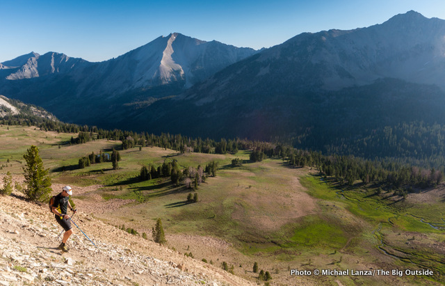
It’s still early on a July morning, and my friends Chip Roser, Scott White, and I are about five miles into a 28-mile, one-day hike through the White Cloud Mountains of central Idaho. On the surface, our goal is simple: a big tour of peaks with national park scenery and remote, national forest obscurity. As it turns out, though, a huge dayhike through one of the largest remaining, unprotected roadless areas in the contiguous United States will also provide fertile mental terrain for contemplating the meaning of wilderness in today’s world.
The White Clouds, as Idahoans know them, may be the most spectacular range that most hikers and backpackers in this country have never heard of. Located across the Sawtooth Valley from the more-famous Sawtooth Mountains, the White Clouds lie far from the highway, behind foothills, largely hidden from view unless you wander into them. So unlike the Sawtooths, which shoot up Teton-like in full view of Highway 75 and the no-traffic-lights town of Stanley, the White Clouds retain a high degree of anonymity in part because you can’t step out of your car and snap a selfie in front of them.
[NOTE: In August 2015, less than a year after this story was first published, President Barack Obama signed a bill designating 275,000 acres of new federal wilderness in Idaho’s Boulder and White Cloud Mountains and Jerry Peak area.]
 Hi, I’m Michael Lanza, creator of The Big Outside, which has made several top outdoors blog lists. Click here to sign up for my FREE email newsletter. Join The Big Outside to get full access to all of my blog’s stories. Click here to learn how I can help you plan your next trip. Please follow my adventures on Facebook, Twitter, Instagram, and Youtube.
Many Idahoans consider that anonymity a good thing—it means plenty of opportunity for solitude in a range that harbors about 150 peaks over 10,000 feet and scores of lakes, many of them above 9,000 feet and a few over 10,000 feet. You can sit by the shore of the highest salmon-spawning waters in North America here, perhaps feeling a little bit envious of the mountain goats, elk, bighorn sheep, black bears, and wolverine who call these mountains home. The highest peak in the White Clouds, 11,815-foot Castle Peak, towers above its surroundings, including the Chamberlain Basin—a beautiful backcountry spot to camp, and a valley we’ll pass through later today.
For decades, advocates have proposed designating the White Clouds as federal wilderness, the highest level of legal protection, ensuring they remain for future generations in the wild condition that we enjoy them today. But the White Clouds, despite being cherished by backpackers, fishermen, and others for their pristine beauty, exist in a sort of political limbo between their current status as part of the Sawtooth National Recreation Area (SNRA)—which includes only part of the range—and either of two higher levels of protection.
So today, one of the largest roadless areas in the Lower 48 still lacks permanent protection.


Boulder Chain Lakes
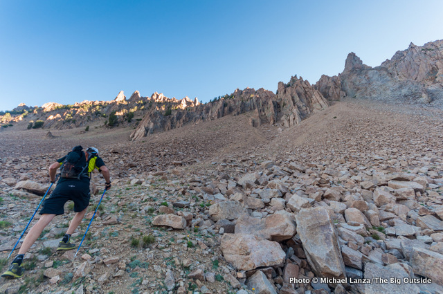
Scott, Chip, and I look up at our dubious choices of routes up between the cliffs above us. Earlier this morning, we hiked over the day’s first pass, between Fourth of July Lake and Ants Basin; two more passes await us later this afternoon, the highest at about 10,000 feet. But the off-trail scramble up and over this wall of cliff bands represents the crux of today’s adventure. Once on the other side, we will walk trails the rest of the way along this 28-mile loop back to our car—and then it’s just a question of whether we have the stamina to make it.
Although at least one guidebook suggests ascending an obvious gully that leads up to a notch in the low point on the ridge above the Born Lakes, we instead decide to scramble up the first gully immediately north (left) of the most prominent pinnacle topping the wall. Scott recommends it to us; he has been through here before, though in the opposite direction (counter-clockwise, while we’re hiking it clockwise). He says we’ll hit an unmaintained user trail as soon as we crest the ridge above the gully he’s suggesting, whereas if we take the gully to the low notch, we would have to pick our way down through cliff bands on the other side to reach that user trail.
No need to make this harder than it has to be.
Find your next adventure in your Inbox. Sign up now for my FREE email newsletter.
We commence an arduous exercise in patience, clawing our way up nature’s version of a gymnasium stair machine. Frequently using our hands, we slide back downhill on every other step uphill. Gullies on steep mountainsides represent the fast lanes on the highway of erosion—every stone and clump of earth seems hell bent on reaching the bottom first. Occasionally, one of us dislodges a bowling ball-size rock, and it tumbles downhill, cracking against other rocks and smashing into a hundred pieces of geologic shrapnel—good incentive to avoid climbing directly above or below one another.
Of course, even on nature’s stair machine, with perseverance, you do eventually reach the top. Cresting the ridge, stepping from the shadow of its west side into the sunlight bathing its east side, we see what Scott promised: a fairly obvious footpath snaking downhill toward the pass called Windy Devil. Beyond that pass, we drop into one of the gems of the White Clouds, the Boulder Chain Lakes valley, speckled with 14 named lakes—the highest, Lonesome Lake, nestled in a bowl of rock at 10,449 feet. The lower lakes sit mostly in green nests of pine forest, some of them partly hemmed in by tall cliffs.
I make a mental note to return here to backpack with my kids and camp at one of these upper Boulder Chain Lakes—although I may take a different route here than the one we’ve taken today.


Castle Peak
The Wilderness Act’s definition of wilderness may be the most-quoted words in the law, calling it “an area where the Earth and its community of life are untrammeled by man, where man himself is a visitor who does not remain.” The “untrammeled” bit engenders lively discussion about whether there’s much of the planet that truly remains largely untouched—especially in the era of rapidly advancing climate change. But the spirit of the law inspires people from all over the world because it sets a high bar for society to maintain these special places just as they are.
The White Clouds are currently the object of two separate conservation efforts: the first a bill in the U.S. House of Representatives, sponsored by Idaho Congressman Mike Simpson, to designate more than 330,000 acres of wilderness in the White Clouds and neighboring Boulder Mountains. That bill has stalled in Congress for more than a decade and appears as likely to become law in the foreseeable future as salmon are likely to rock climb the face of a dam. The second, newer effort is a campaign to persuade President Barack Obama to declare a 571,276-acre Boulder-White Cloud Mountains National Monument, including areas not contained within the SNRA—expanding protection from uses like mining and off-road vehicles.
While there’s no one at the upper Boulder Chain Lakes when we walk by them, the lower lakes are popular—belying the argument that designating lands as wilderness shuts them off from the public. On this particular summer morning, we pass at least a couple dozen men and teenage boys who are camped and fishing at the lower lakes. But increasing distance from roads almost always means fewer people: Later, we will cross paths with just two other hikers as we’re descending into Chamberlain Basin, and then not see anyone until we reach popular Washington Lake and Fourth of July Lake, both within a few miles of the end of our hike.
Want my help planning any trip you read about at my blog? Click here for expert advice you won’t get anywhere else.
At midday, about halfway through our loop, we’re ascending Trail 47 on the east side of Castle Peak toward a 10,000-foot pass known as Castle Divide—one of the high points of our day. And even though we’ve already walked some 14 miles, we’ve hardly broken a sweat all day, thanks to starting in the chilly temps of early morning, cool daytime breezes, the regular shade of pine forest along the way, and trails that never get very steep. In fact, with the exception of the off-trail scramble over the ridge separating the Born Lakes basin from the Boulder Chain Lakes (which can be avoided; see The Itinerary in the Make It Happen section below), much of this hike is only moderately hard—especially if you spread it out over three or four days.
We break out of the forest into alpine meadows carpeted with purple lupine and other wildflowers and march steadily upward through numerous switchbacks. A starkly barren slope of Castle Peak, a massive pile of shattered rock, soars more than two thousand feet overhead, capped by dark, jagged spires.


The Wilderness Act
This year, on the 50th birthday of The Wilderness Act—which established our first 54 wilderness areas and the process by which Congress could create more of them—there are about 30 bills proposing new areas, from Idaho’s Boulder-White Cloud Mountains to the Columbine-Hondo in New Mexico’s Sangre de Cristo Mountains. Unfortunately, those bills sit before a Congress in which too many members cynically perceive collaboration and leadership as failure.
The original nine million acres of wilderness in 54 areas created in 1964 have since grown to almost 110 million acres spread over 758 areas in 44 states, more than half of that acreage in Alaska. California places second on the list, with almost 15 million acres of land protected in pristine condition in perpetuity. The state I live in, Idaho, comes in third with about 4.5 million acres, followed by Arizona, Washington, Colorado, Montana, Nevada, and Wyoming, all with more than three million acres each.
I’ve hiked, backpacked, climbed, paddled, and skied in many of those wild lands, along with innumerable Americans and people from all over the world, all of us drawn to a unique experience that’s available to us because of the foresight of leaders in conservation and politics. An old friend of mine back East is making plans to visit me in Idaho so he can hunt his first elk—something he will have the opportunity to do because we have wilderness where elk thrive.
Read all of this story, including my expert tips on planning this trip, and ALL stories at The Big Outside, plus get a FREE e-guide. Join now!
But if the public demand for wilderness has not diminished, political support for it has gone soft. While nearly 15 million acres of wilderness were designated in the Lower 48 in the 1980s, the number fell to under 10 million in the 1990s, less than five million in the first decade of this century—and only 32,500 acres since 2010, in one place, the Sleeping Bear Dunes Wilderness on Lake Michigan.
Federal politicians have also all but abandoned their obligation to manage existing wilderness: Years of inadequate funding have amassed a $314 million maintenance backlog on the 32,000 miles of trails that crisscross the nation’s 758 wilderness areas. I’ve hiked trails that are maintained on a 10-year cycle. In 10 years, a lot of trees fall down and vegetation overgrows trails.
When three friends and I kayaked the remote canyons of the Upper Owyhee River in southwestern Idaho and southeastern Oregon weeks after much of that area was designated as wilderness and wild and scenic rivers in 2009, the value of that protection seemed no less urgent to us than it must have seemed to the authors of The Wilderness Act a half-century ago.
Plan your next great backpacking trip in Yosemite, Grand Teton, and other parks using my expert e-guides.
Man, what an ambitious venture! Your photos really capture a sense of the steepness…not an easy thing to do.