By Michael Lanza
How was your 2025? I hope you got outdoors as much as possible with the people you care about—and you enjoyed adventures that inspired you. I’m sharing in this story photos from several backpacking and hiking trips I took this year, from the Grand Canyon in March and southern Utah’s Capitol Reef National Park, Buckskin Gulch, and Paria Canyon in April to Idaho’s Sawtooths in August and again in early October and Wyoming’s Wind River Range in September.
That felt like a pretty good year to me (although there’s an argument to be made that my 2024 was better). But I’m very fortunate to be able to get out a lot.
Going through my photos always reminds me not just about the details of these experiences and places—but most of all, what’s most important in my life and why I strive to make getting outdoors a top priority. I know you do, too—that’s why you read my blog.
 Hi, I’m Michael Lanza, creator of The Big Outside. Click here to sign up for my FREE email newsletter. Join The Big Outside to get full access to all of my blog’s stories. Click here for my e-books to classic backpacking trips. Click here to learn how I can help you plan your next trip.

The photos in this story are selected images from my 2025 trips. Whether you want to learn more to take any of them yourself or simply draw some inspiration from them, I think you’ll enjoy this little escape.
Scroll through the photos and short anecdotes from each trip below. Some include links to stories about those places that I’ve already posted—many of which require a paid subscription to The Big Outside to read in full, including my tips and information on how to plan and take those trips. Watch for my upcoming stories about the other places described below. Click any photo to learn more about that trip.
Planning your next big adventure? See “America’s Top 10 Best Backpacking Trips”
and “Tent Flap With a View: 25 Favorite Backcountry Campsites.”

I can help you plan any of these trips or any others you read about at The Big Outside—giving you the benefit of my more than three decades of professional experience identifying, planning, and successfully pulling off great adventures. See my Custom Trip Planning page to learn how I can help you, and my expert e-books to some of America’s best backpacking trips.
I’d love to hear what you think of any of my photos or the places shown in them, or upcoming plans you have. Please share your thoughts in the comments section at the bottom of this story. I try to respond to all comments.
Enjoy my pictures and start now planning your adventures for 2026.
Put more adventure in your life starting today. Sign up now for my FREE email newsletter.

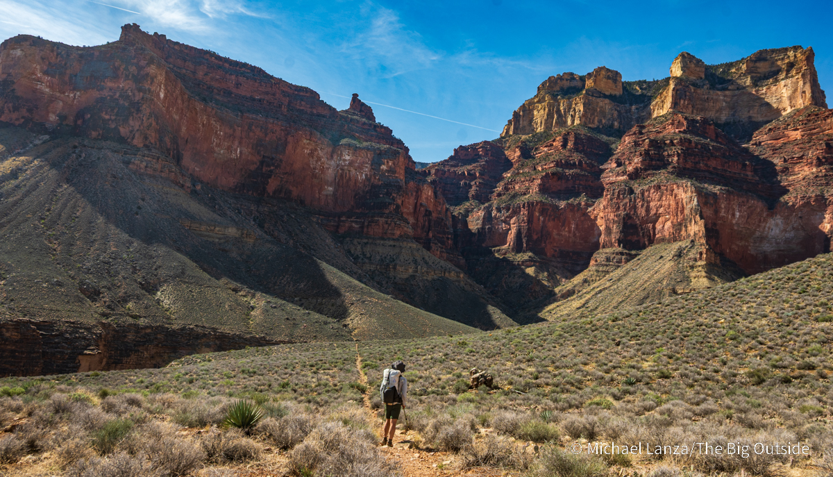
The Grand Canyon Tonto West to the Boucher Trail
In the last days of March, I returned yet again to a park where I have now backpacked and dayhiked in five of the past eight years (and several times further back in my past): the Grand Canyon. (And I just recently reserved a backcountry permit for another trip there in April 2026. I can’t get enough of it.) This time, with my wife, Penny, our 22-year-old daughter, Alex, and three friends—my longtime adventure partner David Ports, Penny’s great friend since college, Annie Black, and Alex’s close friend from college, Harper Meyer—we backpacked four days and roughly 36 miles from the Bright Angel Trailhead to the Hermit Trailhead, finishing via the notoriously steep Boucher Trail. And having now walked all of the major trails off the Grand Canyon’s South Rim, I can testify that the Boucher’s reputation is not exaggerated.
Besides starting on the park’s two most popular trails, the South Kaibab (David and I took this somewhat longer start) and the Bright Angel, our route followed a magnificent stretch of the 95-mile-long Tonto Trail west to Boucher Creek, crossing several tributary creek canyons with soaring cliffs and deep abysses and enjoyed three wonderful campsites, including one beside the Colorado River at Granite Rapids.

We also discovered that the Boucher is as exciting, varied, and breathtaking as it is steep in spots (but not the entire trail). Every time we lifted our eyes from the rocks and dirt at our feet in the steepest sections to look around, the scenery would slam the brakes on whatever focus we had on simply going up and hijack our full attention. The Boucher eventually levels off and makes a long traverse high above the grandest canyon, reminding me yet again that this place looks even better from a remote and lonely trail in the backcountry.
And on that traverse, we passed an established campsite that was an easy pick for my list of the best backcountry camps I’ve hiked past.
See my stories “Backpacking the Grand Canyon: Tonto West to Boucher Trail,” “10 Epic Grand Canyon Backpacking Trips You Must Do,” “How to Get a Permit to Backpack in the Grand Canyon,” all stories about backpacking in the Grand Canyon at The Big Outside, and my expert e-books to backpacking trips in the Grand Canyon and elsewhere.
Plan your next great backpacking trip in Grand Canyon, Yosemite,
and other parks using my expert e-books.

Capitol Reef National Park
An April trip to southern Utah began with my friend Jeff Wilhelm and I dayhiking a roughly 10-mile traverse from the Grand Wash Trailhead on UT 24 to the eastern Cohab Canyon Trailhead on UT 24, including the spur trail to Cassidy Arch. That hike gave us a magnificent window onto Capitol Reef’s varied landscapes, taking us from canyon floors in Grand Wash and Cohab to the high plateau of the Frying Pan Trail and its sweeping views of the towers populating this part of the nearly 100-mile-long Waterpocket Fold.
I have written before that I consider Capitol Reef one of America’s most underappreciated national parks, and this hike demonstrates why.

Capitol Reef has become something of a regular stop for me, even if only for a day or two on a longer trip, because after more than 30 years of steadily exploring more of it, I’m still walking some trails there for the first time (this was my first time across the entire Frying Pan Trail and to Cassidy Arch), and there are others that I’m eager to walk again. The variety and striking natural wonder of this underappreciated gem of Utah’s canyon country keeps me coming back. It’s as nice as southern Utah’s other four parks—but not as crowded, especially once you hike at least a couple miles from a trailhead.
See “The Best Hikes in Capitol Reef National Park” and “The 15 Best Hikes in Utah’s National Parks,” and all stories about hiking and backpacking in southern Utah at The Big Outside.
Get full access to ALL stories at The Big Outside about these and many other trips,
including my expert tips on planning them, plus get a FREE e-book. Join now!


Buckskin Gulch and Paria Canyon

In mid-April, joined by friends David Gordon, Doug Jenkins, and Jeff Wilhelm, I backpacked an overnight hike down southern Utah’s Buckskin Gulch to its confluence with the canyon of the Paria River, which flows south into Arizona and empties into the Colorado River at Lees Ferry, the gateway to the Grand Canyon.
Then, having planned a longer hike but facing a forecast that promised to turn our lovely, sunny, warm weather abruptly into a full-blown snowstorm by afternoon on our second day, we pivoted upstream to finish at the White House Trailhead, the top end of Paria. (We finished as we had confidently planned we would, a couple of hours before the storm commenced—and very happy that we did.)
Unquestionably one of the best backpacking trips in the Southwest, these two canyons combine what’s often described as the country’s or the world’s longest slot canyon, Buckskin, with the much longer and more varied Paria Canyon, which itself has a narrows with high walls that extends for several miles.
I had first backpacked this exact same route more than 30 years ago (and Paria top to bottom, without Buckskin, about 10 years ago), and seeing Buckskin Gulch again after so much time made it feel almost brand new to me. Its walls, often slightly overhanging, rise to perhaps 200 feet high and the canyon widens briefly a few times. But it mostly remains a true, very narrow slot—sometimes barely wider than a person.
Gazing around, I was reminded that the greatest magic of slot canyons is how the diffused light paints the wildly rippled, orange and red walls in too many shades of those colors to quantify, as well as hues of brown and a deep black that looks like an oil spill—creating stark contrasts that delight and mystify the human eye and brain.
See my story about that trip “Not a Dull Moment: Backpacking Buckskin Gulch and Paria Canyon,” my story about a previous, two-family trip backpacking down the length of Paria Canyon, “The Quicksand Chronicles: Backpacking Paria Canyon,” and all stories about hiking and backpacking in southern Utah at The Big Outside.

Are you a fan of the beautiful photos you see at The Big Outside? Click here now
to get professional-quality prints of this blog’s most inspiring images!

The Sawtooth Mountains
In August, two good friends and regular backpacking compadres, Todd Arndt and Mark Fenton, joined my wife, Penny, and me on a four-day, roughly 31-mile, point-to-point backpacking trip through Idaho’s Sawtooth Mountains—a range that’s become my home mountains, having explored it extensively for almost 30 years since I moved to Idaho, from numerous backpacking trips to big dayhikes, bagging a bunch of peaks (adding yet another new one to my list in 2025; see the bottom of this story), backcountry skiing, and rock climbing some classic routes.
And it pleases me to say that, for as much as I’ve already seen of the Sawtooths, on this trip we hiked through areas that were entirely new to me—as well as new to Penny and Todd, who’ve also explored these mountains a fair bit, and entirely new to Mark, on his first trip here. He came away from it loving this wilderness and eager to come back.

While most of our trip was on trails, we did hike over an off-trail pass that was steep at times but straightforward on one side and involved crossing some not-entirely stable talus on the side we descended; all in all, though, not bad. And that pass delivered us into a remote area of the Sawtooths that sees very few backpackers, despite an abundance of beautiful alpine lakes and more high passes with sweeping views of these sharply incised peaks. And Todd and I scrambled up a 10,000-foot summit, a very worthwhile and remote peak to bag (which I’ll describe in more detail in my upcoming story about this trip).
Watch for my upcoming story about this trip. Meanwhile, see “The Best Hikes and Backpacking Trips in Idaho’s Sawtooths” and all stories about backpacking in the Sawtooths at The Big Outside as well as my expert e-book “The Best Backpacking Trip in Idaho’s Sawtooth Mountains.”
I’ve helped many readers plan unforgettable backpacking trips in the Grand Canyon, Sawtooths, Wind River Range, and elsewhere. Want my help with your next trip? Click here.

The Wind River Range Solo
In the first week of September, after a good friend and longtime regular backpacking partner regrettably had to back out of this trip due to a persistent injury, I embarked on my first solo multi-day hike in probably a couple of decades (mostly because I prefer good company and I’m fortunate to have a great bench of partners).
But I wouldn’t have canceled because it was in one of my very favorite mountain ranges in America: Wyoming’s Wind River Range. Excited for it despite not having company, I walked about 64 miles in six glorious days, much of it on trails all new to me, including a big piece of the Continental Divide Trail through the Winds—which, by the way, is widely considered among thru-hikers (at least among the sizable sample I’ve now met) one of the two best sections of the CDT, along with Glacier National Park.
And what an adventure it was.

The Winds are known for its constellation of alpine lakes—estimates include 1,300 name and 1,600 total lakes—and this trip delivered on that reputation even more than I expected: I camped by gorgeous waters every night and walked past an untold number of gorgeous lakes at the foot of big, rocky peaks.
Watch for my upcoming story about that trip. Meanwhile, see “The 10 Best Backpacking Trips in the Wind River Range” and all stories about backpacking in the Winds at The Big Outside.
The right gear makes any trip go better.
See “The 10 Best Backpacking Packs”
and “The 10 Best Backpacking Tents.”

Hiking the Second-Highest Peak in Idaho’s Sawtooths
In the first week of October, with the early-morning temperature bottomed out at a bone-chilling 19° F, my friend Chip Roser and I the hit the trail walking as fast as we could—partly just to warm up, but also because we had a big day ahead of us: hiking the second-highest peak in Idaho’s Sawtooth Mountains, 10,716-foot Mount Cramer.
It was admittedly late in the season for hiking in the Sawtooths, but there wasn’t any snow yet at higher elevations and we had a forecast promising sunshine all day, comfortably cool temps, and little wind; and once the sun finally found us (we started early in the cold shade of the forest), we warmed up quickly and remained so all day. And what a day it was.

From the Upper Hell Roaring Trailhead (requiring a high-clearance vehicle; otherwise, start at the Lower Hell Roaring Trailhead), we hiked Trail 7092 past a glassy-calm Hell Roaring Lake to the northeast corner of Imogene Lake. From there, we found a use trail leading to the start of the long scramble up the rocky east ridge of Cramer.
Cramer’s summit rises to a sharp point on a boulder resembling a very large arrowhead, From there, in the heart of the Sawtooths, you can see the entire range and pick out numerous other peaks and distinctive alpine lakes far below. We even ended that nearly 18-mile October hike, with more than 3,500 vertical feet of uphill and downhill, with a little daylight remaining.
By the way, if you’re interested in a great hike up the highest peak in the Sawtooths (and somewhat shorter than Cramer, but a full day), read about 10,751-foot Thompson Peak and other outstanding hikes in my story “The Best Hikes and Backpacking Trips in Idaho’s Sawtooths” (which I will update in 2026, adding this hike). And see all stories about backpacking in the Sawtooths at The Big Outside.
As you plan your trips for next year, see “America’s Top 10 Best Backpacking Trips,” “The 25 Best National Park Dayhikes,” my 25 all-time favorite backcountry campsites, and my Trips page at The Big Outside.