By Michael Lanza
An unforgettable campsite can define a backcountry trip. Sometimes that perfect spot where you spend a night forges the memory that remains the most vivid long after you’ve gone home. A photo of that camp can send recollections of the entire adventure rushing back to you—it does for me. I’ve been very fortunate to have pitched a tent in many great backcountry campsites over more than three decades of backpacking all over the U.S. I’ve distilled the list of my favorite spots down to these 25.
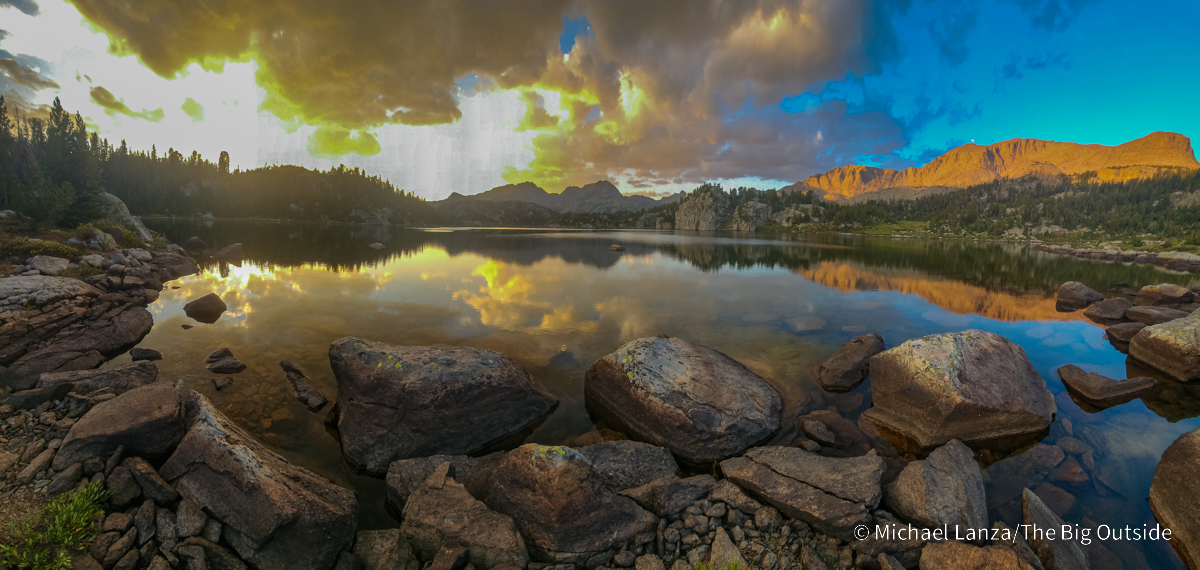
I update this list every year and it becomes a little more difficult almost every time. This year, I’ve added a couple of new campsites in places I visited in 2025: Lower Cook Lake in the Wind River Range (lead photo, above) and Spangle Lake (below) in Idaho’s Sawtooth Mountains. Read what I wrote about both places farther down in this story.
 Hi, I’m Michael Lanza, creator of The Big Outside. Click here to sign up for my FREE email newsletter. Join The Big Outside to get full access to all of my blog’s stories. Click here for my e-books to classic backpacking trips. Click here to learn how I can help you plan your next trip.

Below my top 25 list you’ll find a second list—now just as long—of campsites that were previously in my top 25. Each campsite photo below includes a short description of that trip, and most have a link to an existing story at The Big Outside. In some cases, the photos show the view a few steps from my tent, rather than the camp itself.
I share a brief anecdote with each photo because, for me, each campsite isn’t merely a beautiful scene: it is a story and a memory. Because that’s what camping in the wilderness is all about.
I’d love to read your thoughts about any of these places or your suggestions for campsites that belong on my list; I’m always looking for trip ideas. Share them in the comments section at the bottom of this story. I try to respond to all comments.
Sweet dreams.

Sahale Glacier Camp, North Cascades National Park

We slogged up Sahale Arm into a cold, wind-driven rain, unable to see more than a hundred feet in any direction. But as my friend David Ports and I reached Sahale Glacier Camp (lead photo at top of story), the rain and wind abated and the clouds dropped below us, giving us a view of the earth falling away into a bottomless abyss a few steps from our tent door. A mountain goat strolled past our camp.
Perched at the top of Sahale Arm and the toe of the Sahale Glacier, at 7,686 feet, the highest designated campsite in Washington’s North Cascades National Park overlooks what appears to be a boundless, wind-whipped sea of sharpened peaks smothered in snow and ice, among them Johannesburg, Baker, Shuksan, Glacier Peak, and in the far distance, Mount Rainier.
See my story “Exploring the ‘American Alps:’ The North Cascades” and all stories about backpacking in North Cascades National Park at The Big Outside.
Find your next adventure in your Inbox. Sign up now for my FREE email newsletter.

Beside Royal Arch, Grand Canyon National Park

Backpacking the 34.5-mile Royal Arch Loop, the most remote and arguably the most rugged and lonely established South Rim hike in the Big Ditch, three friends and I put in a monster first day to reach the campsite beside Royal Arch—and was it ever worth the effort. We descended Royal Arch Canyon, which involves slow, strenuous, and exposed scrambling in spots—but is also lush with hanging gardens growing along its vibrant creek, which plunges through several crystal-clear pools—until we came into view of the arch, the Grand Canyon’s largest natural bridge (it’s water carved, so technically a bridge, not an arch).
We passed beneath the tall, thick arch (which provided ample shelter during dinnertime rain showers) and walked just beyond it to a flat ledge more than large enough for our two tents, directly beneath a towering sandstone pinnacle. Just steps beyond our ledge loomed a vertical, 200-foot pour-off dropping into the lower section of Royal Arch Canyon—a reminder not to wander far from the tents after dark. Come morning, dawn light would set the red walls of that lower canyon ablaze. For the four of us, all longtime backcountry explorers, this was an all-time best campsite.
See my story “Not Quite Impassable: Backpacking the Grand Canyon’s Royal Arch Loop” with lots of photos, a video, and information on how to pull off this trip, and all stories about Grand Canyon backpacking trips at The Big Outside.
Planning a backpacking trip? See “How to Plan a Backpacking Trip—12 Expert Tips”
and “How to Know How Hard a Hike Will Be.”

Helen Lake, John Muir Trail, Kings Canyon National Park

Wind-driven rain and hail pounded us as we backpacked the John Muir Trail through the Evolution Basin on the eighth day of a nine-day, 130-mile hike through the Ansel Adams and John Muir Wildernesses and Kings Canyon National Park in California’s High Sierra, mostly on the JMT. The rain tapered before we crossed 11,955-foot Muir Pass in early evening, but gray-black storm clouds still threatened. A little while later, we pitched our tents on the only tiny patches of rock-free, flat ground we found above Helen Lake, at around 11,600 feet, drawing the curtain on an 18-mile day with over 5,000 feet of uphill and downhill. There have been few days when I’ve walked that far through grander wilderness.
The storm passed, granting us a dry, calm evening. The setting sun cast soft alpenglow upon a peak behind us and burnished the clouds hovering over the western horizon a dark burgundy. But the real payoff came the next morning, when the rising sun ignited the rocky faces of peaks across Helen Lake. The lake and a tiny tarn—more like a big puddle—near our camp offered razor-sharp reflections of our surroundings. Despite the weather that chased us there and our rocky tent sites, Helen Lake burned itself into memory for all three of us as an inspirational spot.
In fact, as always happens when I backpack through the High Sierra, we had a few truly glorious campsites on that August 2022 hike, including at Thousand Island Lake and Minaret Lake. See my story about that trip, “High Sierra Ramble: 130 Miles On—and Off—the John Muir Trail,” and “10 Great John Muir Trail Section Hikes.”
Want to read any story linked here?
Join now to read ALL stories and get a free e-book!


No Name Lake, Glacier National Park
With two of the six camps on my reserved permit closed due to bear activity when two friends and I arrived at Glacier National Park in the second week of September, we had to scramble to create a new permit based on backcountry campground availability—and ended up with an itinerary very similar to a hike I’d done in Glacier five years before (see this story). But in Glacier, there are no consolation prizes, only trails that awe every time you walk them.
We backpacked a seven-day, north-south traverse of the park, mostly combining the primary and alternate routes of the Continental Divide Trail from the Belly River Valley to Two Medicine, hiking through the Ptarmigan Tunnel and finishing with the Dawson Pass Trail’s alpine traverse overlooking the peaks in the park’s remote heart. But unlike last time, we spent our final night at No Name Lake, where a calm morning brought the kind of lake reflection you want to frame for a wall at home (as I did). Another surprise treat on that trip was beautiful evening and morning light at Morning Star Lake.
See my story “Déjà Vu All Over Again: Backpacking in Glacier National Park” and all stories about backpacking in Glacier at The Big Outside.
Get my expert e-books to the best backpacking trip in Glacier
and backpacking the Continental Divide Trail through Glacier.
The Narrows, Zion National Park
It was one of the most glaring omissions in my resume as a backpacker: I had never hiked The Narrows of the Virgin River in southern Utah’s Zion National Park. (I actually had a permit to do it in October 2013, when Congress shut down the federal government, closing all the national parks and temporarily crushing my hopes of finally ticking off that classic hike.)

Then an unexpected opportunity arose: I had a window for a four-day trip in early November and saw an unusually good forecast for southern Utah. I broached the idea of backpacking The Narrows to my friend, David Gordon, he leapt at the chance, and we got a last-minute permit for a very popular trip at a time of year when there are far fewer people either competing for a permit or dayhiking from the bottom.
I shot this photo and video of David at our campsite, Narrows no. 1, in early evening; the slot on the left side of the photo is The Narrows—we had emerged from that slot, hiking downstream, just an hour or so earlier.
See my story “Luck of the Draw, Part 2: Backpacking Zion’s Narrows” and all stories about Zion National Park at The Big Outside.
Click here now to get my expert e-book to backpacking Zion’s Narrows.

Death Canyon Shelf, Grand Teton National Park

I could rattle off a list of gorgeous campsites in Wyoming’s Tetons, a park I’ve visited well over 20 times and never get tired of. But I decided to include just the two camping zones I consider the best places to bed down in the Tetons backcountry and can be reached by trail: Death Canyon Shelf (above and at right) and the North Fork of Cascade Canyon (below).
I’ve camped a few times in different spots on Death Canyon Shelf, a broad, three-mile-long bench at about 9,500 feet. With the earth dropping away abruptly into Death Canyon on one side, cliffs rising some 500 feet on the other side, and views across the jagged peaks and canyons of the Tetons—reaching all the way to the Grand Teton—there are few spots with such sweeping and dramatic panoramas.
I’ve watched moose in Death Canyon through binoculars from the cliff tops and deer grazing around our campsite, was awakened one night by a bull elk outside our tent—and have usually caught a spectacular sunset followed by an equally glorious sunrise.
After the Teton Crest Trail, hike the other nine of
“America’s Top 10 Best Backpacking Trips.”

North Fork of Cascade Canyon, Grand Teton National Park

On my most-recent backpacking trip on the Teton Crest Trail, in August 2019, three friends and I started up the North Fork of Cascade Canyon on our second afternoon—having already enjoyed two days of a constant stream of breathtaking scenery. Where the trail emerges from forest into boulder-strewn meadows with a first, sweeping view of the canyon, my friend David looked over his shoulder and exclaimed, “Wow!” He was gazing down the canyon at the sheer north face of the Grand Teton rising several thousand feet above us (photo above).
We found a campsite in a copse of pine trees with a ledge that afforded an unimpeded view down the canyon as the setting down turned the Grand golden and then ruby red (photo at left). Getting an early start the next morning, we passed a massive bull moose strolling across a meadow on our way to Lake Solitude—which we had to ourselves at a time of day when its still waters offered a perfect mirror image of the surrounding cliffs and peaks. And the eye candy just kept getting better as we hiked the TCT high up a canyon wall to Paintbrush Divide at 10,700 feet.
See my stories “A Wonderful Obsession: Backpacking the Teton Crest Trail” and “American Classic: Backpacking the Teton Crest Trail,” and my e-book “The Complete Guide to Backpacking the Teton Crest Trail in Grand Teton National Park.”
I’ve helped many readers plan an unforgettable backpacking trip on the Teton Crest Trail. Visit my Custom Trip Planning page to learn how I can help you plan yours.
Dying to backpack in the Tetons? See my e-books to the Teton Crest Trail and
the best short backpacking trip there.

Precipice Lake, Sequoia National Park
It almost seems unfair to compare other places to the High Sierra, Wyoming’s Teton Range and Wind River Range, Glacier National Park, or the Grand Canyon; those destinations dominate this list in part because I keep returning to them, but I think the photos speak for themselves. On a six-day, family backpacking trip in Sequoia National Park, we camped at two alpine lakes that deserved placement on this list: Precipice Lake and Columbine Lake (see Past Favorite Backcountry Campsites below these 25 favorites).
Precipice wasn’t even part of the planned itinerary; we intended to go beyond it, over Kaweah Gap, to camp in the Nine Lakes Basin. But when we reached Precipice in late afternoon on our third day, we decided within minutes to stop for the night. Cliffs of clean, white granite with black streaks ring much of the compact lake’s shoreline. The mouth of the outlet creek provides an excellent pool for a chilling dip. Granite ledges above the lake have flat areas for tents or to just lay out bags and sleep under the stars (as my 12-year-old son and I did). The evening alpenglow on the cliffs reflected in the lake and on 12,040-foot Eagle Scout Peak towering above Precipice, put the icing on the cake.
See my story “Heavy Lifting: Backpacking Sequoia National Park” and all stories about backpacking in the High Sierra at The Big Outside.
Want to hike the Teton Crest Trail, John Muir Trail, or another trip?
Click here for expert advice you won’t get elsewhere.

Titcomb Basin, Wind River Range
The views kept getting better with every mile on the first day of a three-day, 41-mile loop that two friends and I backpacked from the Elkhart Park Trailhead in Wyoming’s Wind River Range in mid-September. But as we entered the long, alpine valley called Titcomb Basin to find a campsite for the night, craning our necks at the cliffs and peaks towering overhead, we immediately realized it was one of the prettiest backcountry spots any of us had ever seen.

An alpine valley at over 10,500 feet, Titcomb Basin sits below mountains on the Continental Divide that soar more than 3,000 feet above the Titcomb Lakes in the valley, the highest of which is 13,745-foot Fremont Peak. In fact, high peaks flank the valley on three sides like a long, narrow horseshoe. The only easy way in and out is via the trail entering the mouth of the basin. The next day, we hiked an off-trail route over Knapsack Col at about 12,200 feet, at the upper end of Titcomb, descending another trailless alpine valley speckled with wildflowers.
Every time I return to the Winds, it feels like a reminder that I need to get there more often. In fact, I don’t think I’ve ever had a mediocre campsite in the Winds, including the six nights I spent in August 2020 on the 96-mile Wind River High Route.
Read my feature story about that 41-mile hike, “Best of the Wind River Range: Backpacking to Titcomb Basin” and all stories about backpacking in the Wind River Range at The Big Outside.
Which puffy should you buy? See my picks for “The 12 Best Down Jackets”
and
“How You Can Tell How Warm a Down Jacket Is.”

Alice Lake, Sawtooth Wilderness
In the last week of June—not yet summer in the mountains—my son, Nate, and I backpacked with two friends to one of the gems of Idaho’s Sawtooth Wilderness: Alice Lake. While the ground was mostly dry and snow-free in the valleys, we had a frigid ford of a creek running knee-deep and fast with snowmelt, and then encountered up to three feet of snow still on the ground for the last hour or so to Alice Lake, which sits at 8,598 feet below an eye-catching row of granite pinnacles. We found Alice still partly frozen over. But the calm of late afternoon and then the next morning served up a glassy reflection of the snowy peaks beyond that illustrates why this area is a favorite among Sawtooths aficionados.
I’d been to Alice Lake a few times before, as had Nate, on his first wilderness backpacking trip—and one of the first of our annual “Boy Trips”—when he was six years old. In fact, on this recent visit, I recognized and pointed out to Nate the campsite where, seven years earlier, I hurriedly threw up our tent just before a violent thunderstorm rolled in. This time, we just spent one night out there, early enough in the season that we had a chilly night and no mosquitoes. Alice Lake has become popular and is usually overcrowded on summer weekends; plan to be there on a weeknight or pick another spot.
See my stories “The Best of Idaho’s Sawtooths: Backpacking Redfish to Pettit,” “The Best Hikes and Backpacking Trips in Idaho’s Sawtooths,” and all stories about backpacking in the Sawtooths at this blog, plus my e-book “The Best Backpacking Trip in Idaho’s Sawtooth Mountains.”
Click here now for my expert e-book to the best backpacking trip in Idaho’s Sawtooths!

Below the Chocolate Drops, Maze District, Canyonlands National Park
After an arduous descent with some exposed scrambling off Maze Overlook, on a five-day, roughly 46-mile, early March backpacking trip in the Maze District of southern Utah’s Canyonlands, three friends and I followed occasional cairns down the South Fork of Horse Canyon. After some searching, we located our quarry—a small but clear pool perhaps four inches deep, one of the few springs we would find flowing in The Maze.
Our packs newly laden with many pounds of water, we hiked about a half-mile beyond the spring into the mouth of a canyon traversed by the Maze’s Chimney Route. Turning onto a sandy footpath, we walked up a short, dead-end side canyon and found soft, flat ground for our tents, surrounded on three sides by tall cliffs of desert varnish. Rising above the canyon rim behind our camp, one of the Chocolate Drops—distinctive stone towers, visible for miles in every direction, colored a darker shade of brown than most of the surrounding landscape—seemed to peer down at us curiously.
We spent two nights in that wonderful, secluded campsite, dayhiking a nearly nine-mile loop from it that linked up two thrilling and improbably circuitous routes through the Maze, and marveling at how the simultaneously warm and cool light of March days constantly transformed our campsite’s canyon walls.
See my story about that trip, “Farther Than It Looks—Backpacking the Canyonlands Maze” and all stories about Canyonlands National Park at this blog.
Hike all of the “12 Best Backpacking Trips in the Southwest.”

Evolution Lake, John Muir Trail, Kings Canyon National Park
The first time I walked up to the shore of Evolution Lake, on my thru-hike of the John Muir Trail, I couldn’t see the lake. Arriving there after dark, we laid out our sleeping pads and bags on granite slabs under the stars and quickly nodded off. Catching our first glimpse of our environs at first light the next morning actually made it more magical, because we got to watch daylight slowly reveal this magnificent alpine valley to us.

The second time I walked up to Evolution Lake, on a nine-day, 130-mile hike through the High Sierra in August 2022, my two companions and I arrived on a beautiful morning—and that’s a place that will make you turn in a circle and gape. At 10,852 feet, surrounded by soaring cliffs that rise to tall peaks on all sides, including the 13,000-footers Mounts Mendel and Darwin and the 12,329-foot Hermit, it’s the lowest lake in the Evolution Basin and has the most protected camping. While we were moving on—commencing one of the JMT’s sections that earn it the nickname “America’s most beautiful trail” (a day that concluded at Helen Lake, described in the writeup above)—part of me wished we were spending the night there. I’ve also felt that way both times I’ve backpacked past Wanda Lake in the upper end of Evolution Basin.
See my stories “Thru-Hiking the John Muir Trail in 7 Days: Amazing Experience, or Certifiably Insane?” “High Sierra Ramble: 130 Miles On—and Off—the John Muir Trail,” and “10 Great John Muir Trail Section Hikes,” and all stories about backpacking the JMT at The Big Outside.
The Big Outside helps you find the best adventures.
Join now for full access to ALL stories and get a free e-book!

Elizabeth Lake, Glacier National Park
The chilly September air pinched our faces as we took the first steps from our campsite on Elizabeth Lake, on our second morning backpacking the Continental Divide Trail through Glacier. The still, glassy water captured a razor-sharp, upside-down reflection of the jagged mountains flanking it. Then we heard the sound: a high-pitched, nasal whine that built into something like a shriek, the note suspended for several seconds before it was abruptly cut off. It was an elk somewhere in the forest nearby, bugling an invitation to prospective mates.
The campsite at the head of Elizabeth Lake, tucked into the forest just a minute’s walk from the lakeshore beach, not only graced us with that elk bugle, but we also saw our first two bears of the trip while hiking along the lake that morning. While we would hear elk bugling almost every morning and evening on that trip, and more bears as well as mountain goats, bighorn sheep, and moose, Elizabeth Lake awed us with its morning reflection of mountains and set the tone for a consummate Glacier experience that turned into one of my all-time best backpacking trips.
See my story “Wildness All Around You: Backpacking the CDT Through Glacier” about that 94-mile backpacking trip. Click here to get my downloadable e-guide that will tell you everything you need to know to plan and take that trip (including some shorter variations of it), and click here for my e-guide to the best backpacking trip in Glacier.
Get my expert e-books to the best backpacking trip in Glacier
and backpacking the Continental Divide Trail through Glacier.

Along the Highline Trail, Wind River Range
Backpacking one of the premier long footpaths in the Winds, the Highline Trail, on a five-day, roughly 43-mile loop from the New Fork/Doubletop Mountain Trailhead at New Fork Lakes, my wife, Penny, our friend, Chip, and I reached an unnamed, small tarn beside the trail late one afternoon and the view stopped us in our tracks. We walked around the tarn and a few hundred feet beyond it to a flat area on a low rise.
We pitched our tents overlooking grassy meadows littered with glacial-erratic boulders that sloped languidly down to the lower of the Twin Lakes. Beyond that lake, the far side of the valley shot upward to a pair of behemoths reaching for the clouds: 12,119-foot Sky Pilot Peak and 12,224-foot Mount Oeneis. Culminating a day when the miles we hiked—10—again exceeded the number of other people we saw, it felt like we’d found an appropriate home for the night.
See “Backpacking Through a Lonely Corner of the Wind River Range” and all stories about backpacking in the Wind River Range at The Big Outside.
Get the right pack for you. See “The 10 Best Backpacking Packs”
and the best ultralight backpacks.

Overland Lake, Ruby Crest Trail
My family reached Overland Lake in late afternoon on day two of a four-day, approximately 36-mile traverse of the Ruby Crest Trail in Nevada’s Ruby Mountains. Immediately—and literally—the three teenagers (including a friend of our daughter’s) staked out their tents turf on the flat top of rocky ledges just a few steps (but several feet) above the wind-whipped waters of the lake.

Although the wind blew all that night—and my wife and I pitched our tent in a more protected spot amid trees about 25 feet behind their tents—we all enjoyed eating and hanging out on that ledge while the evening sun poured alpenglow onto the west-facing peaks and cliffs above Overland Lake.
For several years, I’d been hankering to hike the Ruby Crest and explore a wilderness area that sees relatively few backpackers and dayhikers compared to marquis parks and mountain ranges around the West. We saw wildflowers blooming and incredible terrain, as well as relatively few mosquitoes… or other backpackers. Overland is a logical stop for Ruby Crest Trail backpackers, sitting at the southern end of a 12-mile day that stays high above treeline, with sweeping views.
See my story “Backpacking the Ruby Crest Trail—A Diamond in the Rough.”
I can help you plan any trip you read about at my blog. Find out more here.

Painter Basin, High Uintas Wilderness
On the third afternoon of a six-day, roughly 58-mile loop hike in northeastern Utah’s High Uintas Wilderness, we reached our second 11,000-foot pass of the day—Trail Rider Pass at 11,700 feet—and paused to catch the breath stolen away by both the climb and the view of an imposing row of 13,000-foot peaks, including 13,528-foot summit of Kings Peak, Utah’s highest.

Then we descended through switchbacks into an alpine garden of rocks and creeks called Painter Basin, where we pitched our tents at around 11,000 feet in the long shadow of Kings Peak. The sun dipped behind Kings, igniting the tall, billowing clouds that filled the sky in a wide arc overhead—a beautiful evening that foreshadowed a night sky riddled with stars. The next day, we dayhiked some 10 miles and 2,500 vertical feet to the crown of Utah, a fun and scenic day.
I returned to Painter Basin in early October 2024 (going on short notice with an unusually good weather window) with my son on the first night of a four-day, roughly 60-mile traverse mostly on the Uinta Highline Trail—and Painter graced us with lovely dawn light on those big peaks. Much of both trips occurred between 10,000 and 12,000 feet and delivered a considerable degree of solitude and beauty.
See my stories “Backpacking—and Sandbagging—Utah’s Uinta Highline Trail” and “Tall and Lonely: Backpacking Utah’s High Uintas Wilderness” and all stories that feature the High Uintas Wilderness at The Big Outside.
Get a full wilderness experience.
See “12 Expert Tips For Finding Solitude When Backpacking.”

Spangle Lake, Sawtooth Wilderness
The first time I hiked to Spangle Lake, deep in the Sawtooths, on this trip some years ago, I thought, “I have to get back here again and spend the night next time.” In August 2025, with my wife and two good friends (one of whom was seeing the Sawtooths for the first time and fell deeply in love), I did just that—and we discovered a spacious campsite hidden in forest, but just above the lakeshore with a broad view of the entire basin.
Besides delighting in that camp at Spangle on our four-day trip, we hiked up a lake-filled valley with no official trail but a good user path; swam in rarely visited lakes; walked trails that I’d not yet left footprints on even after numerous trips here; crossed five high passes; and bagged two summits with amazing 360s. Since my first trip into the Sawtooths a few decades ago (in a previous century), I’ve repeatedly found myself exploring new corners of these mountains and being continually enchanted. On that recent trip, it happened again.
See my story about that trip, “Splendor and Solitude Deep in Idaho’s Sawtooth Mountains,” “The Best Hikes and Backpacking Trips in Idaho’s Sawtooths,” all stories about backpacking in the Sawtooths at this blog, and my e-book “The Best Backpacking Trip in Idaho’s Sawtooth Mountains.”
Lastly, don’t miss two more photos from Sawtooths campsites in my list of Past Favorite Backcountry Campsites (see below)—which speak volumes about the alpine lakes of the Sawtooth Mountains.
Do you love backcountry lakes?
Check out these photos of the most gorgeous wilderness lakes I’ve ever seen.

Johns Hopkins Inlet, Glacier Bay National Park
For one of the trips for my book about taking our kids on wilderness adventures in national parks facing threats from climate change, we took a five-day sea kayaking trip in southeast Alaska’s Glacier Bay, where cliffs shoot straight up out of the sea and razor peaks smothered in ice and snow rise thousands of feet overhead. We watched bald eagles and other birds flying overhead, harbor seals popping up out of the water near our boats, Stellar sea lions honking and carrying on while sprawled on the rocks of South Marble Island, and brown bears roaming rocky beaches looking for food.
We spent two nights at this campsite near the mouth of Johns Hopkins Inlet. From there, we kayaked up the inlet to within about a quarter-mile of the mile-wide snout of the Johns Hopkins Glacier; a thousand or more seals occupied floating icebergs or swam around the inlet. Throughout the evenings and mornings in camp, we listened to that massive glacier calve another bus-size chunk of itself into the sea every 20 or 30 minutes, with an explosive sound the native Tlingits called “white thunder.”
See my story “Back to the Ice Age: Sea Kayaking Glacier Bay.”

Are you a fan of the beautiful photos you see at The Big Outside? Click here now
to get professional-quality prints of this blog’s most inspiring images!

Beside Hance Rapids, Colorado River, Grand Canyon National Park
The first day of a three-day backpacking trip in the Grand Canyon with my 10-year-old daughter, Alex, and two other families was a tough one: descending nearly 5,000 vertical feet in 6.5 miles on the rugged New Hance Trail. By the time we reached our campsites beside the Colorado River, everyone was whipped. But sometimes it takes a hard day of hiking to reach a magical spot, and this lonely corner on the floor of the Big Ditch is a pretty good place to rest tired legs.

Our front porch offered a view of redrock cliffs just across the river. The gravelly drone of Hance Rapids drowned out all other noise. Night fell like a black curtain to reveal a sky riddled with far more bullet holes than all the road signs in Arizona combined (and these holes glowed). Morning brought a sharp chill to the air—it was November—and the slow, patient unfolding of dawn light descending (kind of like very tired backpackers) from the South Rim a vertical mile above us to the mid-canyon geologic layers and, finally, bathing our campsite in warmth. We left there completely rejuvenated.
See my story “A Matter of Perspective: A Father-Daughter Hike in the Grand Canyon” for more images, a video, and tips on planning this trip, and all stories about Grand Canyon backpacking trips at The Big Outside . See also my story “The Best Backpacking Trip in the Grand Canyon,” about a trip where the beach at Hance Rapids is a potential campsite, and get my expert e-book also titled “The Best Backpacking Trip in the Grand Canyon” to find out all you need to know to plan and pull off that amazing multi-day hike.
So many spots where I’ve camped in the Grand Canyon would make most people’s list of best camps ever. But I’d be remiss to not mention that every one of our camps for five nights on the GC’s Gems Route—the most remote section of the Tonto Trail and one of the canyon’s most remote trips—featured breathtaking views and a shocking amount of solitude. See my story “Let’s Talk Water: Backpacking the Grand Canyon’s Gems.”
Get my expert e-books to “The Best First Backpacking Trip in the Grand Canyon”
and “The Best Backpacking Trip in the Grand Canyon.”

Lower Cook Lake, Wind River Range
On the first day of a solo backpacking trip of more than 60 miles in September 2025, I walked up to Lower Cook Lake (also the lead photo at the top of this story), not far off the Continental Divide Trail, and found a camp overlooking the entire lake, mountains in almost every direction—and not another person in sight (which became a common experience on much of that trip). Then, not long after I’d finished my dinner, the sunset kept me busy with my camera and my sense of peace nearly until darkness fell.

In fact, I enjoyed wonderful campsites on lakes large and small every night on that trip—and hiked past many more that seemed to call out to me to stop and pitch my tent there, including Mae’s Lake (which I’ve now hiked past a few times, a regrettable truth that I remain determined to rectify). The Winds are that kind of place.
See my story “Backpacking Six Days Solo Through the Wind River Range” and all stories about backpacking in the Wind River Range at The Big Outside.

Thousand Island Lake, John Muir Trail, Ansel Adams Wilderness
Few backcountry campsites launch a backpacking trip as beautifully as the first evening my two adventure partners and I spent on a nine-day, 130-mile hike through the Ansel Adams and John Muir Wildernesses and Kings Canyon National Park, mostly on the John Muir Trail. From our camp above the shore of Thousand Island Lake (shown in lead photo at top of story), we watched a sunset that blazed furiously, igniting tiers of billowing clouds drifting past in what seemed like an endless light show with multiple, unexpected encores.
As has happened, I think, every time I’ve backpacked through the High Sierra, that adventure granted us the gift of more than a few really nice camps, including Helen Lake (above) and Minaret Lake. John Muir dubbed the High Sierra the “Range of Light” and the moniker has stuck because of the way those mountains seem to cling tightly to and refuse to release the abundant sunlight they receive. Stir a fast-moving cloudscape into a sunset like we had at Thousand Island Lake and you get a scene to remember forever.
See my story about that trip, “High Sierra Ramble: 130 Miles On—and Off—the John Muir Trail,” “10 Great John Muir Trail Section Hikes,” and all stories about backpacking in the High Sierra at The Big Outside.
Find the right tent for you. See “The 10 Best Backpacking Tents”
and “5 Expert Tips For Buying a Backpacking Tent.”

Toleak Point, Olympic National Park
On my family’s second day of backpacking the southern Olympic coast, we had already marveled at a massive boulder in the intertidal zone on the beach that was wallpapered with hundreds of mussels, sea anemones, and vividly orange or purple starfish. We had also climbed down an 80-foot cliff on a rope ladder that was missing several rungs at its bottom.
Late that afternoon, we found a spot for our tents on the beach at Toleak Point, where dozens of the rock pinnacles called sea stacks rise out of the ocean just offshore. As the kids played in a tide pool, a sea otter emerged from the pool’s other end and flopped across the beach to plunge into the ocean. A seal cavorted in the waves near us. When I went to explore the sea stacks exposed at low tide, a great blue heron lifted off of one and soared away over the beach like a winged dinosaur. Another of the trips my family took for my book, this three-day hike on Washington’s Olympic coast is still remembered by our kids, as well as my wife and me, as one of our all-time favorite trips.
See my story “The Wildest Shore: Backpacking the Southern Olympic Coast,” with more photos, a video, and my tips on how to pull off this trip.
Get my expert help planning your next trip and 33% off a one-year subscription.
Click here now to buy a Premium subscription to The Big Outside!

Lake Ellen Wilson, Glacier National Park
Our weeklong backpacking trip had featured too many wildlife sightings to count—including bighorn sheep and numerous mountain goats, not to mention that we had an impending date with a sow grizzly bear and her two cubs. The scenery blew us away every day. I would have forgiven Lake Ellen Wilson, our final night’s campsite, for being anticlimactic.
But upon arriving there, we soaked tired feet in the lake’s cold, emerald-colored waters, a 20-second walk from our campsite, gazing around at a basin ringed by thousand-foot cliffs with several waterfalls pouring off of them. Then we laid down on the sun-warmed pebbles on the beach, which felt like a heated bed with built-in massage. For my friend Jerry Hapgood and me, dropping off into an afternoon nap on them was the default setting. It turned out to be our best campsite of the trip.
See my story “Descending the Food Chain: Backpacking Glacier National Park’s Northern Loop,” about backpacking my modified and expanded version of Glacier National Park’s Northern Loop, with more photos, for information on how to pull off this trip, and all stories about backpacking in Glacier at The Big Outside.
Get my expert e-books to the best backpacking trip in Glacier
and backpacking the Continental Divide Trail through Glacier.

Big Spring, Paria Canyon, Vermilion Cliffs National Monument
I’d known that Paria Canyon could hold some surprises. But our two-family party found a little more adventure than we’d anticipated—which became evident when the other dad in our group, Vince, plunged hip-deep into quicksand on our first afternoon. But he managed, with considerable effort, to extricate himself; and by the next day, the kids had figured out how to identify shallow quicksand that they could stomp around in, howling with laughter. (Before the trip was over, Vince’s wife, Cat, and I would also take a quicksand dip.) We hiked for five days, mostly in the cold but usually ankle-deep Paria River, through a canyon that ranged from narrow with sheer walls to a big, open chasm between distant cliffs. While every campsite was really nice, the one at Big Spring (above), on our second night, took first prize.
Paria, which straddles the Utah-Arizona border and enters the Colorado River at Lees Ferry (where we finished our hike), at the beginning of the Grand Canyon, is unquestionably one of the great, multi-day canyon hikes of the Southwest—partly explaining why it’s so difficult to snag a permit to backpack it. But the permit system also preserves an unusual degree of solitude and a unique wilderness experience: We saw very few other people over five days, and spent much of that time on our own. (The BLM allows 20 people to start backpacking the Paria daily; we grabbed nine spots.)
See my story “The Quicksand Chronicles: Backpacking Paria Canyon,” with my tips on how to plan this trip.

Pyramid Lake, Wind River Range
After several multi-day hikes all over the Winds, I’ve gotten to know those mountains well and slept in so many beautiful spots that it’s hard to select just a few among them for this story. But after hiking to Pyramid Lake once before, I fulfilled my vow then to return, pitching my tent there on the first night of a four-day loop from Big Sandy in August 2023.

A friend and I camped in a meadow an appropriate distance from the lakeshore, where we enjoyed a sunset that set clouds aglow and a dawn that made the peaks surrounding the lake appear to glow. That proved to be a portentous start to our 41-mile hike, which crossed four high passes, featured camps near gorgeous lakes each night—Washakie and Arrowhead followed Pyramid—and delivered the kind of solitude one can find in the Winds when you’re prepared to work for it.
I’m willing to go out on a limb and call it the best multi-day hike in the Winds.
See my story “The Best Backpacking Trip in the Wind River Range? Yup” and all stories about backpacking in the Wind River Range at The Big Outside.
Want to read any story linked here?
Get full access to ALL stories at The Big Outside, plus a FREE e-book. Join now!
Past Favorite Backcountry Campsites
As I visit new places, I occasionally add new campsites to the list above, and have to remove some great spots from the list (to keep it to 25, a somewhat random but sensible number). But bumping a site from my list doesn’t diminish its attraction, of course. So I will keep those former favorites in the list below, to give you even more ideas and goals for future adventures.

Dome Glacier, Ptarmigan Traverse, Glacier Peak Wilderness
The first four nights of camping on the Ptarmigan Traverse in Washington’s North Cascades are in the alpine zone with 360-degree views of some of the most severely vertiginous and heavily glaciated and snow-covered peaks in the Lower 48. With clear skies, any of those camps might among the most memorable you’ve ever had. But besides White Rock Lakes (scroll down to the list of Past Favorite Backcountry Campsites, below), my other favorite campsite on the Ptarmigan was on the Dome Glacier, base camp for our climb of Dome Peak. Throughout a clear evening, with a sea of clouds filling the valleys below us, we looked south to the white pyramid of the volcano Glacier Peak, glowing above the clouds in the dusk light.
Climbers traditionally begin the Ptarmigan Traverse at Cascade Pass in North Cascades National Park and walk south, largely hewing close to the Cascade Crest. Beyond Dome Peak, from the Cub Lake area in the Glacier Peak Wilderness, the route descends to the Downey Creek Trailhead on Suiattle River Road. The route is mostly off-trail and crosses six glaciers; expert skills at glacier travel and navigating off-trail through mountains are required. See an excellent route description at summitpost.org/ptarmigan-traverse/154644.

Below the East Face of Mount Whitney
In frigid blasts of wind raking the snow-covered mountainside in April, our party crested a steep slope to find ourselves facing one of the most-photographed and unforgettable mountain vistas in America: the East Face of California’s 14,505-foot Mount Whitney, highest peak in the Lower 48. On a flat pan of snow at 12,000 feet below that jagged skyline, we pitched our high camp, from which we made a successful ascent of Whitney’s Mountaineers Route the next day.
Spending two clear, starry nights in that camp, we saw the East Face in the varying light of all times of day, from dawn to sunset, dusk to dark. When I mentioned to one of our climbing partners that Whitney’s East Face was the only place I’ve seen that conjures mental images of the peaks of Torres del Paine National Park in Chilean Patagonia, this man—who’s also been to Patagonia—told me that he’d been thinking the same thing.
See my story about that trip, “Roof of the High Sierra: A Father-Son Climb of California’s Mount Whitney.”

Upper Lyman Lakes, Glacier Peak Wilderness
On the second day of a five-day, 44-mile family hike through Washington’s Glacier Peak Wilderness, we ascended a long finger of snow and crossed the pass that represents the crux of this trip in terms of technical difficulty, Spider Gap, at 7,100 feet. From there, we descended snow into the head of a valley sculpted and scoured by ice just a geologic moment ago, the Upper Lyman Lakes basin.
The Lyman Glacier poured down the cliffs of 8,459-foot Chiwawa Mountain into the vividly emerald waters of the uppermost lake. Barren, snow-speckled peaks and cliffs ringed the valley on three sides. A creek leapt from the lake’s far shore, crashing over stones and a small waterfall, below which some of us took a frigid and very brief bath. Wildflowers sprung hopefully from the few, shallow patches of soil. We pitched our tents on a grassy knoll near a copse of conifer trees, with an unobstructed view of that entire basin. And we spent most of the evening watching the shifting light across the mountains until sunset lit the clouds afire, watching a pair of bucks and a few doe wander through our campsites, and, well, swatting mosquitoes. (It was late July in the North Cascades, after all.)
See my story “Wild Heart of the Glacier Peak Wilderness: Backpacking the Spider Gap-Buck Creek Pass Loop.”
Plan your next great backpacking adventure using my expert e-books.
Click here now to learn more.

Benson Lake, Yosemite National Park
At dusk on the second day of a four-day, 86-mile backpacking tour of northern Yosemite—the park’s biggest swath of wilderness—my friend Todd Arndt and I strolled up to perhaps the most unlikely sight deep in the mountains: a sprawling, sandy beach that looks like it got lost on its way to Southern California. After hiking almost 23 miles that day, the trip’s longest, wiggling our toes in the cool sand and standing in the icy lake water in our bare feet reduced us to cooing babies.
A longtime backcountry ranger in Yosemite had told me that I’d find the park’s best backcountry beach at Benson Lake—but I never would have imagined such a vast expanse of fine sand deep in the mountains. It was one of many surprisingly gorgeous backcountry secrets I discovered over seven days of backpacking 151 miles through Yosemite’s most remote corners.
See my story “Best of Yosemite: Backpacking Remote Northern Yosemite,” and my story about the three-day, 65-mile first leg of that weeklong odyssey, “Best of Yosemite: Backpacking South of Tuolumne Meadows.”
Yearning to backpack in Yosemite?
See my e-books to three amazing multi-day hikes there.

Tanner Beach, Grand Canyon National Park
A longtime backcountry ranger who has hiked every named trail in the Grand Canyon wrote an email to me recommending that I try a route off the South Rim—only a section of which I’d hiked before—that he described as “the best backpacking trip in the Grand Canyon.” Given the source of that endorsement, how could I not do it? So two friends and I backpacked a six-day, 74-mile, point-to-point traverse that took us down to campsites on the Colorado River and, of course, back up to the rim.
That hike showed us many diverse personalities of the canyon, from one of its most scenic and popular trails, the South Kaibab, to one of its most remote and primitive paths, the Escalante Route. We experienced some of the highest levels of solitude I’ve ever had on Grand Canyon trails—hiking for hours without encountering another person, and having little company at three of our four campsites. But we also spent a fun evening at a campsite with a very friendly rafting party that graciously fed us well.
And our last campsite, shaded by a rock ledge at Tanner Beach, turned out to be the best camp on the best backpacking trip in the Grand Canyon. I think you’ll see why when you read my story about that beautiful hike—titled, appropriately, “The Best Backpacking Trip in the Grand Canyon.” Click here now for my e-book of the same title, which will tell you everything you need to know to plan and execute that trip.
See all stories about Grand Canyon backpacking trips at The Big Outside and my e-book to “The Best First Backpacking Trip in the Grand Canyon.”
Feeling inspired by this story?
Join now to read ALL stories and get a free e-book!

Columbine Lake, Sequoia National Park
Whichever direction you approach this lake from, you will pay for the privilege of a night here with significant toil. Filling a stone basin at nearly 11,000 feet, below the distinctive spire of Sawtooth Peak and an arc of snaggle-toothed mountains, Columbine is reached either via a 600-foot hump up through dozens of switchbacks from Lost Canyon; or a much harder 1,200-foot scramble, sans maintained trail, up a steep mountainside of sliding scree from Monarch Lakes to 11,630-foot Sawtooth Gap, where a primitive but better path leads down to Columbine. (We took the former and descended from Sawtooth Gap to Monarch Lakes—and were glad we did not carry backpacks up that route.)
Once there, though, your effort is (mostly) forgotten. We explored the granite ledges on the northshore of the lake, where crevices and small bowls in the granite hold tinypockets of water and you sometimes have to scramble on all fours over short, vertical walls. Alpenglow painted the peaks a salmon hue in the evening–of course—and sunrise cast an unbelievable pallet of orange, yellow, and reds onto a curlicue sculpture of clouds hovering just above one jagged ridge nearby. While not easy on the legs, Columbine Lake is very easy on the eyes.
See my story “Heavy Lifting: Backpacking Sequoia National Park” about this six-day backpacking trip, which included Precipice and Columbine lakes, with many more photos, a video, and information for planning this trip yourself. As of 2021, Sequoia National Park prohibits camping within 100 feet of Columbine’s lakeshore, to help protect the lake from use impacts.

Whitie Cox Camp, Middle Fork Salmon River, ID
Boy, it’s hard to pick one campsite that outdoes all others on the Middle Fork of the Salmon—they’re all pretty darn nice, often on large beaches in a canyon flanked by cliffs and mountainsides of pine forest, rocky crags, and golden grasses rising to summits 3,000 feet overhead. But for me, one stands out, and my family has, just by coincidence, camped there on both of our six-day rafting and kayaking trips down the Middle Fork.
In July 2019, on our second Middle Fork trip, joined by 20 good friends that included families with teens and young adults, we once again spent our second of five nights on the river at Whitie Cox camp. Just above a sweeping bend in the river, the camp has views up and down the canyon and a sprawling beach where the group sat in a large circle of folding chairs and talked and laughed for hours. After dark, some of us laid out our pads and bags on the sand and slept under the stars to the sound of the river softly murmuring past. In early morning, several of us hiked nearly a thousand feet up a ridge to an amazing vista up and down the canyon.
The Middle Fork, deep in central Idaho’s sprawling, 2.4-million-acre Frank Church-River of No Return Wilderness, is rightly known as one of the great multi-day, wilderness river trips in America—if not the greatest—for its mix of breathtaking scenery, frequent rapids up to class III and IV, numerous hiking opportunities, hot springs, world-class trout fishing… and beautiful campsites.
See my story about that most-recent trip on Idaho’s Middle Fork Salmon River, and my story about my family’s first trip down the Middle Fork when our kids were four years younger.
See also my story about my involvement helping to create a new long-distance trail through the vast wilderness areas of central Idaho, which includes the Middle Fork Salmon River Trail, “America’s Newest Long Trail: The Idaho Wilderness Trail.”

Camp Schurman, Mount Rainier National Park
Camp Schurman sits at 9,460 feet, on the very tip of Steamboat Prow, a cleaver of busted volcanic rock and dust. Two massive glaciers, the Emmons and Winthrop, part around this stone prow in a way that illustrates how frozen water behaves much the same as its liquid form. More than four square miles of moving ice, thousands of years old, and stretching over nearly 9,000 feet of elevation, the Emmons is the largest glacier in the Lower 48; the Winthrop isn’t much smaller. When two friends and I set off to climb the Emmons in early August a few years ago, with much of the snow melted off the glaciers, they displayed heavy scarring: huge, frighteningly beautiful crevasses as plentiful as waves on a storm-tossed ocean.
A two-foot-high, oval, stone wall shielded our tentsite from the irrepressible, bone-chilling wind. Standing outside our tent, I was struck by the mind-boggling scale of Mt. Rainier. Looking up at the mountain, I couldn’t fit it all within my peripheral vision. And yet, I knew I was looking at a tiny fraction of Rainier—which made me feel both very small and very fortunate for just being there.
Getting There From White River Campground at 4,400 feet, five miles past the White River ranger station (get a climbing permit there), hike the Glacier Basin Trail 3.2 miles to Glacier Basin Camp, at 6,000 feet. Follow a climbers’ trail up into the basin, reaching the Inter Glacier (good training ground for new climbers) at around 6,800 feet. Climb to Curtis Camp on the ridge north of Mt. Ruth, then descend off the ridge onto the Emmons Glacier and continue to Camp Schurman at 9,460 feet.
Map/Guidebook Trails Illustrated Mt. Rainier no. 217, $11.95, (800) 962-1643, natgeomaps.com. Mt. Rainier—A Climbing Guide, by Mike Gauthier, $18.95, mountaineersbooks.org.
Contact Mt. Rainier National Park, nps.gov/mora.

Granite Park, John Muir Wilderness
On the second night of a three-day, 32-mile, partly cross-country traverse of the John Muir Wilderness from North Lake Trailhead to Mosquito Flat Trailhead in the High Sierra, we pitched our tents in Granite Park, an aptly named high valley speckled with scores of alpine lakes and tarns and encircled by an arc of 12,000- and 13,000-foot spires of barren, golden stone. In the evening, the sinking sun painted the peaks, lakes, and granitic landscape in a shifting, vivid light that was absolutely captivating. We couldn’t tear our eyes from the light show that went on for a few hours. When the last alpenglow faded away, night brought a sky riddled with stars.
In the morning, we set out early and I got the above shot of my friend Jason Kauffman passing a lake minutes from our campsite.
See my story and more photos about backpacking a 32-mile, partly off-trail traverse in the John Muir Wilderness for information on how to pull off this trip.

“Kid Rock” campsite, Green River, Canyonlands National Park
We made up the name for this campsite; it doesn’t have a name that I’m aware of, though it is an established and large campsite on the Green River in Stillwater Canyon, seven miles above the confluence with the Colorado River. We gave it that name because, minutes after we landed, the eight kids in our five-family crew—ranging in age from four to 12—immediately planted their figurative flag on this boulder at the edge of the campsite and christened it “Kid Rock.” We all now remember that site by the name the kids gave that boulder.
Really, there are many special campsites along this lazy stretch of the Green, which passes through a canyon of soaring redrock cliffs and spires. But besides being spacious and scenic, this one sits at the bottom of a trail that climbs about three miles uphill to White Crack, one of the most spectacular campgrounds on the White Rim.
See my story about floating for five days down the Green River through Stillwater Canyon in Canyonlands National Park, with more photos and a video, for information on how to pull off this trip.

Rock Slide Lake, Sawtooth Mountains
Having lived in Idaho since 1998, I have explored much of the state’s best-known mountain range, the Sawtooths. But it took me 13 years to finally backpack into the deep interior of the southern Sawtooths, an area speckled with mountain lakes that lies a solid two days’ hike from the nearest roads in any direction.
So when my friend Jeff Wilhelm and I carved out four glorious September days to finally explore this area, we found deep, clear lakes filled with lunker trout, ringed by jagged peaks, and trails that don’t receive many boot prints. Walking through the bright, airy forest there, filled with granite outcroppings, reminded me of the High Sierra—without all the people. We used Rock Slide Lake as a base camp for two nights to give us a day to explore with daypacks, and spent hours on its shore, marveling at the dawn and sunset light there.
See my story about a four-day, 57-mile in the southern Sawtooth Wilderness for more photos and information for planning this trip.

Green River, Dinosaur National Monument
Long shadows leaned over the steadily sliding river as we pulled into our first campsite on a four-day rafting trip on the Green River in Dinosaur National Monument, which straddles the Utah-Colorado border. From the floor of Lodore Canyon, we gazed up at burgundy cliffs soaring a thousand feet overhead. One friend said to me, “This is probably the nicest campsite I’ve ever seen.” But what was truly amazing was that the second night’s campsite was better than our first—and the third night’s site was even more breathtaking than the first two. For that reason—and because many campsites on the banks of the Green in Dinosaur are equally beautiful—I’m simply lumping all of them together for this list.
See my story about that trip, “Why Conservation Matters: Rafting the Green River’s Gates of Lodore.”

Coyote Natural Bridge, Coyote Gulch, Grand Staircase-Escalante National Monument, UT
My memory of my wife’s and my first backpacking trip in Coyote Gulch 16 years earlier was cloudy when we returned recently with our 12- and 10-year-old kids and another family. Sometimes revisiting a place doesn’t measure up to a fond recollection of it; not so with Coyote Gulch, in southern Utah’s Escalante River canyons. It was more scenic even than I remembered. Soaring, red rock walls tower along its length. A steady creek pours over several short waterfalls, its year-round flow keeping the canyon bottom lushly green. And then there are features like Jacob Hamblin Arch and Coyote Natural Bridge.
My plan had been for us to spend our second night at one of the campsites below Jacob Hamblin; but the team was a little too pooped by the time we reached Coyote Natural Bridge to push on more than an hour farther. It turned out to be serendipitous, because we had the sandy beach area around the bridge to ourselves (whereas the campsites at Hamblin are popular). The kids played for hours in the creek and some adults took an evening hike while the others laid down on the warm sand with a book.
See my story about backpacking Coyote Gulch (and hiking slot canyons in the Escalante and at Bryce Canyon and Capitol Reef national parks), with more photos and a video, for information on how to pull off this trip.

Tiger Key, Everglades National Park, FL
Songbirds chattered and flitted among the trees along the shore. Cormorants and brown pelicans skimmed the water’s surface. Egrets glided overhead. In one secluded cove in Tiger Key, an outermost island of the Ten Thousand Islands in Florida’s Everglades, we sat in our canoes and watched 10 brilliantly pink roseate spoonbills perched in a tree, watching us. In a small bay, we sat rapt while a dolphin swam wide circles around our canoe for about 20 minutes. Every evening, we stood in the warm beach sand watching the blazing red orb of the sun slowly sink into the Gulf of Mexico.
Another of the trips I took my family on for my book, paddling the Everglades was one of the most magical for all of us—for the scenery, the exotic birds, and the unique experience of having a wilderness beach all to ourselves.
See my story about kayaking the East River and canoeing and wilderness camping in the Ten Thousand Islands of Everglades National Park, with more photos and a video, for information on how to pull off this trip.

White Rock Lakes, Ptarmigan Traverse, Glacier Peak Wilderness
It was the third day of our six-day trip on arguably America’s premier mountain haute route. A multi-day walk along a high mountain crest, the Ptarmigan Traverse crosses six glaciers and stays high above treeline until the fifth day. We camped by lonely alpine lakes—one of which was still completely frozen and snow-covered in mid-August—below jagged summits in possibly the most vertiginous mountains in the country.
My climbing partners Stefan Kinnestrand and Wes Cooper and I ascended two of those glaciers, the LeConte and the South Cascade, in whiteout conditions on that third day, navigating by GPS while watching very carefully for crevasses. Then we scrambled from another pass down a precarious slope of loose rock so steep that a slip might have concluded with a tumble of several hundred feet right to the bottom. Most of the ground surrounding the White Rock Lakes remained snow-covered that August day, and the lakes were still almost completely frozen. When the fog finally lifted, we got a view across the deep valley of the West Fork of Agnes Creek to the Dana Glacier and Chikamin Glacier pouring off a ridge connecting several rocky peaks and spires. I’ll eventually post a story and more photos from the Ptarmigan Traverse.
Getting There Climbers traditionally begin the Ptarmigan Traverse at Cascade Pass in North Cascades National Park and walk south, largely hewing close to the Cascade Crest. Beyond Dome Peak, from the Cub Lake area in the Glacier Peak Wilderness, the route descends to the Downey Creek Trailhead on Suiattle River Road. The route is mostly off-trail and crosses six glaciers; expert skills at glacier travel and navigating off-trail through mountains are required. See an excellent route description at summitpost.org/ptarmigan-traverse/154644.

Spring Canyon, Capitol Reef National Park
Southern Utah’s Capitol Reef has scenery to match its siblings in the National Park System—but when it comes to crowds, this place ain’t no Zion or Yosemite. In the visitor center at the outset of a three-day, family backpacking trip, a ranger told me that we were the only party getting a permit to backpack into Spring Canyon that day.
We hiked below towering, burgundy cliffs with patches of white and orange and black water-stain streaks, passing enormous boulders piled up below the cliffs. More than four hours after setting out from the Chimney Rock Trailhead, we pitched the tent on a grassy bench in Spring Canyon, beneath cliffs topped by domes and spires soaring hundreds of feet overhead. Staying there for two nights, with a day of exploring in between, we saw no other people. If that kind of solitude is rare in the backcountry of many national parks, it’s especially unusual in a spot reached with relatively little effort.
See my story about dayhiking, slot canyoneering, and backpacking in Capitol Reef National Park, with more photos and a video, for information on how to pull off this trip.

East Fork Owyhee River
Guiding our kayaks between tight canyon walls on Deep Creek, we didn’t see the confluence until we practically fell into it, the swift waters spitting us out into a deeper, wider channel: southwest Idaho’s East Fork Owyhee River. The four of us immediately landed and dragged our boats up onto a spacious beach on river right, tired and wet. I felt chilled in my wetsuit from a day that had seen us spend eight hours or more paddling through rain, snow, hail, and wind.
Perhaps a football field’s distance downriver, the East Fork made a sharp left turn and plunged into unseen quarters between sheer rhyolite walls. As evening descended, those cliffs became a study in contrasting light—some in dark shadow, some edged with sunlight, and the white rock of the farthest one glowing as if lit by some internal power source. Though just one of many scenes of staggering natural beauty from an eight-day, 82-mile adventure on the upper Owyhee River system, from Deep Creek to Three Forks, that one has stuck with me.
See my story about kayaking the upper Owyhee River, with more photos, for information on how to pull off this trip.

Little Frazier Lake, Eagle Cap Wilderness
Sometimes the destinations closest to home are the ones you neglect for too long. That was the case for my family with northeastern Oregon’s Eagle Cap Wilderness, just a half-day’s drive for us, but a place we had not yet backpacked in (with the exception of one disastrous attempt, when our son was a toddler, that was aborted due to a nasty stomach virus. But I have skied the backcountry of Norway Basin in the Eagle Cap with friends.) So last summer, we finally took a five-day, 41-mile loop in the southeastern corner of this 350,000-acre wilderness.
We hiked up broad, U-shaped valleys and camped by boisterous streams and lakes that offered mirror reflections of dawn light and alpenglow on rocky, 9,000-foot peaks. I made the side hike up 9,572-foot Eagle Cap for its 360-degree panorama overlooking much of the range; the kids played in streams and had the treat of one of the most spectacular thunderstorms of their lives on our second afternoon. Our third campsite, at Little Frazier Lake, sat near the lake’s outlet creek, where my son worked for hours rearranging rocks; my daughter and I scrambled high up some nearby ledges. And in the morning, the lake offered up a perfect reflection of the stone basin cradling it. I will eventually post a story, with more photos, about this trip.
See my story about this five-day, family backpacking trip in the Eagle Cap, including more photos and a video, for information on planning this trip.

Unnamed Canyon, Beehive Traverse, Capitol Reef National Park
An hour into a three-day, cross-country traverse of the Waterpocket Fold formation in Capitol Reef, my friend David Gordon and I had already taken our first wrong turn, seen a bighorn sheep, and I’d dislodged a boulder that nearly crushed David. (We were off-route.) The incidents were omens for the days to follow, navigating our way through a maze of canyons, cliffs, domes, and towers, where it was not unusual to spend 20 minutes or more hemmed in by seemingly impassable cliffs before finding the narrow ledge or the break in the wall of rock that indicated the direction of our route.
My friend, local guide Steve Howe, spent many seasons working out this cross-country hike, which begins at Grand Wash and zigzags south a very circuitous 17 miles to Capitol Gorge. He calls it the Beehive Traverse, for the type of sandstone towers encountered along the way. He shared a map and GPS data with David and me to let us attempt it ourselves; very few people have hiked the route before us, and most of them were guided by Steve. On our second night, we camped in this unnamed canyon below flying buttresses of golden sandstone.
See my story, with lots of photos and a video, about backpacking the Beehive Traverse in Capitol Reef.

On the Dunes, Great Sand Dunes National Park
Not long into our first day backpacking across the massive sand dunes of this park—which tower several hundred feet tall—I was already convinced that carrying a pack loaded with food and gear for three days as well as two gallons of water up giant dunes was not a brilliant plan. Our group of editors from Backpacker Magazine marched a few miles over the rolling, sometimes steep dunes until we found a relatively flat spot to pitch our tents. Then the magic show began.
It was November, and the light of late afternoon and early evening transformed the shifting, mountainous dunes into three-dimensional works of abstract art. I wandered a wide perimeter around our camp in the evening and early morning, shooting photos of frost on multi-colored dunes that often came to a peak as sharp as on the roof of a house. At times, sand avalanching downhill under our boots made an eerie sound, a phenomenon known as “singing.” I decided the dunes more than made up for the effort expended getting there.
See my story, with more photos, about backpacking at Colorado’s Great Sand Dunes for information on how to pull off this trip.

Lake 8522, Sawtooth Wilderness, ID
We backpacked the Alpine Creek Trail in Idaho’s Sawtooths less than three miles up a sunbaked valley flanked by cliffs to where it ends abruptly in ponderosa pine forest. A steep headwall loomed above us, 500 vertical feet or taller, capped by rocky ledges—a daunting obstacle that would logically turn away most hikers. But I had been told that the basin of unnamed lakes just beyond the pass at the top of this earthen wall was worth the effort of reaching it. So my son, Nate, almost 11 at the time, and I, joined by his buddy, another Nate, and that kid’s dad, Doug Shinneman, clawed and high-stepped our way up a faint, very steep user trail, grabbing branches and slipping in mud, and scrambling up exposed ledges.
At the top, we saw that I’d gotten good advice. A cool forest embraces one side of the blue-green waters of Lake 8522; a granite cliff juts straight out of the water on the other side. We found a spot in the woods for our tents and spent the next couple of days fishing, exploring the higher lakes in the basin, and taking in some sunrises and sunsets that kept my camera busy.
See all stories about backpacking in the Sawtooths at this blog and my e-book “The Best Backpacking Trip in Idaho’s Sawtooth Mountains.”

Doubtful Sound, Fiordland National Park, New Zealand
It was a typical summer day in Doubtful Sound: alternating spells of light mist and steady rain punctuating brief periods without precipitation. The shifting gray overcast delivered about 10 minutes of sunshine the entire day. But the air was warm and the water flat, its dark surface as clear as a just-cleaned mirror. Tendrils of ghost-like clouds floated around granite cliffs that rose straight out of the sea up to 4,000 feet high; and the cliffs wore long coats of thick rainforest that seemed to defy gravity.
Our small group pitched our tents behind a rocky beach, in the forest of podocarp trees and punga tree ferns. After a mild night of periodic showers, we woke and walked to the beach to see the water still and glassy, reflecting the sea cliffs and misty clouds.
See my story about sea kayaking Doubtful Sound, with more photos and a video, for information on how to pull off this trip.

Tonto Trail, Grand Canyon National Park
If there’s a bad campsite in the Grand Canyon, I haven’t found it yet. But my favorite (so far) is this spot just off the Tonto Trail, on the plateau between Lonetree Canyon and Cremation Creek. We camped here on the last night of a four-day, late-March family backpacking trip from Grandview Point to the South Kaibab Trailhead (another trip my family took for a chapter of my book).
While we were exposed to the wind—which can blow pretty hard—and had to carry water to that camp, those were small tithes for a 360-degree panorama reaching from the South Rim to the North Rim, with countless named temples and buttes within view, most prominently the Zoroaster Temple (visible in the background of the photo above). While the kids played with rocks in the dirt and my wife read, I walked around with my camera, finding an amazing background in every direction.
See my story, with more photos, about backpacking in the Grand Canyon for information on how to pull off this trip.

Indian Basin, Wind River Range
Six friends, 500 pounds of gear and food for a week, one horsepacker to haul our stuff the 15 miles from the trailhead to Indian Basin—and plenty of alcohol, which figures prominently in this adventure tale. We had grand ambitions for several rock and snow climbs of peaks along the Continental Divide that week. We didn’t plan on daily, cold morning showers or the violent afternoon thunderstorms that would dump a couple inches of hail in 30 minutes and threaten to blow our tents to Iowa.
Though we never tied into a rope all week, we did tag a few walk-and-scramble-up summits, including 13,745-foot Fremont Peak in cold wind and fog, and 13,517-foot Jackson Peak. Mostly, though, we huddled in all of our clothes under a tarp in camp, plowing through our alcohol supply and laughing uproariously over things I barely recall. I got the above shot during one of the rare moments of glorious sunshine that made us optimistic about climbing—until the next storm cell drove us back into our tents.
Getting There The Elkhart Park trailhead is 14.5 miles from Pinedale. From US 191 (Pine Street), in Pinedale, turn north onto Fremont Lake/Half Moon Lake Road. In three miles, bear right on Skyline Drive. A short distance beyond a viewpoint overlooking the high peaks, bear right at a fork to parking for the Pole Creek Trail. Follow the Pole Creek, Seneca Lake, Highline (for just a quarter-mile), and Indian Basin trails about 15 miles to Indian Basin.

Mount Baker, WA
It was a wretched campsite, actually. We’d had no intention of staying there, but weather left us without a better choice than to endure an interminable night on that cold ground of sharp stones. The wind-tortured, 9,000-foot saddle separating the Coleman and Deming glaciers on Mount Baker in Washington’s North Cascades was simply where we ended up when Plan A—camping on the summit—crashed in the sea of ambitious dreams. My wife, Penny, and I were climbing our first Pacific Northwest volcano years ago with our friend Larry Gies, through thick fog that reduced visibility to less than 100 feet at times. By late afternoon, we gave up on reaching the summit, pinned our tents to the ground, and dove inside.
But two hours later, a mountain fairy granted us one of those rare, magical events that occur when least expected: Sunshine lit our tents. We stepped outside to see the cloud ceiling below us. We tagged the mountaintop as the setting sun strafed that sea of clouds with red and orange light. You can’t distinguish our tents in the photo above, but they’re in the saddle below us—that miserable, serendipitous spot.
Getting There From I-5 north of Bellingham, follow WA 542 for 33.8 miles. One mile past Glacier, turn right onto Glacier Creek FS Road 39, and continue eight miles to parking for Mt. Baker (Heliotrope Ridge) Trail 677. The trail ends after two miles, at 4,800 feet; continue on the climbers’ trail up the Hogsback to a tenting area at 6,000 feet on the edge of the Coleman Glacier.
Map Green Trails Mt. Baker no. 13, greentrailsmaps.com.
Contact Mt. Baker-Snoqualmie National Forest outdoor recreation information, fs.usda.gov/mbs.
Excelent article, thanks for sharing. I live in the Twin Cities and have many canoe/hiking trips to the Boundary Waters Wilderness and Canoe Area. I would like to start planning something a bit different for the next trip and was wondering if you could help me narrow down to a few places from your article (they all look amazing!). A little background/prereqs: early 30’s in decent shape, average to above-average experience in lightweight backpacking/camping (although no experience in elevation hiking/camping),
Hi Jerad,
Thanks, I’m glad you like this story. Good on you for wanting to expand your adventure horizons. There are certainly numerous backpacking trips suitable for you, from classic parks like Yosemite, Glacier, and Grand Canyon to other national parks and many wilderness areas (which usually don’t require a permit reservation made months in advance).
The All Trips List in my main menu provides a comprehensive listing of the stories about trips that you’ll find at my blog.
I can also help you more directly figure out the perfect trip for you give you a personalized trip plan for the Teton Crest Trail. See my Custom Trip Planning page to learn how I can help you plan your trip.
I hope you sign up for my free email newsletter and decide to Join The Big Outside to get full access to all of my blog’s stories. And check out my e-guides.
That should help get you started. Good luck and thanks for the question. Get in touch anytime.
What a great list! We’ve done several of these, and have several more planned for this year. Two others that come to mind are Tapto Lakes in the North Cascades, Dip Top Gap near Mt. Daniel, and Tank Lakes in the WA Alpine Lakes Wilderness (especially while doing the alpine lakes high route).
Thanks for those suggestions, Cassie, I’ve added them to my list!
Awesome article, thanks for sharing. I live in the Twin Cities and have many canoe/hiking trips to the Boundary Waters Wilderness and Canoe Area. I would like to start planning something a bit different for the next trip and was wondering if you could help me narrow down to a few places from your article (they all look amazing!). A little background/prereqs: early 30’s in decent shape, average to above average experience in lightweight backpacking/camping (although no experience in elevation hiking/camping), looking for 5-7 day trip with 25+ miles of travel, decent isolation/less crowded if possible (normally see a handful of groups throughout a week in the BWCA), lake/riverfront campsites.
Hi Alex, thanks for the compliment and the question. Yes, I think I could help you out. Check out my Custom Trip Planning page for details on that service that I provide (and see comments on it from other readers whom I’ve helped plan trips).
Reading of all these remarkable place was great, but seeing the natural beauty that this planet has to offers really opened my eyes. We live our day to day life and I’m sure we rarely stop to think of the beauty we are missing. My plan is to spend more time out in nature this summer. I hope wverone takes my advise and _GET OUT THERE_. Love life.
My husband and I are planning a 3-week camping trip this August driving from our home state of Indiana to Oregon and Washington mostly to visit the PNW National Parks. I found your site while researching hikes in the North Cascades and Mount Rainier, and you have some great hiking info and tips (in addition to some fabulous pictures!). After reading this post, I’m interested in maybe camping one night at Lake 8522 in the Sawtooths on our way westward. Is the steep scramble up the user trail worth the effort if we just hike in one night to camp and then head out again early in the morning to continue west to Crater Lake? Also, would we need a permit to park at the trailhead overnight? Thanks for any input you might have. I’ll also take tips to help convince my husband to backcountry camp in bear country, haha. He’s a little cautious, but I am itching for some beautiful hiking away from the crowds 😉
Hi April, thanks for the nice words about my blog, I hope you subscribe. With light packs, anyone comfortable with steep scrambling and moderate exposure on rocky ledges–I never felt like the school-age boys were in any danger of falling–would reach the first lake in that high basin, Lake 8522, within a few hours. Strong hikers would make it there in two hours. You’d get back to your car in a bit less time hiking out, of course.
I’d say it’s worth the effort if you plan to arrive and start hiking early enough to reach the lake by late afternoon, to give yourself a bit of time to enjoy the spot and see the nice evening light there. It’s a beautiful lake. You can then have a little time in the morning there and get back to your car in time to have lunch in Stanley or Ketchum, depending on which way you’re driving. No parking or other permit required, there’s just a self-registration box for a free permit at the trailhead. Have fun.
I would like to see review about Europe hiking tracks, not only USA 😉 if possible. Thank you
Hi Dominykas, I live in the U.S., so most of my trips take place here. But see this page: https://thebigoutside.com/international-trips/
Michael
I like the view within the premise. This back country campsites can make those stay with a beautiful place to be and its like a refreshing wind that touches your skin.
Clearly we should be exploring Idaho.
Yes, I’d say there’s much to recommend Idaho’s backcountry.
Not a big fan of the Southeast I see.
I’ve hiked and backpacked a couple of times in the Great Smokies and other mountains in N.C., but I haven’t spent a lot of time in the Southeast. I have hiked all over the Northeast, but my favorite campsites are mostly in the U.S. West because I’ve spent so much time backpacking out here, and it’s so spectacular.
Let’s face it; having grown up in the southeast, there just isn’t any backcountry camps there that really compare with what is on this list.
Yea, Jeff, I’ve done some backpacking in the Southeast and a LOT in the Northeast, but the West really is the best.
Glad to see Arizona on there a few times!! Thanks for sharing
What a view, it’s really very nice. Deep snow, high mountain, just awesome…
gorgeous pictures…!
For anyone looking for a short overnight trip I backpacked The Narrows in Zion National Park. One of the best adventures I have taken so far! Thanks for posting about these places! I hope to backpack a few of these places in the future!
Great suggestion, Kaylyn. I had a permit reserved to backpack The Narrows in Zion last October, but had to cancel when the national parks closed. Very disappointing!
I’m just back from my 5th kayak trip in Uummannaq Fiord in West Greenland where several of our campsites would have to qualify as mind blowing. I’ll have to email you a few photos then join me next trip. Steve
Steve, I’d love to see some pix from that trip. Sounds fabulous.
Any trips you would recommend from the Northeast US?
Hi Kate, my gosh, so many trips I’d recommend in the Northeast! I’m from New England and did my first hiking there. I also authored the guidebook “New England Hiking” for many years. I’d be happy to offer suggestions, but give me some idea of what you’re looking for in terms of length, difficulty, and other qualities.
Buffalo River National Park Arkansas?
Is there a particular campsite you’re suggesting on the Buffalo River? I can’t say I’ve been there, to be honest.
The Buffalo River is one of America’s greatest undiscovered gems. I like the Upper portion of the river by far the best. Usually best in Spring. In summer the waterfalls aren’t much(normally).
Hemmed In Hollow Falls Diamond Falls is right nearby
Glory Hole Falls
The Lost Valley and Eden Falls
Hawksbill Crag aka Whitaker Point
Pedestal Rocks
Elk are often present in Boxley Valley.
Kayak or Canoe day or multi day trip on the Buffalo
Tiger Key in the Everglades is a beautiful place but I would not camp in it, it’s hard to find firewood at Tiger and there are bugs even during the bug-free winter months. Tiger is a huge molting place for horseshoe crabs, there are hundreds of molts everywhere, pretty cool to see but they smell kind of funky and it probably contributes to the bug problem at Tiger.
I love spending a few hours at Tiger but I prefer to camp on the island immediately next to it: Picnic Key. Picnic has a much nicer beach, you can find firewood and there are several nooks and cranies in the treeline that make for amazingly private, shady campsites, there’s also no bugs in the winter.
Thanks for sharing those thoughts, Armando. On our mid-February trip, we didn’t have bad bugs. I agree, Picnic Key is gorgeous, but also more popular. We had Tiger Key to ourselves, and it was fun paddling around it, seeing a dolphin and several roseate spoonbills perched together in one tree.
Somewhere overlooking the Hoh River Valley with a view of Mt Olympus. I was sixteen.
How about Hole in the Wall in Glacier NP?
Great spot, Peter, I completely agree. I hiked through there years ago, but didn’t camp there.
These all look and sound amazing! We loved camping in Spring Canyon in Capitol Reef. Didn’t see another backpacker there either. It’s amazing how uncrowded backpacking trails often are even when the park is mobbed.
Very true, Tricia. You can get away from the crowds easily enough.
Love following your adventures.
Thanks knapjo. I hope you’re enjoying some of them, too.