It’s a just-about perfect morning, with mild temps and a gentle breeze, as I start hiking from Elkhart Park in the Wind River Range on the second day in September, carrying six days of food in my pack and a bundle of high expectations. Just as an experiment, I start counting the number of hikers I pass on the Pole Creek Trail and tally almost 40 in the first two hours, all but two of them backpackers and almost all of them heading in the other direction, back to the trailhead. This doesn’t surprise me—it is the day after Labor Day.
But after that first two hours and more than five miles of hiking, as soon as I pass the junction with the Seneca Lake Trail, the parade stops. Over the rest of today, I’ll encounter a half-dozen backpackers.
That junction also marks an invisible boundary I’ve crossed—one I’m familiar with in the Winds. After numerous backpacking trips all over this range, I still consistently find that once you’ve hiked anywhere from a few hours to a half day from even the most popular trailheads (Elkhart Park certainly being one of them), backpackers generally disperse and become a much rarer sighting. You can often discover a degree of solitude that’s uncommon in the prime backpacking season in much of the country.
 Hi, I’m Michael Lanza, creator of The Big Outside. Click here to sign up for my FREE email newsletter. Join The Big Outside to get full access to all of my blog’s stories. Click here for my e-books to classic backpacking trips. Click here to learn how I can help you plan your next trip.

That expectation has me wired with excitement over what awaits me on this solo hike of more than 60 miles through the Winds, including a big, tasty slice of the Continental Divide Trail.
After a short break at Eklund Lake, where I chat for a couple minutes with a woman who comes along backpacking in the opposite direction, I continue down the Pole Creek Trail, passing countless lakes and small tarns liberally salted over the rolling landscape, some named, more not. Turning onto the Highline Trail, I inadvertently startle another backpacker taking a walk by himself from his group’s camp nearby; after a few days out here, he was surprised to see someone.
As I walk up to Lower Cook Lake in late afternoon, a buck deer bolts at my approach. I pass by a llama tethered in a small, grassy area, then a second llama, and then meet the guy who’s camped there with them—and he has a conspicuously large bandage on his face. He explains that one llama became irritated by something sharp stuck in a foot, and when the guy tried to remove it, the llama kicked and knocked him into a sharp, broken off tree branch, cutting his cheek and barely missing his eye—a scary example of how a random accident in the backcountry can grow frighteningly more serious when you’re alone. Fortunately, he seems fine, though rattled by the close call.

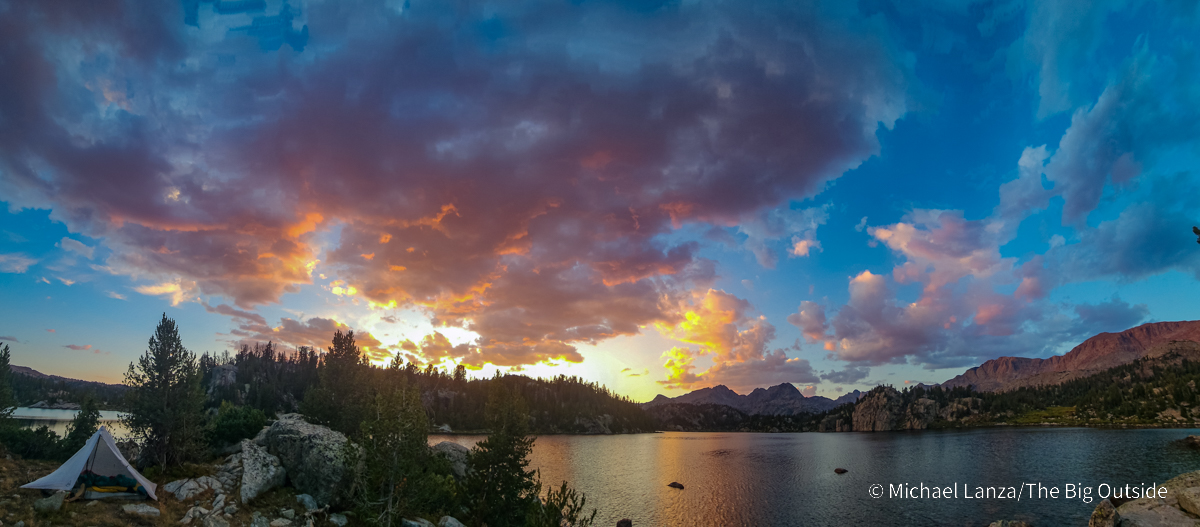
Llama guy points me to an “awesome” campsite not much farther along the shore of Lower Cook Lake, at 10,149 feet. So, I hike in the direction he pointed and find it, a short walk from the water and a bit higher than lake level, with a panorama of my surroundings that spreads a big grin across my face.
A calm evening settles in. The sun ducks below the horizon, lighting up the mountains, the cliffs that plunge straight into the lake on its far side, and the fluffy pillows of broken clouds reflected in the lake—treating me to an inspiring first night sunset.
See “The 10 Best Backpacking Trips in the Wind River Range”
and “The Best Backpacking Trip in the Wind River Range? Yup.”


Backpacking Solo
I leave my camp at Lower Cook Lake in the cool, dead calm of early morning, under a sky so blue it looks Photoshopped. Hiking the trail rising gently but steadily toward Upper Cook Lake, I meet a couple coming down. They had camped at the upper lake. “It’s pretty on the other side” of the Cook Lakes Loop, he says, “but there are three guys over there. There’s no one here.” With a nod of his head in the direction I’m walking, he says, “There’s a couple of moose up there, a bull and a cow, so look out for them.”
That couple will be the only people I see today.
Over the more than 30 years that I’ve taken long walks in wilderness for my livelihood, I’ve certainly backpacked solo more times than I could estimate; but I long ago grew to not enjoy it. I like having company (and I’m fortunate to have many good friends and a family who are regular, highly competent partners in the backcountry). And once I became a dad, when I went out alone on a trip, I would miss my family so much that I’d get the hike done as fast as I could and get home. I eventually stopped backpacking solo.
Like what you’re reading? Sign up now for my FREE email newsletter!

Fast forward two decades. My kids are young adults and they and my wife like to hike with me, but they can’t go as much as I do. I had a good friend lined up for this trip; in fact, we had intended to hike the entire CDT through the Winds over seven days, with a variation that would bring us through the Cirque of the Towers. Then an injury sidelined him, and a wildfire closed the Green River Lakes area at the north end of the CDT in the Winds, forcing me to start at Elkhart Park.
I had been looking forward to this trip for months. I didn’t want to bail out on an opportunity to walk six days through the Winds, mostly on trails new to me, including a significant piece of the CDT.
So here I am. Alone. But this time, I’m okay with that—even excited about it.
Before long, I emerge from the forest into a rock-strewn meadow overlooking Upper Cook Lake—and the scene slams me to a stop as if those moose had darted across the trail in front of me. Larger and even prettier than Lower Cook, the upper lake lies in the embrace of tall granite walls, glacial erratic boulders of all sizes, grassy lawns, mud flats—and in the distance, daunting mountains on the Continental Divide. It’s a natural rock and water garden that looks as if Frank Lloyd Wright might have had a hand in designing it.
I walk around the far shore and turn up a use trail leading toward Wall Lake, which lies even higher up this valley. It grows intermittently faint and I repeatedly lose and regain the path and soon reach Wall Lake. Narrower but longer than Upper Cook, Wall Lake pokes a watery finger into the bellies of 12,000-foot peaks and, apropos of its name, sits at the foot of a towering cliff at the lake’s south end—and other walls along its length. A nice spot for a solitary campsite.
Less than an hour later, I’ve backtracked to the CDT, where I turn south without breaking stride, cruising along a good footpath over the rolling terrain of this plateau, gawking at the scenery in every direction—and everywhere I look, seeing no one.
Plan your next great backpacking trip on the Teton Crest Trail, Wonderland Trail,
in Yosemite or other parks using my expert e-books.


The Meaning of Wilderness
Wilderness means different things to different people. But in its ideal state, it at least offers opportunities for the solitude that’s implied in The Wilderness Act of 1964, which defines wilderness as “… an area where the earth and its community of life are untrammeled by man, where man himself is a visitor who does not remain.”
Finding that kind of deep solitude isn’t easy—and that’s the point. It shouldn’t be. Its rewards are the kind that feel more satisfying when earned through meaningful effort.

But finding solitude is also not a fool’s errand. As I write in this story describing what I’ve found are the conditions that often ensure that you’ll share your wilderness with few other people: The truth is that there are many ways to find backcountry solitude because the odds work in your favor. Most wilderness trails have few or no people on them most of the time. You simply have to understand where and when to look for it—and stop thinking like everyone else thinks.
And that’s exactly what I’m doing out here, walking for six days through Wyoming’s Bridger Wilderness—while seeing just a fraction of the Bridger’s 426,000 acres (nearly as large as Kings Canyon National Park) within the much larger Wind River Range. The Bridger was among the very first federal wilderness areas designated by the 1964 law. Lucky for us that it was.
On the CDT on my second afternoon, sweating hard under the alpine sun of early September, I find myself repeatedly thinking, “There’s really no one out here.”
Hike “America’s Top 10 Best Backpacking Trips”
and “The 12 Best Backpacking Trips in the Southwest.”

By late afternoon, I drop my pack to camp near yet another small, anonymous lake along the CDT. And I have a feeling of crossing another invisible or psychological boundary of sorts, between well-known corners of the Winds that seem to pull people in like paper clips to a magnet, and this “other” Wind River Range, which seems to remain very lightly traveled. The wind blows into early evening, like last night, then calms.
When I step outside the tent long after dark, a light flurry of wildfire ashes floats through my headlamp beam—another little reminder that I’m alone deep in wilderness and my shuttle back to civilization will arrive in four days at a trailhead far ahead of me. I have much walking to do while being pursued, at least potentially, by fire, rain, and even snow.
Join now to read all of this story, including my expert tips on planning this trip,
and ALL stories at The Big Outside, plus get a FREE e-book!


The Continental Divide Trail Through the Winds
I hit the trail by 7:30 on my third morning, the early-morning air chilly like yesterday. I love hiking early—for the cooler temps, the quiet, and how the low-angle, high-contrast light makes the landscape look deeper and larger. And when I want to cover some miles, I like that I’ll knock off eight or more before lunch. But as soon as the sun hits me as I’m walking up to Hat Pass, at 10,848 feet, I shed my light fleece hoody for a sun shirt. (See my favorites here.)
Again, I’m walking through a landscape of boulder-filled meadows and lakes of all sizes rippling, shimmering, or offering a perfect reflection of a backdrop of mountains. The sunlight on the ground looks more yellow than normal and the sun in the sky more diffused: signs of the smoke blowing south from the wildfire in the northern Winds.
I can help you plan this or any trip you read about at my blog. Click here to learn how.

Then, at a shallow and broad creek crossing, I run into three backpackers from Texas, Mike, Dave, and Eric—the first people I’ve seen since that couple on the Cook Lakes Loop early yesterday morning. We talk as I’m filtering water. Like me, they had planned on hiking from Green River Lakes to Big Sandy on the CDT but rerouted to start at Elkhart because of the fire. We discover that we’re all climbers and, it turns out, we have mutual friends. Small world. After leaving them, I hike past three young women at Bobs Lake.
As the miles roll by, I reach a firm conclusion: The Continental Divide Trail through the Wind River Range exceeds even the high expectations I had for it. Imagine all the elements of an idyllic hike in mountains: a landscape that seems sculpted from a mountain range-size block of granite, with vast basins, lakes everywhere—and I mean absolutely everywhere, perhaps more of them unnamed than named—and serrated peaks joined at the shoulders in an endless row that seems to claw at the sky.
That’s the CDT through the Winds. Very much like the John Muir Trail through the High Sierra—but on large parts of it, without the JMT’s level of human presence.
Find your next adventure in your Inbox. Sign up now for my FREE email newsletter.


A 50-Year-Old Memory of Wilderness
As the sun arcs closer to the horizon, I turn off-trail toward yet another medium-sized lake (“medium” roughly defined as I can see all of it, but it’s too big to take an evening stroll around it), walking downhill across dry, grassy meadows littered with rocks, and find flat ground on the lee side of a granitic outcropping to provide some wind break, with a view of the lake and a short walk to it for water. Perfect. Thunderstorms never materialize. The wind, again, blows hard into early evening, but calms after around 7 p.m.
Not long after setting up camp, I hear a voice behind me apologizing for disturbing my solitude; he’s come to get water from the lake. I invite him over and point to the easy access point where I got water. We make introductions and quickly discover we both grew up in Massachusetts in cities 30 minutes apart and only got into hiking, climbing, and backcountry skiing as young adults. Peter says he now lives in Grand Junction, Colorado—and after a few minutes of small talk, he launches into a story that fully captivates me, about he and a buddy skiing in February 1976, when Peter was 28, from South Pass in Wyoming the length of the Wind River Range and across Yellowstone. Thirty-one days they were out—they had cached food in a couple of spots along their route—and never saw even a single ski track other than their own.
What a memory to have for a lifetime.
See “The 10 Best Backpacking Trips in the Wind River Range”
and “The Best Backpacking Trip in the Wind River Range? Yup.”

Now well into his 70s, though his face and physical condition don’t betray his age, he’s out here for seven days backpacking solo. Maybe Peter’s a model for my future (although I hope that all of my good backpacking partners and I will continue to do this together).
With a nod toward my Garmin inReach on a rock beside me, he acknowledges that he’s also carrying one to message his wife nightly. I tell him that I’m sending nightly messages to my wife; my 25-year-old son, also very experienced in the backcountry, who’s monitoring detailed weather reports and wildfire and smoke conditions to let me know what’s coming my way; and a good friend of mine who’s a volunteer search-and-rescue (SAR) team leader and will know who’s responding to any emergency out here and how. My messages include my location coordinates, so those three people receiving my messages know precisely where I’m camping every night.
I say, “You didn’t have one of these little things back then.” He laughs and responds, “No, we had no contact with anyone that entire time.”
What a stark difference in our world—and in the reality and very concept of wilderness—since Peter and his friend skied the length of the Winds and Yellowstone almost 50 years ago: For 31 days, they heard from no one, and no one heard from them.
We no longer live in a world where we would ever have to isolate ourselves from communicating with other people, no matter how remote we are. Peter or I can push a button to request a rescue and he, like me, probably has rescue insurance.

How alone is any of us, even out here in the middle of the Wind River Range?
Of course, I can choose not to carry a device that enables me to text with people, transmit my location, and call for a rescue. But I’ve lived through a few backcountry emergency situations—including my own serious climbing accident, when my son, who was climbing with me that day, was able to quickly call for the local SAR team to carry me out because we had cell service on that cliff in Utah’s rugged Little Cottonwood Canyon; and a past climbing accident, when a good friend died as we worked in vain to resuscitate him, in a time before cell phones and mass-market, GPS-based devices. The 30-year anniversary of that tragedy occurred on the very day I began this backpacking trip.
Read all of this story, including my tips on planning this trip,
and ALL stories at The Big Outside, plus get a FREE e-book! Join now!

Yes, Peter’s ski adventure was unique in many ways, not least for their complete isolation from civilization—an experience that may now be impossible to fully replicate, just as we cannot truly know what it was like to live as a mountain man in the U.S. West two centuries ago. Still, I believe that for anyone reluctant on principal to carry technology that increases their safety margin in the backcountry, it takes no more than one life-or-death situation involving someone they care about to change their mind.
After our enjoyable conversation, Peter gets his water and returns to his camp. Meeting him brings the tally of people I’ve seen today to nine.
The sunset burns a deeper yellow, reflected in the lake’s wind-rippled surface, where 10 ducks paddle in seemingly choreographed movements, bobbing their heads underwater for food. The moon at dusk glows an unnatural yellow. Smoke.
Planning a backpacking trip? See “How to Plan a Backpacking Trip—12 Expert Tips”
and this menu of all stories with expert backpacking tips at The Big Outside.


Ice Crystals, Coyotes, and Elk
After the chilliest night I’ve had so far out here, I rise on my fourth morning to find a little condensation inside the tent due to the cold, very still air, and frost on my bear canister. A moment after finishing my tea, ice crystals form in the bottom of my mug.
Somewhere nearby, coyotes yip. A little while later, the bugling of an elk pierces the calm, crisp air.
Even backpacking solo, I’m as excited and happy walking down a trail as when I’m with other people. In fact, I may be paying sharper attention to my surroundings because I’m not distracted by conversation.
I hike past the same three young women backpackers again, packing up their camp on a lake not far beyond where I camped. A couple of hours pass before I see more people, a couple from Colorado in the Winds for the first time and these experienced backpackers are impressed by what they’ve seen. Later, I walk by three young backpackers and then a solo guy who just got through a section of the Wind River High Route that I remember well.
Want my help planning any trip you read about at this blog?
Click here now for expert advice you won’t get anywhere else.
See all stories about backpacking in the Wind River Range at The Big Outside.
The Gear I Used See my reviews of the outstanding backpack, tent, sleeping bag, lightweight fleece hoodie, down jacket, sun shirt (Black Diamond Alpenglow Pro Hoody), trekking poles, air mattress, and stove that I used on this trip.
Find the best gear, expert buying tips,
and best-in-category reviews at my Gear Reviews page.
Not sure this is for you? See “How to Know How Hard a Hike Will Be,” “How to Plan a Backpacking Trip—12 Expert Tips,” “Bear Essentials: How to Store Food When Backcountry Camping,” and this menu of all stories offering expert backpacking tips at The Big Outside. Like many stories at this blog, most of those require a paid subscription to read in full.
Want my help planning the details of this trip, including an itinerary appropriate for your group? See my Custom Trip Planning page to learn how I can help you plan this or any trip you read about at this blog.
I do t suppose you ran into any wilderness winos on this trip?
Hi Mark! Great to hear from you. No, I did not, but as you know, wilderness winos are a rare and special species, generally only found in areas where a horsepacker has carried in an adequate supply of spirits!
great photos and story. I’ve done nearly all of that. Cook L, Wall, and into Titcomb. Dream to Lee L and Bonneville, and a few routes from Skull to E. Fk, Washakie and Texas Passes. 25 years and there’s always something new.
Thanks, Bill, I appreciate the kind words and you sharing your story. It’s an amazing area of the Winds.