
By Michael Lanza
Below a deep gash in a 50-foot-tall cliff of golden sandstone, shaded from the low, late-afternoon sun of early spring, I scramble up a steep slab using in-cut holds carved into the soft rock. Ten or 12 feet off the ground, I pull myself over the lip of a ledge to peer into a narrow cut in the earth, a hidden geologic oddity that lures in a certain type of hiker for one reason: because it’s barely wide enough for humans to squeeze through. And I have to smile.
I’m grinning first of all because I’ve found just what we had hoped to see. Water sometimes pools in a couple of potholes near the mouth of this slot canyon, and the air temperature today feels a little too cool to soak ourselves in cold water. Today, though, the sandy-bottomed, giant stone teacups are dry. But secondly, touching me on a more personal level, this canyon’s entrance looks much as I remember it from the first time I hiked through here, 16 years ago this month.
In less than two hours, my impression of this place will be almost completely remade.
“Yup, it’s dry,” I tell my gang waiting on flat ground below me. So my Boise friend Justin Hayes positions himself on a small ledge partway up the slab to spot the four kids as they take turns scaling it. Then my son, Nate, 12, and daughter, Alex, 10, and Justin’s son, Riley, who’s almost 12, and 10-year-old daughter, Kellan, all scrabble up the in-cut steps and walk into the slot canyon with wide eyes and gaping mouths.
And the six of us plunge forward up Peek-a-Boo Gulch, a well-known, quarter-mile-long, and very tight slot canyon in southern Utah’s Grand Staircase-Escalante National Monument.
 Hi, I’m Michael Lanza, creator of The Big Outside. Click here to sign up for my FREE email newsletter. Join The Big Outside to get full access to all of my blog’s stories. Click here for my e-guides to classic backpacking trips. Click here to learn how I can help you plan your next trip.

Our foray into Peek-a-Boo Gulch comes on the second day of a weeklong family trip to what might be called Utah’s “parks in the middle.” Between the world-famous destinations of Moab (base camp for Arches and Canyonlands national parks) to the northeast and Zion National Park to the southwest sit Bryce National Park and two lesser-known wild lands harboring a constellation of slots, arches, natural bridges, and broad canyons with soaring walls of red rock, Capitol Reef National Park and the Grand Staircase-Escalante.
I’ve planned seven days of hiking within these three parks. Some canyons will be new to all of us, while a few I’m revisiting after a hiatus of nearly two decades: Peek-a-Boo, its neighbor Spooky Gulch, and another classic Escalante trip, backpacking Coyote Gulch.
I want the kids to see these places because, if memory serves well, I’m confident these canyons will send them into paroxysms of excitement. So far, I’m right. But I’m also wondering how true my memories will be to the on-the-ground reality of places I have not seen in many years.
Memory is an unreliable recording device. Sometimes it gets details mostly right, but at other times it proves not so good with accuracy. Occasionally, returning to the site of fond recollections proves disappointing, if the place doesn’t measure up to your faded mental image of it—not uncommon if you’ve seen a lot of impressive scenery over the years since that first visit.
I wondered how differently I might see these corners of the Escalante today. If how poorly I fare whenever I play a memory game with my kids offers any clue, my mental pictures of these places may be in for a major edit.
Get the right pack for you. See my picks for “The 10 Best Backpacking Packs”
and the best hiking daypacks.


Chimney Rock, Lower Calf Creek Falls
We started this week with a morning dayhike of the 3.5-mile Chimney Rock Loop in Capitol Reef National Park, with sweeping views of the red and white cliffs and towers of the Waterpocket Fold, a nearly 100-mile-long jumble of sandstone. Then we drove south along UT 12, one of the most scenic roads in the country, to camp at Calf Creek Recreation Area, where the kids explored the year-round creek bouncing loudly through the campground and rocky ledges nearby (requiring one non-technical and, fortunately, injury-free rescue).
The next morning—a frosty one, with the temperature about 15° F when we got up (the rest of the week would get warmer)—we hiked the 5.5-mile, out-and-back trail from the campground up the high-walled canyon of Calf Creek to Lower Calf Creek Falls. A boisterous column of water 126 feet tall, it falls in braids from a notch in a mineral-streaked sandstone cliff. Later in spring, we would have taken a dip in the sprawling pool at the waterfall’s base; but despite the warm sunshine, a blustery, cold wind discouraged that idea. By late afternoon, we started hiking toward Peek-a-Boo and Spooky.
Find your next adventure in your Inbox. Sign up now for my FREE email newsletter.
Now, in Peek-a-Boo Gulch, we pull ourselves over short pour-offs and duck through natural arches. We twist and contort our bodies to squeeze between wildly curved walls that frequently narrow to just inches wide. Justin and I shove daypacks ahead of ourselves because we wouldn’t fit through the claustrophobic passage wearing them. Even the kids marvel at the delicately sculpted rock formed, incongruously, by the sudden violence of flash floods that follow rainstorms. Small as our children are, they struggle to push themselves through many spots—and the more confined it gets, the more animated they become. We’re wading through a flash flood of superlatives.
“Wow, this is so cool!”
“That’s amazing!”
“Awesome!”
Like this story? You may also like my “10 Tips For Getting Your Teenager Outdoors With You”
and my very popular “10 Tips For Raising Outdoors-Loving Kids.”


After about 40 minutes of trying to move like water flowing uphill, we emerge from the top end of Peek-a-Boo and follow an unofficial trail of footprints and cairns across about a mile of desert plateau, and then drop into the upper end of Spooky Gulch. And Spooky proves tighter than I remember—tighter even than Peek-a-Boo—with a boulder jam that I have no recollection of. The kids stare in awe at chockstones and logs jammed between the walls 20 feet overhead, indicating the high mark of a previous flash flood.
Continuously and crazily narrow, this stone corridor forces us to edge through sideways for most of its roughly quarter-mile length. In a few spots, I find myself contemplating the unsettling prospect of my head getting stuck. It brings some reassurance that I don’t recall my cranium jamming between these walls my first time through, years ago. And I’d probably remember that.
It’s nearly 8 p.m. by the time we return to our campsites at the Calf Creek Recreation Area, where my wife, Penny, and Justin’s wife, Cyndi, who drove down today, are waiting. Everyone’s hungry and tired but still tingling with excitement from the day’s adventures. Nate and Alex separately come and plop onto my lap as we sit around the campsite long after dark. Justin tells me his opinion of Peek-a-Boo and Spooky: “That was a 10, a total win.”
I can help you plan the best backpacking, hiking, or family adventure of your life. Click here now to learn more.


Backpacking Coyote Gulch
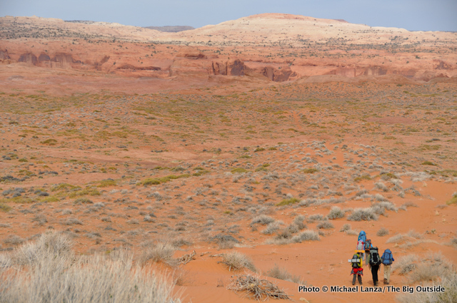
“Well, I think we found Crack-in-the-Wall,” Nate announces as the eight of us stand at the brink of a sandstone cliff dropping straight down more than 50 feet.
It’s early evening on our third day in southern Utah. An hour ago, we started out from the Fortymile Ridge Trailhead in the Grand Staircase-Escalante, hiking with full backpacks across almost two miles of beach sand and slickrock formed from ancient, petrified dunes. At first glance, this cliff appears to offer no route to its base that wouldn’t involve rappelling. But the feature known as Crack-in-the-Wall actually provides a surprisingly easy descent, requiring only a little unexposed scrambling, a wide ledge traverse, and a squeeze through a slot about 100 feet long—too narrow to wear a pack through—that ramps gently down to the cliff’s base.
While Justin and I use a utility cord to lower the eight packs one at a time over the cliff to Cyndi and Penny below, the kids descend the Crack without needing any help. I can hear them gushing about it. Nate comes back up and announces to me, “I’m here to guide you.” When we finish lowering the packs, he leads Justin and me through the Crack. It is pretty darn cool.
Then we follow a path of boot prints in deep sand leading downhill. Before us stretches a breathtaking desert landscape of redrock towers and cliffs. The eye of Stevens Arch, some 220 feet across and 160 feet tall, looms above the Escalante River Canyon in the middle distance.
The trail deposits us in Coyote Gulch about a half-mile upstream from its confluence with the Escalante River in Glen Canyon National Recreation Area. Just before 7 p.m., in calm air at T-shirt temperature, we find a sandy beach campsite beside Coyote’s shallow but clear and steadily flowing creek. We adults pitch tents below walls painted in various hues of red streaked with black water stains and fire up stoves for a pasta dinner that will be a little crunchy with silt from the creek water. The kids play by the creek, launching sticks downstream that they bombard with rocks and mud grenades.
Plan your next great backpacking adventure using my expert e-guides.
Coyote Natural Bridge, Jacob Hamblin Arch
On our second day, we hike up Coyote Gulch, passing through a narrow chop the creek sliced through a rock wall. We pass a flume with curved walls and a series of waterfalls anywhere from three feet to about eight feet tall that crash over ledges into calm pools. We alternate between walking in sand and wading the typically ankle-deep creek. With a year-round stream here, trees and other greenery abound, a stark contrast against the burgundy cliffs.
After six miles, we pitch tents on the downstream side of Coyote Natural Bridge, a gaping hole big enough to drive a tractor-trailer through that the stream has bored through a 40-foot-tall sandstone fin. We have the big, sandy beach in the shade of the bridge all to ourselves. The kids are tired, having walked quite a bit against the stream’s current; but they spend hours, nearly till dark, playing in the water.

On our third morning, after just over an hour of hiking upstream, we reach a sweeping horseshoe bend in Coyote Gulch, beneath a wall some 200 feet tall that arcs overhead like a giant, standing clamshell, undercut nearly as deeply as it is high. The kids quickly discover it has amazing acoustics: We can yell a full three-word phrase and hear its distinct echo a second later.
Fresh tracks of bighorn sheep pepper the wet sand; they came through here either last night or early this morning. Just past the huge undercut we take a break below the 100-foot sandstone span of Jacob Hamblin Arch, one of Coyote’s highlights. Nate and I scramble up into the arch to pose for a photo, two ants in a massive hole in the cliff.
Coyote Gulch proves even better than memory. While never narrowing to slot proportions, the sheer walls at times loom close enough to give the impression of a deep, intimate canyon; and we frequently walk either in the creek or right beside it, magnifying that sense of intimacy. In other spots, the upper canyon walls spread a quarter-mile apart and rise up to 900 feet above the canyon bottom. In a sense, Coyote delivers a complete canyon-hiking experience, without any difficult spots, and with water for its length, but without you ever having to wade deep, cold water.
The trip’s last few miles, slogging up sandy Hurricane Wash, makes me glad we’re not out here on a hot day. The canyon walls in Hurricane begin sheer and tall but transform quickly to low slickrock domes offering no shade. Everyone has that end-of-the-backpacking-trip feeling that we’re ready to shuck off these packs. Still, I’m sure everyone, kids and adults, will carry some very positive memories of Coyote Gulch away from here.
After an hour-long drive back up Hole-in-the-Rock Road to the little, desert town of Escalante, we eat at a local restaurant and make an impromptu decision to drive to Bryce Canyon National Park, an hour away, to dayhike there tomorrow.
Explore the best of the Southwest. See “The 10 Best Hikes in Utah’s National Parks” and
“The 10 Best Backpacking Trips in the Southwest.”


Bryce Canyon’s Navajo Loop, Queens Garden, Peek-a-Boo Loop
Setting out on Bryce Canyon’s Navajo Loop/Queens Garden Loop at mid-morning on a brilliantly sunny, warm Friday can offer all the wilderness aesthetics of a trip to Albertson’s Supermarket. This is a popular trail—for good reason, with constant views of hoodoos, the multi-colored, limestone, sandstone, and mudstone spires that look like giant, misshapen candles, including the famous formation called Thor’s Hammer.
But once turning onto the park’s Peek-a-Boo Loop, we drop most of the crowds without sacrificing spectacular views—like the stretch of trail below the Wall of Windows, a row of cliffs with large holes eroded through them.
I’ve been to Bryce before but had never walked the Peek-a-Boo Loop. Now I see I was missing perhaps the park’s finest trail.
Read all of this story, including my expert tips on planning this trip, and ALL stories at The Big Outside, plus get a FREE e-guide. Join now!

Memory does often fail us—or just distorts reality. But revisiting a favorite place, at a different time in your life, forges new memories to replace the old—especially if you go with different people or your children, anyone who gives you the gift of seeing a place anew through their eyes. Now my kids are creating their own memories of these Utah parks—memories doomed to be flawed but joyful. Maybe they will return one day with their kids. Maybe the highest purpose of memories is ultimately to pass them down through generations, each handler of them altering the content with each handoff, but still preserving some precious piece of these gems.
On our trip’s last day, back in Capitol Reef again, we hook up with my friend Steve Howe of Redrock Adventure Guides for a four-hour hike. From near the park campground, he leads us into Cohab Canyon. We detour briefly up a short slot canyon, then continue down Cohab and up a side trail to Fruita Overlook, with its panorama of the park’s formations above the Fremont River Canyon. Then Steve takes us up the Frying Pan Trail. We soon head off-trail, ascending a sandstone ramp, scrambling around the heads of deep, vertiginous slot canyons, walking over slickrock domes. Finally, we reach a cliff-top overlook of the Waterpocket Fold, a spot Steve calls one of the best views in the entire park.
And it is spectacular—reaffirming my impression that Capitol Reef is a stunningly gorgeous landscape and one of our most underappreciated national parks. This is perhaps my fifth trip here, and it always measures up to my past recollections. I guess my memory still proves reliable once in a while.
Get my help planning your backpacking, hiking, or family trip and 30% off a one-year subscription. Click here.


NOTE: See my previous story about dayhiking, slot canyoneering, and backpacking in Capitol Reef National Park.
Tell me what you think.
If you enjoyed this story, please consider giving it a share using one of the buttons at right, and leave a comment or question at the bottom. I’d really appreciate it.
Great read as usual. I wonder if you could comment on the relative merits of going your direction vs the opposite—coming up crack in the wall to finish at forty mile ridge—in coyote gulch. Thanks.
Thanks, Michael. Fair question. There are instances where I think it’s easier to scramble up a minor technical route than to scramble down it. In the case of Crack-in-the-Wall, I think the scrambling itself is easy enough to do in either direction. The harder part would be that you’d have to haul packs up that short, two-section cliff, rather than simply lowering them down it. Again, that’s certainly not impossible or terribly difficult (although I might want to have leather gloves for hauling a pack using a thin utility cord). Some people for whom relatively easy scrambling might feel challenging might prefer going down it than up.
Plus, the “trail” of sorts from the bottom of Crack-in-the-Wall to Coyote Gulch is very sandy, which would be more strenuous going up than down. By camping in lower Coyote Gulch, near the trail to Crack-in-the-Wall, you’d have a shorter last day to finish the trip than hiking out from one of the last camps with good water higher up in Coyote Gulch. But then, you’d have to have a vehicle that can handle to road to the Forty Mile Ridge Trailhead waiting for you, too.
That pretty much sums it up. Thanks for the question.
We were just in Grand Staircase Escalante and Capital Reef. I enjoyed your story and especially the legacy you have created for your children. I can only hope the children of our grandchild will enjoy the vast wilderness of Southern Utah.
Thank you, Dorothy, and I share your hope that future generations will still have a natural world they can still enjoy. If our generation is willing to ensure that.