By Nate Lanza
The relentless midday sun of this harsh desert seems to bake the parched earth and all the animals upon it—with its greatest cruelty reserved, it seems, for me—as I pound down the biggest descent on the Beamer Trail, one of the most remote paths in the Grand Canyon. I’m racing the pain in my joints and the building heat in my head, as well as the steadily rising heat of the day, toward my salvation: a sandy beach on the shore of a refreshingly frigid and uncharacteristically clear Colorado River.
Reaching it, I escape my pack and shoes as though they’re on fire and flop into the crystalline waters of a shallow eddy, where the river and I rest together for a few blissful seconds, until I rise in a spell of cold-induced euphoria to dash gleefully around my new sanctuary. Unfortunately, my reverie proves short-lived: Eight miles remain to our next camp, and it’s already noon.
It’s the third day of my second backpacking trip in the Grand Canyon, and it’s already going rather like the first—at age 10, and my first time carrying a real backpacking pack—which, as I remember across 16 years of recollective haze, involved an unexpected amount of pain. The canyon’s “inverted mountain” profile earns its reputation for brutalizing hikers; it harbors as much elevation gain and loss as the most difficult of Colorado’s 14ers combined with a much drier, hotter landscape, highly erosive soils that often crumble underfoot, and rocky, rugged trails subject to yearly destruction during summertime monsoonal rains. These trails and the surrounding slopes conjure the shattered appearance of the rubble of buildings flattened by earthquakes or bombs.
 Hi, I’m Michael Lanza, creator of The Big Outside. Click here to sign up for my FREE email newsletter. Join The Big Outside to get full access to all of my blog’s stories. Click here for my e-books to classic backpacking trips. Click here to learn how I can help you plan your next trip.

But in exchange for the punishing terrain and climate, the canyon invariably rewards those willing to endure its inhospitality with vast and colorful desert vistas unmatched anywhere else on Earth.
On our first day, we descended the Tanner Trail—which we refer to only as “The Tanner,” as though it were some ancestral deity hell-bent on causing us suffering—where the Grand Canyon fully displays her hostility toward creatures with legs. Starting later than the rest of the party (on account of a rushed schedule—technically, three very satisfying days of skiing right before this trip that resulted in me arriving at the trailhead with all the accoutrements for a five-day backpacking trip scattered haphazardly around the back of my car). But once hitting the trail, my cousin, Marco Garofalo, and I quickly caught up to father-son duo David and Sam Ports picking their way gingerly down the stacked and constantly rolling rocks of The Tanner.
After the Grand Canyon, hike the other nine of
“America’s Top 10 Best Backpacking Trips.”

Sam immediately turned to us with a crazed look and summed up his feelings: “This trail SUCKS!” Indeed, a higher power would struggle to construct a trail better-suited to sending the unwitting backpacker tumbling deep into the canyon under the weight of five days worth of supplies, as my dad, Michael (the creator of this blog), almost did when a large boulder slid downhill under his weight (and he managed to step off it in the nick of time).
Yet despite an introductory mile that almost warrants a technical rock climbing grade, the Tanner flattens out twice during its 4,700-foot descent to the river to provide mellower hiking and expansive vistas overlooking terrain visited far less often by hiking parties than the well-traveled trails further downstream. To our right looms the South Rim, buttressed by colossal cliffs of Redwall Limestone; David and I debate the height of the wall visible to us, which turns out to be nearly 4,000 feet.
The bottom of the trail delivers us directly to that night’s camp, which provides a perfect eddy for cold plunges and gorgeous views of the canyon walls and stars above us. I stay up late to shoot photos of the stars before laying my pad out on a rock just above camp, soaking in the views as I drift off.
Like what you’re reading? Sign up now for my FREE email newsletter!


The Confluence
Our second day dawned cloudy as we packed up camp to head to the confluence of the Colorado and Little Colorado rivers. I elected to sleep in and leave camp a bit later than everyone else, and in doing so, made a painful mistake: neglecting to pace myself for the rigors of a five-day trip. I took off at a fast pace and caught the group quickly, but at the price of further exhausting my already-worn legs.
After a few miles of flat, easy hiking, the Beamer Trail climbed steeply to a shelf nearly a thousand feet above the river and proceeded to weave between sections of flat, easy walking and diving into deep, dry washes where routefinding proves convoluted and footing treacherous. I arrived at camp—a gorgeous alluvial fan pouring into the river, seldom-used by backpackers (spots like these are one of the many perks of having a professional trip planner creating the itinerary)—with legs even more worn than yesterday.
I’ve helped many readers plan memorable backpacking trips in the Grand Canyon and elsewhere.
Want my help with yours? Click here now.

Another evening filled with cold plunges and laughter as the eight of us—those already mentioned plus husband-and-wife friends Mark and Lisa Fenton and another longtime regular in this backpacking troupe, Todd Arndt—reached the state of wondrous and free socializing produced only deep in the wilderness by well-exhausted bodies that still retain the energy to laugh well into the evening.
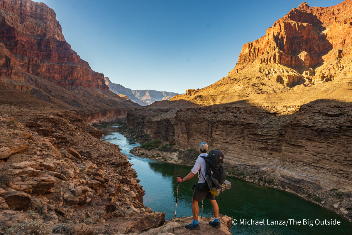
The next morning, Todd and my dad (who hiked to the confluence after we arrived yesterday) took off early, ahead of the rising heat, while the rest of us hiked to the confluence to witness a rare sight: the brightly pearlescent blue of the Little Colorado merging with a shockingly clear Colorado River. The transparent Colorado, normally an opaque and ruddy brown much of the year, both proved a boon to our trip and portended doom: while we can easily filter water from the river without the mucky silt clogging our filters, the Colorado flows so clear because it flows so much lower than it should at this time of year, on account of the worst snow year ever recorded in Colorado history.
Join now to read all of this story, including expert tips on planning this trip,
and ALL stories at The Big Outside, plus get a FREE e-book!

I first visited the Grand Canyon 16 years ago as part of my dad’s book project to take my younger sister and I, in one year, to numerous national parks impacted by the climate crisis. I vividly remember the ruddy brown of the Colorado as it flowed below us; a desert river bloated and choking on spring runoff overtopping its usual banks to move megatons of sediment downstream. In his book about our family’s experiences, my dad details the effects of a warming climate on the Grand Canyon: mainly, aridification, where less snowfall in the mountains of Colorado leaves less water in the mighty Colorado and the reservoirs it feeds.
Sixteen years later, these predictions are coming true. The Bureau of Reclamation recently announced that Lake Powell, upstream of Grand Canyon, faces the existential threat of minimum power pool by August of this year; such an event could seriously damage the dam. To combat this, Reclamation will take the extraordinary steps of both reducing the water output to Lake Mead (which will drop the power generated by the Hoover Dam, supplying Las Vegas, by up to 40 percent) and moving up to a million acre-feet of water downstream from Flaming Gorge reservoir, one of the last large reservoirs in the system with capacity remaining to do so. Despite the direness of the situation, elected and other leaders from the Colorado Basin states and the federal government have yet to agree on a new framework to eliminate overconsumption of water from the river.
See “10 Epic Grand Canyon Backpacking Trips You Must Do”


Escalante Route
I shoulder my pack, clothes still dripping from my frolic through the sanctuary eddy and resume trotting away at the 14 miles (including my walk to the confluence and another minor detour) that I must cover on our third day. After the excursion to the confluence, which added about a mile round-trip without packs, our group split up: Marco and I proceeded ahead to catch my dad and Todd at the junction with the Tanner, where our group camped our first night; the rest of the group will sleep at my swimming hole and hike back up the Tanner in two day’s time.
By that afternoon, Marco, Todd, my dad and I are back at Tanner Beach, waiting out the heat of the afternoon swimming and napping until evening, when we race across the first three miles of gently rolling to flat terrain on the Escalante Route to a camp at the dry Cardenas Creek, just further from the river than the gorgeous sandy beach that we found already occupied. Arriving late, it’s all we can manage to eat our dinner before collapsing into sleeping bags under a dark sky riddled with stars.
Click here now to plan your next great backpacking adventure using my expert e-books.

Gear Tips
Trekking poles are indispensable for this route’s steep descents and ascents. See “The Best Trekking Poles” and the stories “How to Choose Trekking Poles” and “10 Best Expert Tips for Hiking With Trekking Poles.”
See all stories about backpacking in the Grand Canyon at The Big Outside.
An avid backpacker, dayhiker, backcountry and resort skier, climber, and trail runner—and Michael Lanza’s son—Nate Lanza has spent an inordinate amount of time outdoors since he was a preschooler and has two decades of experience on wilderness adventures. He has joined The Big Outside and will be writing stories about trips, reviewing gear, and continuing to spend as much time in the backcountry as he can.
Great story, Nate! Glad to hear you will continue to live the dream.
Cheers!
Thanks Jennifer! Cheers to you too, and I hope Ted is doing well and also living his dream!
50 years ago, I did this same hike (plus a bit further up the Little Colorado River) which was also my second trip to the Grand Canyon.Back then there were very few people hiking “off trail” in the Grand Canyon and I suspect the trails are a bit more established now, I’ve been hiking on the Colorado Plateau ever since, recently doing 30 day self supported trip on the Navajo Nation. Canyon country can’t be beat!
That sounds incredible! Yes, I’m sure there were far fewer people way back then, though we still only saw about a dozen other backpackers in the four days before we reached the Tonto Trail. The trails are certainly better established but still rough at many points. Canyon country sure can’t be beat, and I feel lucky to be able to visit it frequently from Salt Lake!
been to the canyon a dozen times mainly in the corridors. most aggressive trip was the bill hall to thunder river, tapeats creek down to the colorado, back the same way. nearly killed me, seriously was concerned I wouldn’t make it out alive. so I am awed by your trips and my body is in pain just reading your stories!
Yes, the canyon isn’t easy via any trail descending into it. I’ve also backpacked the Thunder River-Deer Creek Loop, an extension of the route you hiked down and back up. It has some of the best waterfalls in the entire canyon. Thanks for sharing your story.
first time in the canyon was in 1953 (?) on a route 66 road trip with the folks. dad and I hiked down to the supai tunnel and back up. didn’t realize at the time what an iconic experience the whole trip was.
went back on a college road trip (in a 1967 VW bus!) in 1971 and met a former welsh boy scout (there’s a formal name guy those guys that I can’t recall. do you know?), a real serious competitive guy. we hiked down the south kaibab to the river, crossed the black bridge, checked out phantom ranch, crossed back over the silver bridge and slept overnight on the banks of the colorado river. no campsite, no nothing, just cowboyed on the beach. back up the bright ängel the next day. hard hike and I was a college boy.
then the bill hall. crushed and humbled.
but I keep going back. I can’t stay away. and I always think about teddy roosevelt. and john wesley powell.
Good memories to carry through life.