
By Michael Lanza
I stare at the backpack on the ground in front of me. At 85 liters, with every milliliter of it stuffed with about 60 pounds of gear and food, it looks like something that should be lowered by a crane into a container ship rather than attached to a person’s back. If it had legs, teeth, and an appetite for meat, I wouldn’t stand a chance.
In fact, standing at the Sawtooth Pass Trailhead at 7,820 feet in Sequoia National Park, looking up at our imminent ascent to 9,511-foot Timber Gap, I’m thinking the chances that I’ll have an easy time of it are very, very slim. Probably like most parents, before I became a dad I had absolutely no idea how much heavy lifting was involved.
With no small amount of dread, I heft my pack onto one bent knee, slip an arm through a shoulder strap and turn myself until the pack rests heavily on my back. Then I straighten up, feeling like I’ve already surrendered points at the outset of a wrestling match against a formidable opponent. This backpack and I are fated to spend a lot of intimate time together over the next six days.
And of course, this is all my doing.


I wanted to take my kids on their longest backpacking trip to date. I knew they were ready for it, and I liked the idea of exposing them to the shift in mindset that occurs after you’ve been on the trail for more than a few days. But our son, Nate, 12, and our daughter, Alex, 10, still do not carry their full share of gear and food. So I figured our limit was six days. But even with the lightest tents and other gear, fitting some 50 pounds of food inside two adult backpacks required some aggressive shoehorning. My wife, Penny, is carrying the heaviest load she has shouldered in years, and Nate eagerly accepted more than he’s ever carried, including our necessary third bear canister. Still, much of that 50 pounds of food ended up in my pack.
I’ve also been eager to backpack with my family in Sequoia, in the southern High Sierra, home to many of the highest mountains and one of the biggest chunks of contiguous wilderness in the Lower 48—a pristine and incredibly photogenic land of razor peaks and alpine lakes so clear you could stand on the shore and read a book laying open on the lake bottom. Hearing about our plans for a nearly 40-mile loop from the park’s Mineral King area, Penny’s brother, Tom, and his 18-year-old son, Daniel, decided to join us.
Find your next adventure in your Inbox. Sign up for my FREE email newsletter now.
While I’ve thru-hiked the John Muir Trail through this part of the Sierra and explored other corners of it—including a rugged, partly off-trail, 32-mile hike in the John Muir Wilderness—this would be my first deep foray into the backcountry of Sequoia, our second national park (designated 18 years after Yellowstone and a week before Yosemite, although the latter had been protected in 1864 as a public trust of California).
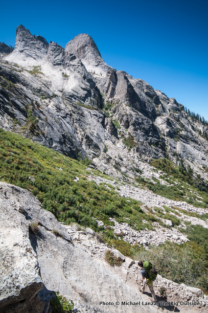
With my burly pack compressing my middle-aged spine, we start hiking at mid-morning in classic High Sierra weather: beneath a cloudless, blue sky, with the temperature in the low 60s and a breeze that’s very possibly saving me from heat exhaustion as we plod up through dozens of switchbacks on a sunbaked mountainside. Still, even in these pleasant conditions, within minutes, sweat pours from my head like a fountain.


Redwood Meadow Grove and Bearpaw Meadow
“I just startled a black bear about a quarter-mile back down the trail,” a backpacker tells us.
It’s late afternoon on our first day, and we’ve pitched tents in a spacious campsite in the forest by Cliff Creek, north of Timber Gap. The backpacker, just passing through, saw the bear on the trail we’ll hike tomorrow morning. It reminds me of what the ranger at the Mineral King ranger station told us when we picked up our permit this morning: This past winter saw the lowest snowfall in recorded history in Sequoia National Park, one fallout of which was less natural food sources for bears this summer—making them particularly aggressive in their pursuit of human food. It’s also a reminder of how climate change is affecting our parks. “Be extra careful,” the ranger had said.
In the afternoon sun, we boys take a bracing dip in pools in fast-flowing and frigid Cliff Creek. After dinner, all six of us play a long match of our new, favorite card game, Wizard. Although everyone’s tired, much yelling and laughing ensues—my family takes games very seriously. As we hit the trail the next morning, Nate and Penny passionately debate hands from last night’s Wizard game.
 Hi, I’m Michael Lanza, creator of The Big Outside, which has made several top outdoors blog lists. Click here to sign up for my FREE email newsletter. Join The Big Outside to get full access to all of my blog’s stories. Click here to learn how I can help you plan your next trip. Please follow my adventures on Facebook, Twitter, Instagram, and Youtube.


On our second day, we enter one of the highlights of backpacking in this park: a backcountry grove of giant sequoia trees at Redwood Meadow Grove. We had visited the Giant Forest in the park the day before starting out on this backpacking trip, and it’s majestic—but almost as busy as a shopping mall. Now, as the only people out here, we feel like the Lilliputians in Gulliver’s Travels. Trees stand too tall for us to see their crowns, with trunks so big around that all six of us could not link arms around some of them, and branches as thick as the base of a Douglas fir. In the heart of Redwood Meadow Grove, we stop for lunch at the unoccupied ranger station, lounging in an eclectic variety of old, outdoor chairs left outside the log building.
That evening, another mild and clear one, we pitch our tents without rainflies in the forest of the backpackers camp just below Bearpaw Meadow. Then we walk the short distance to the rocky ledges of the meadow, high above the Middle Fork Kaweah River, to watch the sunset turn the peaks of the Great Western Divide to gold.
Planning your next big adventure? See “America’s Top 10 Best Backpacking Trips” and my Trips page.
Hamilton Lakes, Precipice Lake
On a trail contouring across the face of a cliff, hundreds of feet above the deep Middle Fork Kaweah River, Alex points at a smooth, waterslide-like groove in the granite across the canyon, where sheer granite walls and spires stab at a cerulean sky. She says to me, “A glacier used to be right there?” I tell her that’s right.
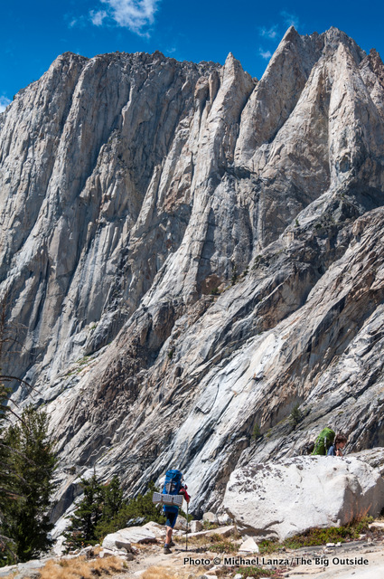
It’s our third morning, and we’re facing our biggest climb of the trip: more than 3,000 feet, spread over 6.4 miles, to 10,700-foot Kaweah Gap. It’s warm but there’s a nice breeze. Most significantly for me, my pack has gotten much lighter—a major relief. My family consumes an impressive volume of food every day, and since I’m carrying much of it, my pack sheds several pounds daily.
By midday, under a hot sun, we reach the largest of the Hamilton Lakes, at 8,235 feet. Everyone needs a break. I start filtering several liters of water while Penny and Tom dig out lunch food and the kids head for the water; before long, we adults join them for a swim. The lake is almost completely enclosed by towering, impassable cliffs and pinnacles, except on its north side, where the High Sierra Trail zigzags up through steep ledges en route to Kaweah Gap—still 2,500 feet above us. [Note: Hamilton Lakes made my list of nicest backcountry campsites I’ve walked past.]
Time for a better backpack? See my picks for “The 10 Best Backpacking Packs”
and the best ultralight/thru-hiking packs.


A bit after 5 p.m., I walk up to the rocky shore of small, oval-shaped Precipice Lake, still 30 minutes below Kaweah Gap. At 10,400 feet, with the nearest tree at least a couple of trail miles below us, the lake’s glassy, green and blue waters sit in a granite bowl, reflecting a white and golden cliff with black water streaks on the opposite shore. A ribbon-like waterfall, originating in a remnant glacier below the north face of 12,040-foot Eagle Scout Peak, pours at least 100 feet down the cliff. I unconsciously mutter, “Wow!” Standing beside me, Tom, who’s backpacked in some spectacular parts of the High Sierra, says, “Yea. Incredible spot.” [Note: Precipice Lake made my list of 25 all-time favorite backcountry campsites.]
Nate had been saying for at least an hour coming up the trail that he would take a swim in Precipice Lake, “although it’s probably going to be pretty frigid.” As we all congregate at the shoreline, he keeps his vow, plunging into the icy waters; then Daniel and I join him. Before long, we reach a unanimous consensus to spend the night here instead of continuing over Kaweah Gap and camping in the Nine Lakes Basin on the other side.
A steady wind rakes the campsite, but it’s beautiful up here. We have a view back down this high valley to the Hamilton Lakes and the row of granite monoliths rising across the valley. High above Precipice Lake, scores of slender spires line up atop a long ridge of Eagle Scout Peak.
While Tom and Daniel and Penny and Alex find flat spots on ledges above the lake for their tents, Nate and I decide to sleep under the stars. We lay our pads and bags out on a flat slab big enough for both of us. Long after dark, the two of us lie in our bags looking up at a sky shot full of stars above the dark silhouettes of peaks.
I can help you plan the best backpacking, hiking, or family adventure of your life. Find out more here.
Hi Michael,
I plan on doing this hike end of August / early September. I am tentatively thinking about making camp the first night in Redwood Meadow grove. What is the closest water source to Redwood Meadow coming from Timber Gap? Or do you recommend a different first campsite?
Good question, Jeff. I’ve updated the itinerary section of the trip planner at the bottom of this story to include info about water along that section of the hike, which you can read when logged into your account as a subscriber to The Big Outside.
Have a great trip! That’s a beautiful hike and you’re going at a perfect time of summer.
Did I miss it? I signed up for Trail medicine. I love the many stories and images here. Being a wilderness guide semi retired at 72 with a 50 yr young body, I will keep in touch.
Maybe the JMT in 2024 or segments there of. Perfer seclusion from crowds so willing to skip Mt. Whitney and Toulume Meadows.
Hey Timothy,
Thanks for the nice words about my blog. Plan months in advance for a JMT hike. I can give you a personalized trip plan for it. See my Custom Trip Planning page to learn how I can help you plan your trip.
We did this trip in 5 days in September, hiking out literally the day before they shut down the park due to the large KNP fire, which started during a big storm while we were camped at Hamilton Lakes on day 2. Fortunately, we were blissfully unaware of the fire until the final descent into the smoke-filled (but still safe at that point) valley, and had good weather other than the storm on the second evening. Visibility, including at Monarch lake just before the descent, was great until the end.
Rangers were not allowing camping at Columbine Lake for at least the season due to previous issues of lack of cat hole opportunities. The climb up to Precipice Lake is a real grind and all parties on our route elected to do it in the morning rather than the end of the day. Precipice and Columbine in the clear morning light were indeed among the best backcountry views I have seen, with Precipice being especially unworldly.
We elected to spend the first night in Redwood Meadow, which is dry and requires hauling water the last 2 miles or so but is worth it given the pleasures of having the entire site to ourselves at the base of massive Sequoias. Just about everybody we talked to on the trail/in camp agreed the hike was more strenuous than we expected, but was doable and certainly well worth the effort. I highly recommend it.
Thanks to you, Michael, for putting it on our radar and giving an excellent description. A couple on our same schedule used your detailed services and were very pleased with those as well.
Hi Michael,
Thanks for sharing those great details about your trip, very helpful to all readers. I’m glad your timing was as good as it was, allowing you to enjoy clear skies and still get out of there safely. I’ve had experiences of squeezing in a trip right before a wildfire blew up, too. And a friend and I got in a really nice, four-day hike in Yosemite in September between waves of smoke from High Sierra fires.
Keep in touch!
Do you think June 20th would be too early to hike this loop? I don’t mind some snow but I’m not sure how much would we would encounter at elevation that early in the season.
Thanks!
Hi Kerrie,
Yes, I think you would encounter substantial snow cover in the second half of June at these high elevations, making it difficult to hike and follow the trail at times, and possibly hazardous. Creeks could be high and dangerous. I understand the Sierra has had a low-snowfall winter, so there may be places below 8,000 feet where you could hike mostly snow-free by then; but in a normal year, it’s mid-July before higher elevations are snow-free, and you’re looking at dates a few weeks early.
I’ve been asked by other readers to help them find a Sierra trip they could take in late June. Getting a permit this close to your dates is difficult, too. But if you’re interested, see my Custom Trip Planning page to learn how I can help you plan your trip.
Thanks for the good question.
5
Hi Michael,
Great article! Do you have any recommendation on packs for a family hauler? I saw you mentioned yours was 85 liters. Do you feel that’s a good size for a small-medium sized family? Any brand or model recommendations?
My wife is pregnant and I’d like to get a larger pack to take some of the strain off her when we backpack while she’s pregnant and then use that for years to come with kid(s) in tow!
Keep up the good work!
Hi Mike,
Thanks for the nice words. It’s a great trip. As you know, I’d be happy to help with planning it. See my Custom Trip Planning page.
See also my picks for “The 10 Best Backpacking Packs.” When my kids were younger and couldn’t carry their share of gear and food, I often used the Gregory Baltoro. But I would also recommend a close look at the Osprey Atmos AG series and the Arc’teryx Bora AR series. I don’t think 85 liters is absolutely necessary, unless you’re hauling a really huge load, but if you’re carrying a large share of the family load, you probably want at least 75 liters.
Good luck and keep your back strong!
Thanks for the write-up Michael! Planning on doing this loop this summer so very excited! I see you hiked this route clockwise. Do you recommend doing it clockwise versus counter? I will be doing the loop over 4 days. Thanks so much!
Great question, Jason. Yes, hiking clockwise is much better. As I mentioned in the Concerns section at the bottom of the story, the descent from Sawtooth Pass to Monarch Lakes is a long, steep slope of loose scree with no real trail. It’s difficult going down, and poles help a lot, but if you’re fairly comfortable on scree (sliding a bit on your heels, leaning backward so that, if you fall, it’s on your butt rather than forward), it can go relatively quickly. But we saw people going up it, and that looked extremely slow and tedious: one step up, half step slide back down. Not to mention that I’d rather do this on the last day of the trip, with a lighter pack going downhill, than on the first day with the trip’s heaviest pack weight going uphill.
Have a great trip. It’s beautiful.
Hey Michael, will be doing this trek this week. Super excited! Have done some research and have a few questions: Spring Lake looks like an awesome spot. Can you reach Spring and Cyclamen Lakes from the Columbine Lake area or can you realistically only reach it from the Black rock pass side? If the latter, may save that area for a future Mineral King Trip… Would really love to camp at Columbine Lake but if I were to do that my third day would be real long (camping at Precipice Lake night two) and my fourth (last) day would be quite short. Mileage wise, it would make more sense to camp somewhere at Big Five Lakes or Little Five Lakes. I am sure there are great spots to camp there too but wanted your thoughts on whether you would extend that third day just to camp at Columbine. Looks sick. Lastly, trying to decide where to camp that first night. Little Bearpaw Meadow or Bearpaw Meadow HSC area. Thoughts? Thanks so much in advance!
Hi Jason, enjoy it, great trip. I did not explore whether Spring or Cyclamen lakes could be reached by hiking off-trail from Columbine Lake or Black Rock Pass; there may be cliffs barring access, or there may be a route, depending on skills and personal comfort level, of course. Yes, it’s a very big day from Precipice Lake to Columbine Lake; we had an intermediate campsite in between those two nights. I think Precipice and Columbine are the two nicest campsites on this trip; that’s why they both made my list of 25 favorite backcountry campsites. So I would camp at both, but only if it fits into your daily hiking-distance capacity. When we were there, camping was prohibited around the Bearpaw Meadow High Sierra Camp; the only option was the Bearpaw Meadow backpackers campground, which is in the trees, lacking views, and kind of dusty, but fine. Good luck!
Good stuff Michael. Really appreciate the feedback!
You’re welcome, Jason, and as always, thanks for asking some good questions.
Just made it back! Another spectacular trip in the Sierras. Did this over four days, which required a good amount of miles each day. As you say, this is probably done best over 5 or 6 days. Everyone starting over Timber Gap with me was doing the same amount of days but was instead doing Blackrock Pass/Sawtooth Pass loop! Ended up camping at Hamilton instead of Precipice b/c I added in a side trip to Tamarack Lake so was too tired to make the late afternoon ascent to Precipice. Tamarack is a beautiful spot if you haven’t been. Camping at Hamilton was spectacular! Also camped in Big Five Lakes basin, another gorgeous spot. Would love to do another trip in which I explore Nine Lakes Basin and Kaweah Basin (cross-country). Lastly, loved Lost Canyon & Columbine Lake area. Overall, some of the best scenery I have seen in the Sierras. Thanks for all your help; your write-up was extremely helpful with the planning!
Thanks for that report, Jason, and congrats. That’s a full-value hike in four days at those elevations. You had the same impression I did when I backpacked it with my family: It’s an incredibly scenic trip. I also felt the desire to go back and explore Nine Lakes Basin and Kaweah Basin more, and I’ll make a note about your recommendation on Tamarack Lake. I’m eager to hear where you’re planning to hike next!
Michael
hi, thanks for the information provided here Michael and i hope you’re still doing well. =) I’m trying to start the trip in a couple of weeks and already have the permits. Just trying to figure out where this Sawtooth Trailhead is exactly and don’t see it anywhere. I don’t think it exists so I’m guessing I just drive to the end of the Mineral Kings Road 2.6 miles pass the Mineral King Ranger station?
Hi Daniel, read the Make It Happen section at the bottom of the story (above these comments), the Sawtooth Trailhead is a short distance before the end of Mineral King Road. You can’t miss it. You’ll see on the map that you climb 0.6 mile from the trailhead to a fork in the trail; to the left is Timber Gap (the direction we hiked), to the right are Monarch Lakes and Sawtooth Pass.
Have fun.
I ran across your site recently when searching for backpack loops in Sequoia and thankfully found this loop you and your family did – looks absolutely amazing! Will be doing this with a small group of young, relatively fit, adults in early September and will for the most part follow your route, although due to permit availability issues, we’ll be doing it in the opposite direction (going up Sawtooth pass on the first day). If we wanted to extend the trip to 40 or 45 miles (over 6 days), do you have any suggestions on adding some mileage onto this route at any point? Thank you!
Hi Michael, thanks for following my blog, I hope you subscribe (see box at bottom of the story, above these comments). You’ll love this hike. But be forewarned: The ascent to Sawtooth Pass is off-trail, steep, and loose above Monarch Lakes. Try to find any user trail you can and the lowest-angle route, and plan on it being slow and laborious. Better to do it as early as possible, for cooler temps. Descending from Sawtooth Pass to Columbine Lake is much easier.
The loop is nearly 40 miles, so to extend it to 45 miles doesn’t add much distance. If you have the time, I would suggest just exploring off-trail up into the Nine Lake Basin, maybe camping at one of the upper lakes; it looks nice from Kaweah Gap. Or take the short side hike from Little Five Lakes to Black Rock Pass (as I did early one morning), or hike in to the Big Five Lakes.
Good luck.
On behalf of Aaron, Matt and Mike (friends that went with me on the trip), we thank you for posting your trip on your website and giving us the idea to do the same trip. It was hard but very rewarding trip and we would not hesitate doing it again. Camping at Hamilton Lake afforded million $$ view and deserves a couple of nights. Equally impressive were Columbine Lake, walking thru the high alpine meadows with the wildflowers in full bloom and several thunderous waterfalls.
I salute your kids for accomplishing such an epic feat. It was more than a walk in the park.
-Noel
Hey Noel, Aaron, Matt and Mike, I’m delighted you guys had a good time. Tough but beautiful hike.
Great story and adventure. We too have brought our Kids backpacking but now they are 18 and 20 and go on their own. My wife and I plan on doing this loop in August of this year. We would like to camp in Redwood Meadow under the Giant Sequoia our first night. Do you have some insight on the closest water source?
Thanks, Fred. We also backpacked this route in August. Of course, water sources can vary from year to year, but I don’t recall there being any water in or near the Redwood Meadow Grove. Cliff Creek, which you cross about three miles southeast of the grove, had a strong flow, and I think some of those tributary creeks you cross between Cliff Creek and the grove had water, but I can’t say for certain what you’ll find. I believe we got our next water from the creeks reached within 30 minutes or so beyond the grove. I’d carry enough water to the grove to get through the night. It would be a nice place to camp. Good luck.
Good Morning Fred:
We just did the trip this July. There is no water source at Redwood Meadow. The ranger will tell you that too when you get your permit. The next water source is Granite Creek which is no more than 30min away with moderate elevation gain/loss. Highly recommended getting to Granite Creek as early as you can. There are 3 campsites where you are more than 25′ from the water and one that is questionable. If you don’t mind the thundering water of Granite Creek while you are sleeping, its as good as any campsite that is near flowing water and there are some swimming holes as well.
Thanks for those details, Noel. I do remember Granite Creek and those campsites, nice spot, actually. I love sleeping by running water.
Great Story and trip. You have inspired me to take my three kids hiking this year! Do you think this hike can be shortened to 4 days only? (our little one is 7 years old). Perhaps exiting at one of the points in the route? Thanks!
Hi Lucretia, thanks. Look at a map and you’ll see that you can shorten this loop by returning via Black Rock Pass instead of Sawtooth Pass (which, in addition to being longer, is a hard, off-trail descent). I have calculated how much you’ll reduce the total distance by, but I believe it would be shorter. You’ll need a good topo map to compare, but look at this online map and you’ll get an overview of the area: https://www.nps.gov/seki/planyourvisit/upload/SEKImap1_MapoftheParks-2.pdf. You can also hike a loop over Black Rock Pass to Sawtooth Pass that’s clearly shorter.
Good luck, it’s a beautiful hike.
Hello Lucrecia:
We found out that the map doesn’t tell the whole story. The elevation gains and losses plus the altitude makes the trip challenging. We were averaging 1 mile/hr and were grown men. The ranger also told us the distances on the map are wrong and the trail signs shows the distances a bit further. As for shortening the trip to 3 nights/4 days, you’ll find the last day to be a real bear if you go through Black Rock Pass from Little Five Lakes back to Mineral King Trailhead. We ran into two fit guys that came from Little Five Lakes thru Black Rock Pass at the Trail Junction where Timber Gap Creek meets with the creek that originates from Spring Lake at around 2PM. These guys still have to climb another 2500 ft and over 4 miles back to the trailhead. Suggest extending the time rather than shortening it so that trip will be more enjoyable rather than a death march.
I was looking for a trip to do in Sequoia, and you have it all planned out for me!!! This looks great, and I’m really looking forward to doing something similar in early September. What trail maps would you recommend?
Hi Cathy, early September is an ideal time of year in the High Sierra. See the Make It Happen section at the bottom of the story, which refers to the Tom Harrison map covering this area. Have fun.
Thank you so much for this post! My husband and I just got married this Summer and are planning on starting a family. Depending on how things go we realized pretty late in the season that we might not get a chance to go backpacking in the High Sierra for awhile. So we decided to rearrange our Fall plans and squeeze a last minute backpacking trip in.
My Dad is a naturalist and was a backcountry ranger back in the day and definitely inspired a love of exploring the outdoors in me. He was mostly stationed at Crabtree, but has a special fondness for Mineral King and the area you covered on your trip.
As I planned our trip the Mineral King bug he put in my ear caused my attention to keep coming back to this area. None of the trips I read about in our backpacking books were quite right so I began collaging together a trip based on snippets I read in these books, my own reading of the area maps and what I thought we could comfortably do in 6 days. As usual, when I can’t find quite what I’m looking for, I turned to Google and the Internet hive-mind. I was delighted to find your post! It shaped up and confirmed that the trip I had been imagining was the right one.
It was such a great trip I’d need to write my own blog post to properly describe it!
We followed your itinerary closely, however chose to do a bit of cross-country travel on the 5th day. Instead of staying at Columbine Lake, we decided to stay at lower Spring Lake via Black Rock Pass from Little 5 Lakes exiting over Glacier Pass the last day.
We also almost shied away from the area because our books urged travelers to be in ‘top shape’. We didn’t feel in top shape at the time, but when I found your post I was confident we could do it if a Dad carrying a 60lb. pack and his kids could do it. Your family and a 10yr old girl we met on our trip gives us hope that we will be exploring the backcountry with our own family sooner than we might have thought.
We met the amazing Isabella at Precipice Lake as the sun rose. We were just waking up when she and her Dad arrived having hiked up from Hamilton Lake starting at 4am. They had hiked the tunnel and scariest parts of the trail in the dark! It was Isabella’s first backpacking trip and she carried her fair share of the gear. Precipice was the pinnacle of their trip and sadly the reflective, clear emerald waters were asleep without light on the lake yet.
Thanks again for your adventurous blog – keep up the good work! Just donated!
Wow, excellent photos and great information! Our permit for Rae Lakes was just canceled because of fires in Kings Canyon, and we moved our permit to this trail. A little last minute for planning, but I think it will be amazing. This entry is certainly getting me in the mood!
Thanks Dan, have a great hike.
I just decided to take a week off in September and thought SEKI would be a winner. Ran a search for some loop options and BOOM. The first link I opened was EXACTLY what I wanted.
Damn. That was easy. 🙂
EXCELLENT job with this. The perfect blend of trail info and descriptions. Really appreciate it.
I’ll be visiting Tom Harrison tomorrow.
Thanks, I’m glad you found my website. Get in touch anytime.
hey, what permits did you need, and did you need a permit for each trail.
Also do you have a map of this trip, i can’t seem to retrace your steps and i plan on doing almost the same trip next week!
Hi Marty, info about permits and the map are in the Make It Happen section above. You only need one permit.
Hello Michael. Early in 2015 I contacted you about the Sierra/Kings Canyon loop you blogged about. At that time you provided excellent suggestions for our planning. This July Laurie and I celebrated our 41st anniversary on Sawtooth Pass. It was a great trip and your article really helped pave the way for us. We arrived July 14. We had our share of adventure.
The first four days, one to acclimate and day hike, and three on the trail, experienced beautiful weather. The ranger gave us a forecast that the weather might deteriorate the last three days of the trip and that we would need to make a decision about holding up in Lost Canyon or pushing over Sawtooth to Monarch Lake to avoid exposure at Columbine Lake. Rain, Thunderstorms and hail started at Little Five Lakes so, after sheltering under a large boulder, we decided to lengthen Day 4 and push on to the first Big Five Lake. After a wet night the weather cleared and we started for Columbine. We had spitting rain on and off but the weather held. That is, until we reached the banks of Columbine. Rain, hail and the summit shrouded in fog obscured the trail to the summit. We sheltered and waited for a window. When we saw one we started up. Half way to Sawtooth Pass the thunderstorm returned. We sheltered again and waited. Another window and we gave it everything we had. We couldn’t linger at Sawtooth and so pushed on and completed the loop on Day 5. On the descent we passed a large conifer totally engulfed in flames from a lightning strike. Exhausted but happily safe at our marmot-proof rental car we made our way back down Mineral King Road as night fell. We have a truckload of pictures and a host of new memories to share with family and friends.
All in all it was a beautiful trip. I thought of your children at the most challenging points. They must be real troopers to make those trips. Not easy.
Thank you for your knowledgeable articles and guidance for us all. We deeply appreciate it.
Hey Brian and Laurie, good to hear from you again. What a great story. I’m delighted you made the trip and had such an adventure, and that my story was helpful to you. Yes, my kids are troopers. Get in touch anytime.
Great post! We’re thinking about a similar hike, also in Mid-July. What was the weather like at those elevations? The pics look hot during the day, but did it get cold at those elevations at night?
Thanks!
Thanks, Nate, glad you enjoyed it. Yes, afternoons were hot, nights got down into the 40s or 30s, and mornings are comfortably cool and ideal for hiking, all of which is typical of the High Sierra in July and August. Good luck with your trip.
Awesome photos! This is definitely on my dream list now! Our little ones (ages 6 and 3 1/2) aren’t able to make such a long hike, but we practice doing short 2-4 miles hikes as day adventures and they love them! Can’t wait to try a multi day trip! Did you have any animal deterrents along besides just being safe and carrying the bear boxes?
Hi Katrina, glad you enjoyed this story. Keep up hiking with your young kids and they’ll become great backpackers. We did carry bear canisters but I only carry pepper spray in grizzly country (and there are only black bears in the High Sierra). However, I suspect a lightweight air horn is a good deterrent, although I have not had occasion to test that theory. The one I like is this: http://www.falconsignal.com/shop/sound-911-horn.
Awesome! Definitely need a couple of these to make me feel better about hiking in ‘Big Kitty’ territory of central Cali with children
Really great trip. My daughter would appreciate Alex’s enthusiasm for post-adventure milkshakes.
Michael, thanks for the engaging account and excellent photos of your backpacking adventure. I solo hiked the High Sierra Trail in the last week of September 2012 and it was an absolutely amazing journey. The story I tell others closely reflects the experience you had with your family. I am now spending time outdoors canoeing, camping and hiking with my oldest grand kids and plan in 3 years to return to the High Sierra with at least 2, possibly 3, of my grand kids and hike the trail again. By the way, The campsites at Upper Hamilton Lake are fantastic, it is a great place to camp and would have likely made your list of all time favorites to camp at, as you mentioned it made your list of favorites to walk by. Again, thanks for bringing great memories of the HST flooding back to my mind and making it feel like I just finished the backpacking trip a couple of days ago instead of 2 years ago.
What an amazing adventure this must of been. Love the nice photos to document your journey. Will have to bookmark this for when my kids are old enough to tackle it.
This sounds FANTASTIC. Hmmmmmm, might have to do this one with the kids…….
Incredible post. This should be in a magazine!