By Michael Lanza
A thin, hazy overcast keeps the sun from frying my longtime friend and adventure partner David Ports and me as we descend the Grand Canyon’s South Kaibab Trail—a trail I’ve now hiked more times than I can immediately recall. And yet, watching how the marching, broken clouds cause the light to shift across the broad expanse of canyon visible to us, seeming to repaint and reshape the landscape every few minutes, it still feels fresh and thrilling to me.
Before long, though, as often happens in this canyon, the sun emerges to begin doing what the clouds had protected us from: frying us—figuratively speaking, of course.
It’s the first morning of our four-day, late-March backpacking trip from the South Kaibab to Hermits Rest, finishing via the Boucher Trail (pronounced BOO-shay), a notoriously steep route connecting the Tonto Trail west of Hermit Canyon to the upper part of the Hermit Trail.
 Hi, I’m Michael Lanza, creator of The Big Outside. Click here to sign up for my FREE email newsletter. Join The Big Outside to get full access to all of my blog’s stories. Click here for my e-books to classic backpacking trips. Click here to learn how I can help you plan your next trip.

And I’ll admit that it feels a little repetitive and almost like an inside joke to use words like “notoriously steep” to describe the Boucher, because “steep” should be considered an assumed descriptor for at least portions of any footpath that descends from either the South or North Rim into the canyon’s interior—which typically involve at least 3,000 feet and often more than 4,000 feet of vertical relief over several miles.
The park website’s own ominous descriptions of trails reflect this truth, from the New Hance Trail (“may be the most difficult established trail on the South Rim of the Grand Canyon”) and Tanner Trail (“steep” and “one of the most difficult and demanding developed trails in the park”), to the Hermit Trail (“the upper section of the Hermit Trail is steep and sustained”), Bill Hall Trail (“quite steep and includes a 15-foot scramble”), and the Royal Arch Loop (“considered by many to be the most difficult of the established south side hikes”), to list just a handful of examples. (Note: Links in this story to many other stories at this blog require a paid subscription to read in full.)
Planning a backpacking trip? See “How to Plan a Backpacking Trip—12 Expert Tips”
and “How to Know How Hard a Hike Will Be.”

Still, we’ll discover on this trip’s last day that the Boucher is, indeed, even steeper than all of those trails (all of which I’ve backpacked). More precisely, the park’s description of it warns that “the trail is being slowly reclaimed by erosion—steep, narrow, and covered in a layer of ball bearing-like pebbles. Take your time!”
But while the hike ahead of us will feel challenging and leave us weary at the end of some days, we have a group of six who are ready for it—including a couple of Grand Canyon backpacking newbies who have the fitness and attitude for the difficulty. Besides David, who’s hiked in this canyon a few times, and me, that includes my wife, Penny, experienced in the GC and on countless other trips; Penny’s great friend since college, Annie Black, a first-time backpacker here but with much experience elsewhere; our 22-year-old daughter, Alex, herself with more multi-day hikes on her résumé than she can remember, going back to age five, including twice in this canyon (first time at age seven); and her good friend from college, Harper Meyer, on her first trip here and first with (most of) my family. Harper will meet and exceed our qualifications for backpacking partners: fit, fun, interesting, and badass.
The four women have started our hike by descending the Bright Angel Trail, the most direct route for backpacking west on the Tonto Trail toward the Hermit and Boucher. David and I will rendezvous with them at Havasupai Gardens. He and I have also been up and down the B.A. several times each and chose the South Kaibab because, well, it’s certainly one of the very best trails in the entire National Park System, and we will traverse the only piece of the 95-mile-long Tonto Trail that I have not yet walked: the section that wriggles for about 4.5 miles between the South Kaibab and Bright Angel.
Find your next adventure in your Inbox. Sign up now for my FREE email newsletter.

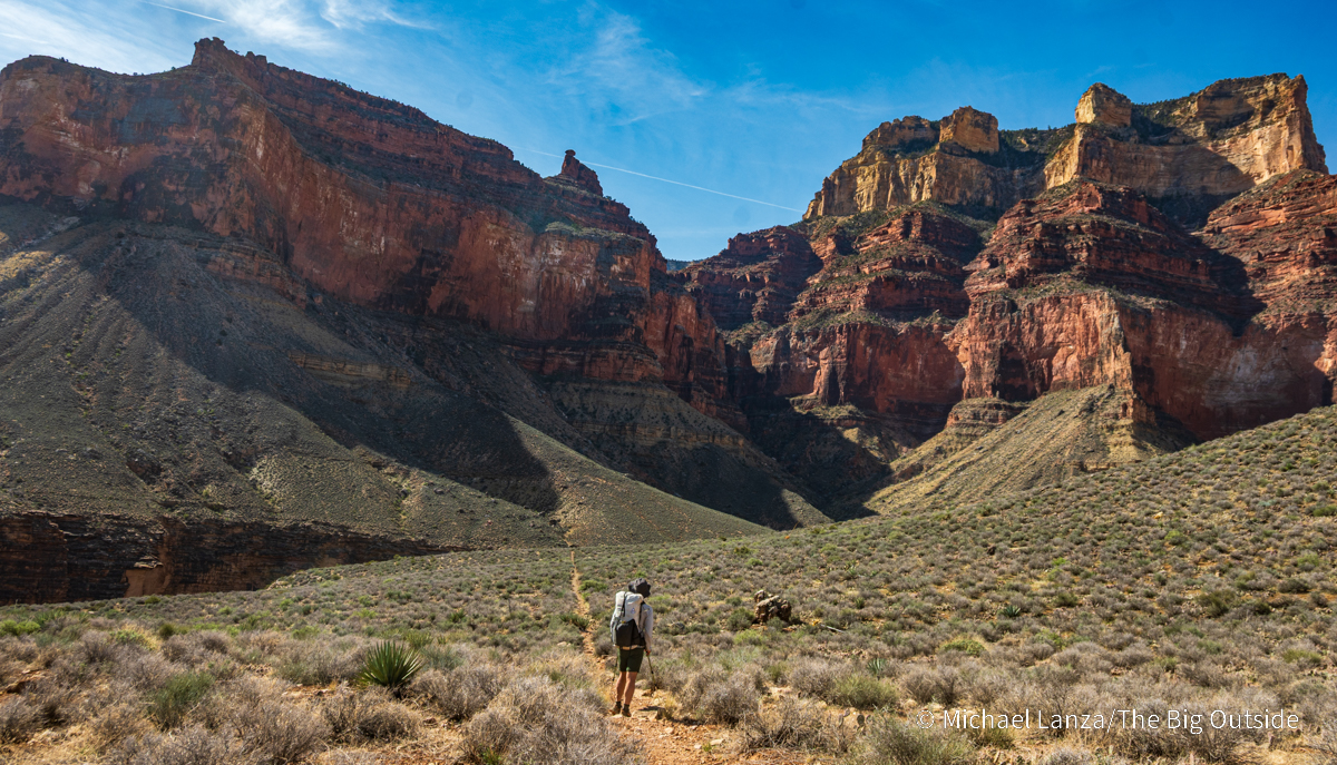
At the Tipoff, where the South Kaibab crosses the Tonto Trail, 4.4 miles and more than 3,200 feet below the trailhead where we started out two hours ago (and still more than two trail miles and 1,500 feet above the Colorado River), David and I turn west onto the Tonto—and within minutes, as I’ve seen happen so many times when hiking one of the park’s three corridor trails (South and North Kaibab and Bright Angel), we’ve left behind a popular trail where we passed dozens of dayhikers and backpackers to find ourselves on a path with long views and, for most of the next couple of hours, not another person in sight.
Like other sections of the Tonto, here it mostly rolls over the Tonto Plateau, dropping slightly to cross the lush, tree-lined canyon of spring-fed Pipe Creek and then reversing that slight descent on the other side. We gaze up at tall cliffs to one side and, in the other direction, out over the Grand Canyon’s chaotic topography, our viewshed spanning the Colorado River to the distant North Rim.
Get my expert e-books to “The Best Backpacking Trip in the Grand Canyon,”
and an easier alternative, “The Best First Backpacking Trip in the Grand Canyon.”

At Havasupai Gardens, we find the rest of our party waiting for us and all set out to hike another hour or more to our first camp at Horn Creek. To all of us, coming from northern states, the afternoon temperature feels hot: It’s in the low 80s Fahrenheit, a bit unusual for late March. But the Tonto Trail continues dealing us a generous hand of easy, nearly flat, and fast walking past spiky plants, the wildflowers not yet in bloom just a week into spring.
At Horn Creek, we have the established tent sites and thin shade of small cottonwoods all to ourselves. When the sun drops behind the canyon rim, the air calms and feels comfortably warm. We sit around trading stories until everyone is ready for sleep. I lay my bag and air mat out atop a large boulder at the edge of the creek bed that I remember sleeping on with Penny on a mild spring night like this one 26 years ago. With no moon, the sky becomes a silent blizzard of stars.
Read all of this story, including my tips on planning this trip,
and ALL stories at The Big Outside, plus get a FREE e-book! Join now!


Horn Creek to Monument Creek and Granite Rapids
The sun already feels warm as we file out of camp in pairs around 9 a.m. Except for sitting in the patchy shade of boulders a couple of times today—and the extended break we’ll take in the deep shade of canyon walls at Monument Creek—the six of us will get no respite from the sun’s heat until it sets behind the canyon rim tonight.
The sun at mid-morning in late March remains low enough to throw both intense light and long, heavy shadows in almost equal distribution across the canyon. A breeze tantalizes us with its cooling effect on open bends in the trail around ridges tumbling off the South Rim, but abandons us as we walk along the lee sides of those ridges, where we feel every degree of the solar heat.
An hour out, as David and I sit in the hard shade of a large rock, first Harper and Alex appear over the saddle between tributary canyons, joined within minutes by Annie and Penny. After a break huddled close together in that shrinking shadow, we all depart together but soon spread out, paired up according to our paces. In this very capable group of family and friends, nobody needs anyone to act as guide. But we always establish the next place where we’ll stop and regroup.
I can help you plan this or any trip you read about at my blog. Click here to learn how.
Contact Grand Canyon National Park, nps.gov/grca. See trail descriptions, including water sources, at nps.gov/grca/planyourvisit/campsite-information.htm.
Not sure this is for you? See my stories “How to Know How Hard a Hike Will Be,” “How to Plan a Backpacking Trip—12 Expert Tips,” and “5 Questions to Ask Before Trying a New Outdoors Adventure,” and this menu of all stories offering expert backpacking tips at The Big Outside.
Want my help planning the details of this trip, including an itinerary appropriate for your group? See my Custom Trip Planning page to learn how I can help you plan this or any trip you read about at this blog.
Let The Big Outside help you find the best adventures.
Join now for full access to ALL stories and get a free e-book!
See “10 Epic Grand Canyon Backpacking Trips You Must Do,” “How to Get a Permit to Backpack in the Grand Canyon,” and all stories about backpacking in the Grand Canyon at The Big Outside.
The Gear I Used See my reviews of the outstanding backpack, sleeping bag, down jacket, air mattress, and stove I used on this trip.
Michael…four days along the Tonto, did you have access to water each day, you mention two creeks and Granite Rapids? They sound “wet.” Reliable sources in late March and/or September/October?
Hi Barry,
Monument Creek and Hermit Creek are both perennial, always flowing, reliable sources. At Granite Rapids or Hermit Rapids, you’re on the Colorado River, which is clear at times, murky other times.
Have a good trip!