By Michael Lanza
When we arrive at the Mangatepōpō Road end to start one of New Zealand’s most beloved dayhikes, the Tongariro Alpine Crossing, the air remains cool, a bracing wind rips across the almost barren, volcanic landscape, and the cloud ceiling hangs so low you can almost reach up and swipe a hand through the fog’s underbelly. But this is New Zealand, where if you’re going to pass on a hike because of a little inclement weather, you’re going to miss out on a lot of hikes. We—and scores of other hikers all around us—are suited up for the elements and ready to go.
Besides, we’re just happy that the Department of Conservation (DOC), which functions something like America’s National Park Service, opened the Tongariro Alpine Crossing today. It had been closed in recent days because of extreme winds and rain, and I had received an email from our shuttle service yesterday morning warning of the possibility of it getting closed again today. (A follow-up email by the end of the day confirmed that the crossing would open today.)
 Hi, I’m Michael Lanza, creator of The Big Outside. Click here to sign up for my FREE email newsletter. Join The Big Outside to get full access to all of my blog’s stories. Click here for my e-books to classic backpacking trips. Click here to learn how I can help you plan your next trip.

It’s late November—late spring here in New Zealand—so strong wind and rain are as common as friendly Kiwis.
My wife, Penny, our 21-year-old daughter, Alex, and I are dayhiking one of the most famous and popular tracks, or trails, in New Zealand: the Tongariro Alpine Crossing, a 19.4-kilometer/12-mile traverse of Tongariro National Park in the central North Island. New Zealand’s first national park, Tongariro was established in 1894—less than two decades after the world’s first national park, Yellowstone, was established in 1872—and is also a dual World Heritage area.

With more than 650 meters/2,100 feet of uphill and a long descent of more than 1,100 meters/3,600 feet, it’s a full day of hiking in mountainous terrain. But those basic metrics don’t fully communicate the difficulty, including the steepness for sustained stretches, the treacherously loose rocks in sections—and the way that strong, chilly wind and rain can amplify your fatigue and threaten inadequately prepared hikers with hypothermia.
But the Tongariro Alpine Crossing deserves to be ranked among the world’s great trails for its almost constant views of active, rugged volcanoes, massive craters, and lakes that all but glow with color. Not to be confused with the 44.9-kilometer/27.9-mile Tongariro Northern Circuit, one of New Zealand’s 11 Great Walks, typically done over three to four days with nights in mountain huts, the Tongariro Alpine Crossing enables hikers to see much of Tongariro National Park’s most dramatic scenery in a day.
Find your next adventure in your Inbox. Sign up now for my FREE email newsletter.


Exposed to the Elements
Not long after we set out from the Mangatepōpō Road end, hiking steadily and, at times, steeply uphill, the rain and wind begin slowly growing more intense; by the time we start across the broad and pan-flat South Crater—now fully exposed to the elements in a moonscape where the occasional vegetation consists of moss and lichen and a few scattered plants growing barely above ankle height—the rain flies horizontally on powerful gusts, pelting us. We push forward, leaning into the tempest, completely suited up in rain jackets with hoods up and rain pants.
I can help you plan the best backpacking, hiking, or family adventure of your life.
Click here now to learn more.

Somewhere off to our right, the tall and steep-sided, rocky cone of Mount Ngāuruhoe looms above us, and to our left rises another volcano, Mount Tongariro—but right now, it’s all lost in this pea soup. The rain and wind intensify as we make the hard grind up the day’s steepest ascent, about 150 meters/500 vertical feet to the rim of Red Crater, the track’s high point at 1,868 meters/6,129 feet.
And then the rain suddenly fizzles out and stops, although we remain fogged in.
Descending the steep north side of Red Crater, over loose volcanic rocks large and small, I’m taken completely by surprise when my feet fly out from under me and I’m airborne for an instant before landing on my butt (unhurt). Back on my feet quickly and continuing downhill, just minutes later, it happens again—completely surprising me again.
The reason, it occurs to me, is that these loose rocks and scree consist of scoria, a type of volcanic rock fragment that’s very light and often somewhat rounded and more prone to roll underfoot than the rocks in non-volcanic mountain ranges. For the rest of this steep descent, which is only about 90 vertical meters/300 vertical feet, I take an even slower and more cautious pace than I normally take in terrain like this (which I’ve hiked hundreds of times over the years).
And then, something happens that is not unusual in New Zealand: The weather changes abruptly.
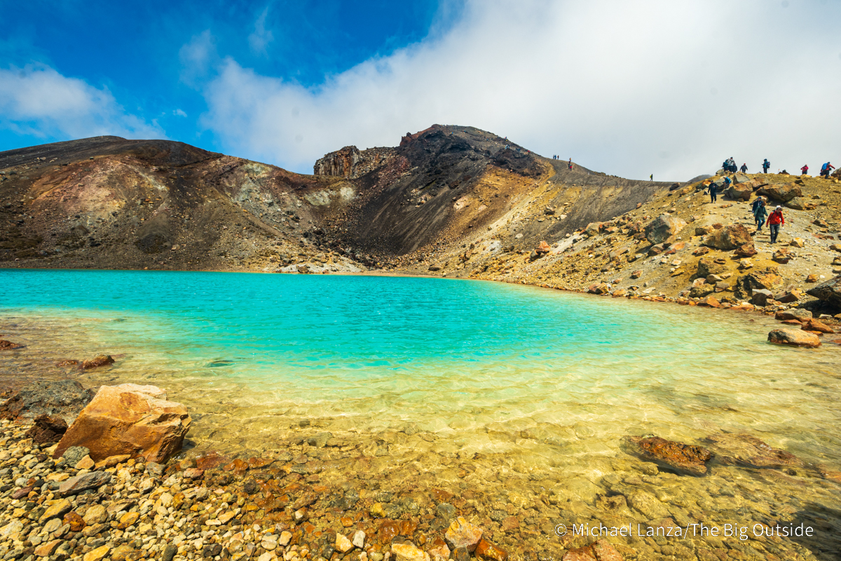
Within minutes, the clouds shred into non-threatening, cute little cotton balls floating across the sky. Although the wind continues and still feels cool, the sunshine bathes us in warmth and starts drying out our rain shells. The three aptly named Emerald Lakes, two of them small and the third just a tarn, barely larger than a swimming pool, appear below us, brilliantly green in the sunlight.
Join now to read all of this story, including my expert tips on planning this trip,
and ALL stories at The Big Outside, plus get a FREE e-book!

Emerald Lakes and Blue Lake
Alex, Penny, and I stop at the largest of the Emerald Lakes, which sits beside the track, walking along its shore and taking pictures. Other hikers are doing the same, luxuriating in the sudden warm sunshine and the otherworldly colors of the lake water and the geology. On the lake’s far side, crumbling slopes of white, golden, and black rock appear to be traveling in erosion’s passing lane.
Minutes beyond the Emerald Lakes, we stop at an overlook above the larger Blue Lake, known also by its Māori name Te Wai Whakaata o te Rangihīroa, cradled in a rocky bowl at the foot of the peak Rotopaunga—yet another black cone of crumbling rock. The lake sits on the edge of another pan-flat basin, the Central Crater, encircled by walls of dark, volcanic rock, with Mount Tongariro—now fully visible to us—rising over the far side of that crater.
I’ve hiked all over the U.S. and the world and I’ve personally seen very few treks through volcanic landscapes that compare to Tongariro (although Iceland’s Laugavegur Trail certainly comes to mind).
Plan your next great backpacking trip in Yosemite, Grand Teton,
and other parks using my expert e-books.

Not sure this is for you? See my stories “How to Know How Hard a Hike Will Be” and “5 Questions to Ask Before Trying a New Outdoors Adventure.”
The Gear I Used See my reviews of the outstanding daypack, rain jacket and pants, and fleece hoodie I used on this hike.
See my story about my first hike in Tongariro National Park (several years before the New Zealand Department of Conservation began strongly discouraging hikers from visiting the summits of the park’s volcanoes), plus all stories about trekking in New Zealand, including my stories about hut treks on the Routeburn Track, Milford Track, and Kepler Track, all stories about adventures in New Zealand, and all stories about international adventures at The Big Outside.
Click here now to get more than 20% off on my expert e-books to three great world treks:
The Tour du Mont Blanc, New Zealand’s Milford Track, and Iceland’s Laugavegur and Fimmvörðuháls Trails!
These blog posts may also help you prepare for the Tongariro Alpine Crossing or other hikes in New Zealand:
“How to Prevent Hypothermia While Hiking and Backpacking”
“8 Pro Tips for Preventing Blisters When Hiking”
“5 Tips For Staying Warm and Dry While Hiking”
“7 Pro Tips For Keeping Your Backpacking Gear Dry”